


Updates regarding loss of microwave satellite data
Intense heatwave continues in western Europe
Good morning and welcome to a new week. There was some updated information in the media this weekend regarding the impending loss of data from the Defense Department’s Special Sensor Microwave Imager Sounder (SSMIS) polar orbiting satellite instrument. As I discussed in this article Friday, SSMIS microwave data is used in a variety of meteorological applications, but is probably most important for its use in hurricane forecasting, as it provides a kind of X-ray view of the structure of a tropical cyclone that allows forecasters to better pinpoint the location of a system as well as structural features indicative of impending rapid intensification.
The data was scheduled to be terminated today per a release from NOAA last week. However, NOAA released an updated service notice stating that the termination was being delayed a month based on a request from “Dr. Germain from NASA to postpone the removal and distributing DMSP data through July 31st.” As Andrew Freeman from CNN reports in his article about all of this from this morning, this appears to be a reference to Karen St. Germain, the division director for NASA’s Earth Science Division.
To be honest, the more we learn about this entire situation, the more confusing and frustrating I find it. While any delay in losing this data is obviously a positive and this postponement will keep the data available for any tropical systems in July, major tropical impacts in July are relatively rare, and the data will still not be available for the peak tropical season months of August through October.
Furthermore, we have learned that the loss of the SSMIS data this summer is simply an acceleration in the timeline of a data termination that was already planned for late in 2026. The DoD does have a replacement microwave instrument - the WSF-M - in orbit and operational, but from what little information I can find about it online it does not seem to have the data resolution to be a replacement for the SSMIS data with regard to the hurricane forecasting applications. It is referred to as a “gap-filler” instrument on this instrument summary page, and the WMO catalog page for the instrument appears to show an instrument with less capabilities than the SSMIS. I did learn from a colleague in the satellite community over the weekend that there are plans for NOAA to get access to the WSF-M data, and I believe Andrew Freedman is referring to that instrument in his article when he says that NOAA should start getting access to microwave data from a new DoD satellite in October.
Even if the WSF-M ends up being a more comparable instrument to the SSMIS than it appears to be from what I can find online currently, it is only one satellite instrument, while the SSMIS data is available from three satellites, so we would still be talking about a significant cutback in the data available to forecasters and degradation of forecasts and warnings regardless. In spite of NOAA spokespeople downplaying the loss of SSMIS because it “is a single dataset in a robust suite of hurricane forecasting and modeling tools in the NWS portfolio,” the fact is SSMIS is a unique, critical data source that there does not appear to be any plan for losing.
I encourage you to read this NBC News article from Evan Bush in which he talks to a number of experts about the impacts of losing the SSMIS data. I highlight this summary quote from Brian McNoldy, a hurricane researcher and senior research associate at the University of Miami’s Rosenstiel School of Marine, Atmospheric, and Earth Science: “It’s definitely a significant loss. There’s no doubt at all hurricane forecasts will be degraded because of this.” From everyone I have talked to and all the articles I have read (and my own perspective), this is the consensus view on the loss of the SSMIS data.
While I am incredibly frustrated by the lack of helpful, productive communication about this situation from the current administration, the fact is that this data termination was already being planned for 2026, which indicates that the decisions resulting in the loss of the SSMIS data without a viable replacement for hurricane forecasting applications were made years ago. I admit to being confused, concerned and frustrated about those decisions and the apparent lack of communication about them given the universal surprise being expressed by the weather community since the announcement of the data loss came late last week. The bottom line, though, is that in my 35 years as a meteorologist, there have been very few times I can recall where we took a distinct step backwards in any of our forecast and warning capabilities; this certainly seems to be a clear step backwards, and I fear it may be the first of many.

Turning to the actual weather, today will a somewhat quieter weather day than we have seen of late. Scattered to numerous showers and thunderstorms can be expected over much of the country, and while some of the storms may certainly be strong or occasionally severe, there does not look to be much in the way of organized, higher end severe weather potential for today. Pockets of more organized, slow moving complexes of storms could organize along a slow moving cold front; this could result in some flash flooding, and a slight (level 2 of 4) risk is in effect for several areas along the front as shown above.
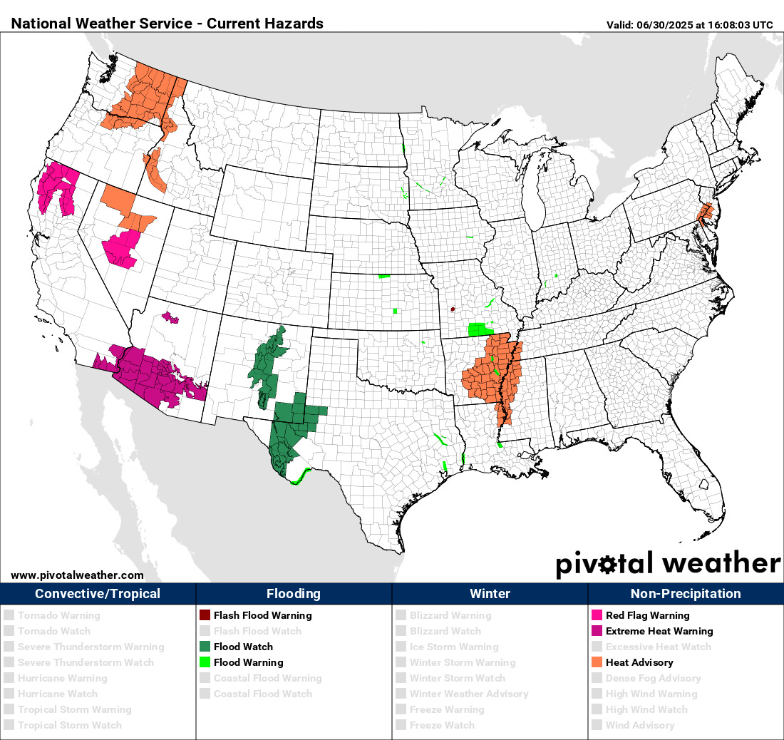
Heat and fire danger will be a concern today in the western United States, and red flag warnings, heat advisories and extreme heat warnings are in effect for a number of areas. Phoenix hit 114F on Sunday, and looks to reach or exceed 115F the next couple of days.
The record heatwave continues in Europe as well, with dozens of monthly records set again today in France, Spain and Portugal. This comes after Mora in Portugal hit 46.6C (116F) on Sunday, setting another national record for the month of June.

On Tuesday, the front currently in the middle part of the country will reach the East Coast, and will have a bit stronger upper level forcing associated with it. As a result, more organized severe storm activity is anticipated, and a slight (level 2 of 5) risk in place for portions of the Mid-Atlantic. Some flash flooding could also occur in this region given the very wet conditions of the last several weeks.
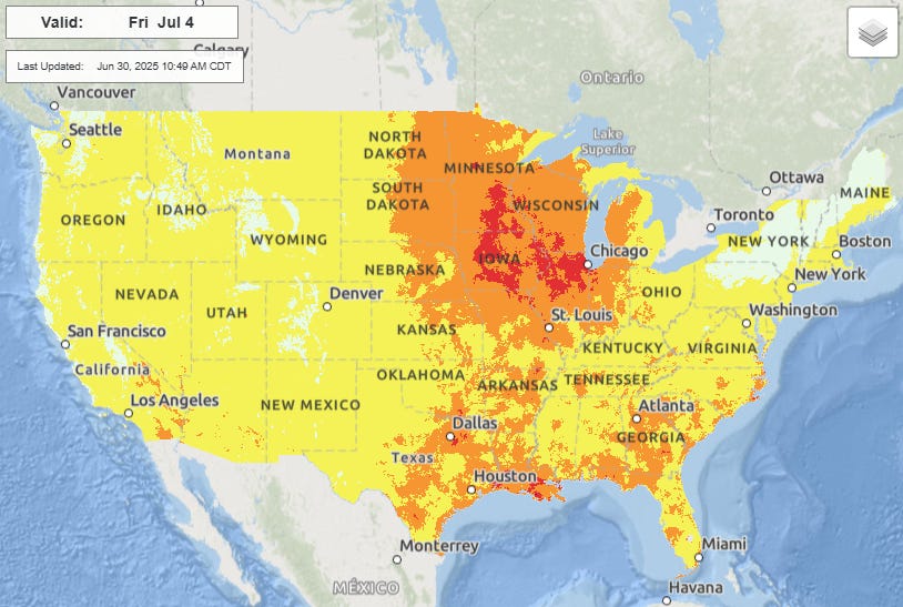
The weather pattern for the rest of this week heading toward the July 4th weekend looks relatively non-descript, with heat gradually shifting from the West to the middle part of the country by the 4th.
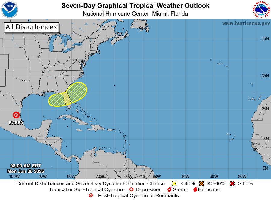
In the tropics, Barry made landfall and dissipated as anticipated in eastern Mexico, while we continue to keep an eye out on the area off the Southeast US coast for potential development later this week. Flossie continues slowly intensifying in the eastern Pacific, and should become a hurricane soon. I will have a full tropical newsletter later today or Tuesday morning.
I'm sending this to BlueSky where doubtless many will share your concerns.