


More flash flooding in Oklahoma and Texas last 24 hours
Wildfire smoke in the upper Midwest and keeping an eye on the Gulf

As anticipated, flash flooding was a big weather impact over the last 24 hours, with 70 reports of flash flooding scattered primarily across the Southern Plains and Mid-Atlantic regions.

The most widespread heavy rainfall was over the Southern Plains region. Thunderstorms with intense rainfall rates developed across the northwest parts of the Oklahoma City metro region late Saturday afternoon, with reports of over 6” of rain in 3 hours in spots. An NWS employee in the western OKC suburb of Yukon reported 5.75” in 70 minutes, including 2.75” in 30 minutes, truly impressive rainfall rates. Needless to say, this resulted in some significant urban flash flooding, with numerous roads inundated and vehicles caught in flood waters.
Overnight, slow moving clusters of storms with high rainfall rates progressed slowly south across central Texas, resulting in widespread rainfall greater than 2” and numerous swaths of 4-8” of rainfall in a matter of a few hours.

This rainfall has resulted in significant incidences of flash flooding. As an example, the river gage on the Lampasas River near Kempner, TX shot up more than 30 feet in 5 hours: from 1.84’ at 4 am CT to 32’ at 9 am CT.

While the flooding has been significant, as of this point I have not seen any reported casualties with this flooding as of now. The Guadalupe River however is now forecast to rise into moderate flood stage again at Hunt this afternoon, which is resulting in the suspension of recovery efforts from the catastrophic July 4th flash flooding.

Additional flash flooding is anticipated across central and southern Texas this afternoon, though luckily in the last couple of hours the showers and storms have become more progressive, resulting in the rainfall becoming less organized and heavy across the region. Still, more focused activity could redevelop in the very moist atmosphere in the region, and a moderate (level 3 of 4) risk of flash flooding is in effect for parts of central Texas. Additional slight risks (level 2 of 4) for flash flooding are in place in the Middle Mississippi Valley, the Mid-Atlantic and northern Appalachians, and in parts of New Mexico including Ruidoso which is still recovering from major flash flooding last week.

Severe thunderstorms will also be possible today, with several regions of the country under marginal (level 1 of 5) risks. A slight (level 2 of 5) risk is in place for parts of upstate New York and northern Pennsylvania where more organized severe storms with damaging winds are possible.
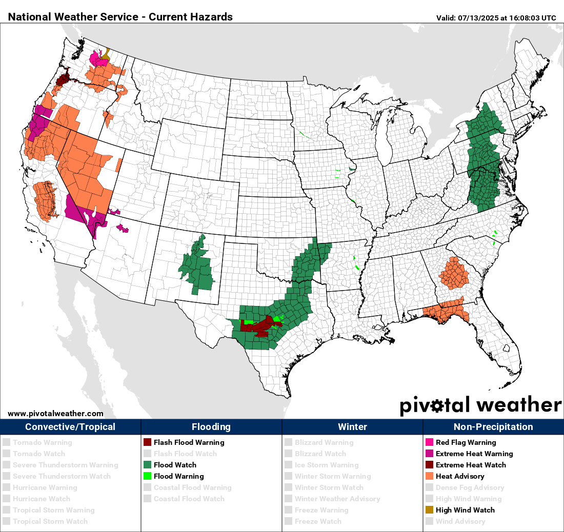
In the western United States, heat and fire danger will continue to be the concerns today, with heat advisories, extreme heat warnings and a few red flag warnings in effect. A few record high temperatures will be possible in northern California and Nevada.
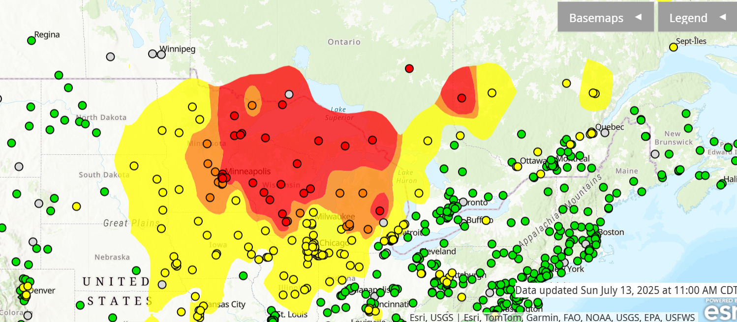
Canadian wildfire smoke has overspread the upper Midwest and western Great Lakes region, causing increasingly poor air quality in the region.

The High Resolution Rapid Refresh smoke model shows waves of wildfire smoke continue to work southeast from central Canada into the region the next 48 hours. Air quality advisories are in effect for all of Minnesota, Wisconsin and Michigan.

Finally, an area of disturbed weather has developed off the Southeast coast. This weak weather system will move slowly west over the next couple of days, bringing increased moisture and thunderstorms to Florida.

The Weather Prediction Center has place a slight (level 2 of 4) risk of flash flooding for much of the Florida Peninsula on Friday associated with the heavy rainfall risk.

As we talked about in last week’s weekly tropical update, conditions look as if they will become marginally conducive for tropical development as this system continues to move west across the northern Gulf this week. Right now there are mixed signals in the computer models for this system, with a couple of models being rather aggressive with development, but most models and ensembles showing a weak system or little development at all. NHC currently has a 20% probability of tropical cyclone development, and obviously we will watch it this week.