


Quiet week in Atlantic after Chantal; East Pac quieter as well
July 8, 2025 weekly tropical newsletter

Let’s start off this week’s tropical update with a look at where we stand as far as tropical activity in the Northern Hemisphere courtesy of Colorado State University. Tropical Storm Chantal made landfall in South Carolina as a 60 mph tropical storm on Sunday morning, by far the strongest and most impactful Atlantic cyclone so far this season. It produced significant rain and major flooding in parts of central North Carolina as I talked about here. Chantal was still a short lived storm only lasting about 24 hours, and even with 3 named storms, the Atlantic is somewhat below normal on all measures of activity except named storms. Again, though, it should be stressed that Atlantic tropical activity in June and July has little correlation with how active the rest of the season will be.
Eastern Pacific activity so far this season is somewhat above normal, with Accumulated Cyclone Energy (ACE) - the most useful parameter for judging the overall seasonal activity based on length, size and intensity of each storm - now at 130% of normal. The most notable trend in global activity though has been below normal activity in the western Pacific, where ACE is 30% of normal.
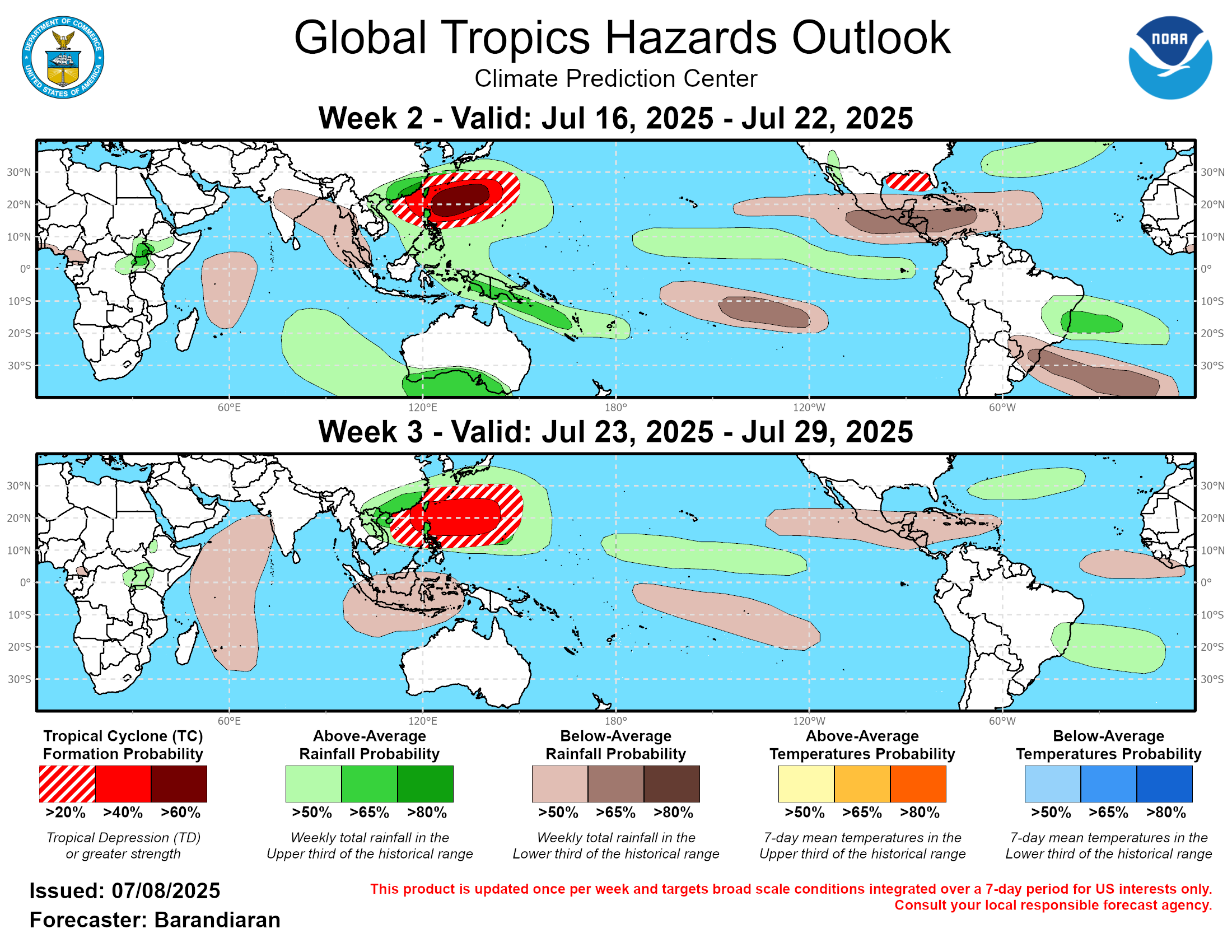
The western Pacific looks to begin to try to make up some of that deficit over the next couple of weeks, as the Climate Prediction Center is forecasting above normal probabilities of tropical cyclone formation in this region for the next 2 weeks. Meanwhile, the eastern Pacific and Atlantic are generally looking at below normal probabilities of activity over the next few weeks.
The one exception to this could be over the northern Gulf of Mexico, where some long range models have suggested there could be a somewhat favorable environment for development underneath a large upper level area of high pressure developing across the southern United States. At this point this looks like a low probability scenario - CPC only shows a 20% probability of development - but it’s the one area in the Atlantic that as of now looks like it should be watched.

The Madden-Julian Oscillation - the large scale global tropical feature that governs more favorable periods and regions for tropical activity - has been weak for several weeks, but model forecasts suggest it will become more active again over the next 2 weeks. The models show it strengthening and moving into phase 6 by the middle to later part of the month, which should further favor tropical activity in the western Pacific (the graph above shows the intensity and location of the MJO signal with a dot and a number for the date, meaning the model is showing it in phase 6 by July 22nd). Should the MJO become active and continue to propagate east, it could become an enhancing factor for Atlantic tropical cyclone activity as we get closer to the start of peak Atlantic hurricane season in August.


The change in global sea surface temperature (SST) anomalies (amount the temperature is above normal) shows that anomalies have weakened from record warmth in the Gulf and northwest Caribbean, but SSTs are still well above normal in these areas. The rest of the Atlantic basin has seen warming over the last month and above normal SSTs appears as if they will be in place for most of the Atlantic as we approach the peak of hurricane season. While this is by no means a guarantee of an active season, above normal SSTs, particularly in the Main Development Region (MDR) east of the Caribbean, is one of the primary signs of a potentially above normal season.