


CNN reporting NWS to hire 125 new staff
Some initial thoughts about implications
Going to start off this morning’s newsletter with some breaking news that’s not actual weather, but important for the weather enterprise. CNN’s Andrew Freedman just posted a story that the National Weather Service has been authorized to hire 125 new staff. This news comes just as we enter the start of the 2025 hurricane season that multiple media outlets are reporting that the NWS is not prepared for. Just this morning The Guardian published a well sourced article about how NWS and FEMA are struggling and likely not ready to handle the upcoming hurricane season.
So on a very basic level, this news from CNN would seem to be a positive step toward rectifying this situation - and at a fundamental level it is, getting more staff onboard would be a positive. However, to me this news has so many more troubling implications that I think are important for people to recognize. The first is that the fact that the NWS is being authorized to make these hires during a government wide hiring freeze is a clear admission that - despite their spokespeoples’ frequent statements that all is well with NWS - the administration clearly realizes that all is not well with NWS and corrective actions need to be taken.
Furthermore, this is unlikely to have any meaningful impact on the upcoming hurricane season. Even in the best of times, it takes months to advertise positions, go through the hiring process, move people to the location where they’ve been hired, and then train them on the basics of doing the job. Unless something has fundamentally changed in how the federal government is doing hiring in the three months I have been retired, I cannot imagine that this hiring plan will be able to make any real difference as far as NWS staffing for this season, and certainly during the peak months of August and September.
The reassignment opportunity that the NWS is working on that I talked about a couple of weeks ago and that Andrew alludes to in his article has more hope of making a difference to some of the most critical staffing shortages. Even this effort, though, will take time: the process of making selections for the reassignments is just starting, and it will take weeks for the administrative staff to implement the processes to authorize moving expenses and actually get people moved to their new locations. It seems more likely that the NWS will have to manage crucial staff shortages during any landfalling tropical cyclones by temporarily deploying people at understaffed sites.
The overarching thought going through my mind this morning is this: ALL of this could have been avoided by not taking a hatchet to NOAA and NWS in the first place. I have worked my entire career in the public sector, so maybe the concept of making massive cuts to a business and then repairing the most critical aspects makes sense in the private sector. It makes zero sense to do it to government agencies that are responsible for keeping the public safe from natural disaster. NOAA/NWS has essentially lost thousands of years of experience through the recent early retirement/buyout process that OPM executed. That experience can never be replaced. Many of the early career people who we could have hoped would eventually build some of that experience back were terminated during the release of probationary employees.
As the NWS starts to try to hire these new 125 staff members, does anyone think that any of those probationary people that were let go are going to come back to federal service after the way they were treated? Will NOAA and the NWS be particularly attractive opportunities to the best and the brightest new scientists after what they have seen transpire in the last couple of months?
Bottom line - this is a crisis of the administration’s making. I will be the first person to tell you that the NWS has been in need of serious organizational changes for years - but it needed to be done smartly and deliberately. What has happened in the last few months is anything but, and in fact is the opposite of “efficiency.” How can there be anything efficient about getting rid of hundreds of experienced people, realizing after doing that (whoops) you actually need these people, and then rush around to try to hire new staff after you have alienated the members of the scientific community you are now trying to hire?
I am going to end my screed about this topic with this: nobody should think that NWS is the only agency that has been left in a highly vulnerable state by what has transpired with the federal workforce in the last few months. As I wrote in my article about the OPM budget release on Friday, NWS is just one part of an integrated infrastructure of federal, state, local and private sector entities that help keep us safe from natural disaster. The federal aspect of that infrastructure is very foundational to the whole effort. The atmosphere does not care that we have left ourselves vulnerable to it, so this hurricane season could very well be a disastrous one that hits us when we are vulnerable. The earth doesn’t care that we have left ourselves vulnerable to it, so today could be the day the Cascadia Subduction Zone releases its pent up energy with a M9 earthquake. This is why so many of us have been screaming for the last weeks - we know what it takes to keep this fragile infrastructure going, and know that you mess with it at your peril. A lot of the damage has unfortunately already been done and we just have to hope we can deal with it as best as we can. The OPM budget though would make it a lot worse. People need to take this morning’s news about NWS staffing as just yet another alarm bell about the road we are heading down.
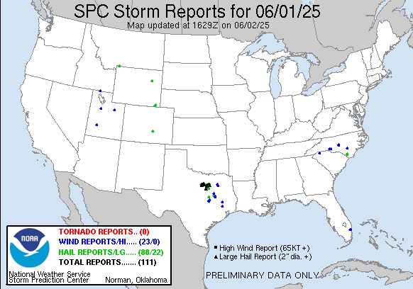
Let’s turn to actual weather. Yesterday we saw another case of a supercell reaching peak intensity at just the wrong location, as a left moving supercell intensified over the southern parts of the Fort Worth metro area, with a swath of very large hail up to baseball size impacting the area.
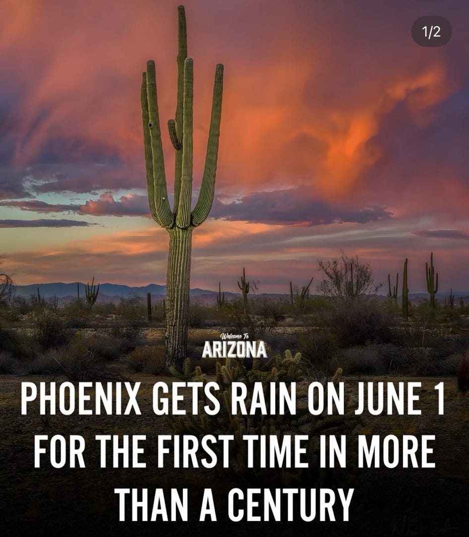
Meanwhile, in the Southwest, moisture from the remnants of the first eastern Pacific tropical storm of the year (Alvin) got caught up with a developing upper level trough in the West to bring some rare early June rainfall to Arizona. Phoenix and Yuma both set daily rainfall records; only .24” at Phoenix and .10” at Yuma, but that smashed their daily records of .02” and a trace respectively!

That same upper level trough will bring an increasing risk of severe weather and heavy rainfall to the Plains region starting this afternoon. The Storm Prediction Center just upgraded the area from western Kansas across the eastern Texas Panhandle to an enhanced (level 3 of 5) risk of severe weather for this afternoon and night. Widespread (potentially significant) damaging winds and large hail are the main risks in the Plains region today but a few tornadoes are also possible.

The risk of severe weather and flash flooding will slowly shift east on Tuesday to encompass the region from northern Texas to the Mid-Mississippi Valley region.
With the start of hurricane season, I put together an article about the expectations for the upcoming season and hurricane forecasting. ICYMI, you can find it here. Right now, still just keeping an eye on the week 2 period in western Caribbean and southern Gulf as some of the ensembles show some development. Hopefully will have more time for weather and less need to talk about other “stuff” in tomorrow’s newsletter!
You are correct in thinking this type of reduction of staff is bad in business also. I recall several studies of publicly traded companies after the 2008/2009 recession. Those which took losses to retain staff showed much stronger stock prices during and after the recession. It was a lesson taken to heart by many during COVID.