


NWS staffing in the news again
Record heat all over the globe, and increasing severe weather in the US
I want to start off this morning’s newsletter by highlighting an article about the National Weather Service from the front page of the New York Times this morning - thanks to Paul Walsh for highlighting, you can find the article here at his Substack note. The article goes into detail on a lot of subjects I have discussed in some of my articles about the NWS in recent weeks, including that NWS was already working on a significant reorganization but that the staffing cuts mandated of the last few months by the Office of Personnel Management and DOGE were derailing those plans and making an already thin staffing situation worse very quickly.
Rather than going into detail about it all again, I encourage you to read the article (it should be gifted at this link). One thing I do want to talk a little more about is another story that has been widely reported about the NWS effort to fill 155 critical vacancies. It is important to recognize that this is not any sort of an effort to hire new people into NWS to fill these critical positions. This is a reassignment program in which people already employed by NOAA (including in other NWS offices) can voluntarily request reassignment to one of these critical positions and the NWS will reimburse their moving expenses. While a few non-NWS NOAA meteorologists (for example, in NOAA Research) may take one of these reassignments to get into an operational position that might be “safer” than their current NOAA position, for the most part this is simply reshuffling the NWS deck chairs to try to better balance the national distribution of the staff after some operational offices were left decimated by the recent voluntary separation (buyout) program. It is a prudent step for NWS leadership to take to try to best reduce negative impacts to services, but it is really a “robbing Peter to pay Paul” approach necessitated by the staffing mandates from the OPM and DOGE. It will also cost the NWS additional budget funds to cover moving expenses for these employees, and I am confident these are funds that the agency would have been able to use more effectively if they had not had to spend them trying to fix a problem forced on them by these external mandates. The plan obviously also relies on people being willing to voluntarily uproot their lives and move to a new location - so how many people will be willing to do that especially in the current uncertain federal government employment remains to be seen.

So now let’s turn to the weather. The heat was on again in the middle of the country, with a number of record highs set in Texas and the Southern Plains. There was one more day of record heat in the north central states as well as International Falls hit 91F and set another record high - cooler weather will now be setting up over this region.

Record warmth is forecast to continue and in the south central states and expand east, peaking on Friday when more than 60 locations are forecast to tie or break record high minimums Friday morning (note: these are the morning forecast lows, some sites could possibly fall lower before midnight and not end up with a daily warm minimum record).
Record warmth is prevalent in many parts of the globe right now, and rather than try to detail it all given I also need to cover severe weather, I encourage you to check out “Extreme Temperatures Around the World” which does a great job of covering what’s happening globally.

Along with the record warmth, severe weather will become an increasing weather story over the next several days. Today as a storm system moves into the upper Midwest and encounters a strongly unstable atmosphere, a number of intense supercell severe storms capable of very large hail, strong tornadoes and damaging winds are expected to develop across the western Great Lakes region. The Storm Prediction Center has a large enhanced (level 3 of 5) risk for much of this area for this afternoon and tonight.
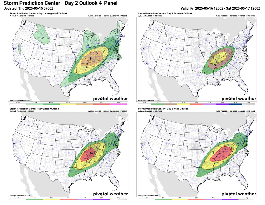
As the cold front associated with this storm system shifts southeast and another strong piece of upper level energy interacts with the unstable atmosphere ahead of it, another day of higher end severe weather potential is anticipated on Friday across the Ohio Valley region, where another large enhanced risk is in place. Very large hail, strong tornadoes and damaging winds will all be possible with the most intense storms in this region.

The cold front will sag south on Saturday, but then as a new upper level storm system develops on Sunday, the threat of severe weather will refocus over the central part of the country Sunday into Monday. These could be significant severe weather days as well that will need to be monitored closely.
Programming Note: I am currently in Florida to participate in the Main Street 16 Challenge at Walt Disney World, raising money for Make-a-Wish of Central and Northern Florida (find out more if interested here). Hence, my posts will be a little more sporadic than normal - and because I will be participating in the challenge event on Saturday, there will not be a newsletter that day.