


Watching the Gulf for a potential tropical system this week
Multiple flash flood risk areas nationally and increasing wildfire concerns
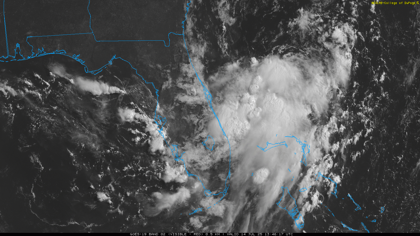
Starting off this morning talking about a potential tropical threat in Florida and the Gulf. This morning’s visible satellite imagery shows a large area of thunderstorms east of Florida, with an area of circulation a few hundred miles east northeast of Cape Canaveral. Most of the thunderstorm activity is south and southwest of the circulation, indicative of northeasterly winds aloft in the atmosphere causing wind shear on the system. This wind shear is expected to continue over the next 24 hours as the disturbance moves west-southwest toward the east coast of Florida, likely limiting any development in the near term.

The northeasterly wind shear means that most of the heaviest rainfall with this disturbance should occur along and to the south of the track of the weak low pressure area, which should generally run somewhere in the vicinity of I-4. Last evening’s High Resolution Ensemble Forecast (HREF) probability matched mean precipitation forecast through Tuesday evening shows that areas of 5 to 10” of rainfall are possible across central and southern Florida as this system moves across. The Weather Prediction Center has outlooked a slight (level 2 of 4) risk of flash flooding for both today and Tuesday for much of peninsular Florida.

Once the system moves across Florida and into the Gulf, conditions appear to become somewhat more favorable for development, with the northeasterly wind shear abating a bit and plenty of moisture and warm sea surface temperatures to fuel convection. Right now the model signals for development are mixed, with a few deterministic and ensemble members rather bullish with a reasonably strong system but most showing weak development. Part of what will affect how much development occurs will be exactly where a system becomes organized and how far off the northern Gulf coast it is. Whatever system there is should generally move west to west-northwest and eventually move inland somewhere along the central Gulf coast late this week.

Regardless of whether a tropical cyclone develops, heavy rainfall will be a definite risk with the system, initially over Florida as discussed above and eventually along the Gulf Coast region. If a stronger system were to develop, this risk would increase.
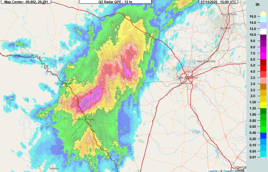

Flash flooding continues to plague parts of Texas this morning, as overnight thunderstorms resulted in a couple of bands of 6-12” of rainfall in 12 hours in the region between San Antonio and Del Rio. Several flash flood warnings for life threatening flash flooding are in effect as the MRMS FLASH unit streamflow product shows several areas of values greater than 10, indicative of significant flash flooding. NWS Austin/San Antonio reports that flood waters were threatening structures near Quemado.

The NWS Weather Prediction Center has a slight (level 2 of 4) risk of flash flooding in place in this region for additional heavy rains and flash flooding today. A significant flash flood risk is also anticipated later today in the Mid-Atlantic region as scattered to numerous thunderstorms are expected to develop ahead of a slow moving cold front heading east across the region.

A couple of parameters on the morning upper air balloon data from the NWS Baltimore/Washington office that I have highlighted with a purple box above are of particular concern. The precipitable water (PW) value is 2.14”, which is at the top of observed values for the middle of July, and the K-index, a measure of atmospheric moisture and instability through the atmosphere, of 36 is very high. Both of these parameters suggest that thunderstorms that form will be capable of intense rainfall rates, with WPC discussing the potential for 3+” per hour rates. Hence, while extremely heavy rain does not look widespread, where these high intensity rainfall rate storms intersect with urban areas or other areas vulnerable to flash flooding due to terrain influences and recent heavy rains, significant flash flood impacts could occur. This is why WPC has a moderate (level 3 of 4) risk of flash flooding in this region.

Heat and fire danger will continue to be the primary stories in the western United States again today, with a variety of extreme heat warnings, heat advisories and red flag warnings in place. A few record high temperatures were set on Sunday, including Reno at 104F and Eugene, OR at 99F. On the fire weather front, the National Interagency Fire Center reported 14 new large wildfires this morning with 36 fires currently uncontained. Eastern Washington state is of particular concern today for wildfire activity as a cold front moving across the region will produce strong winds amid very dry conditions; SPC has a critical fire danger area outlooked in this region.
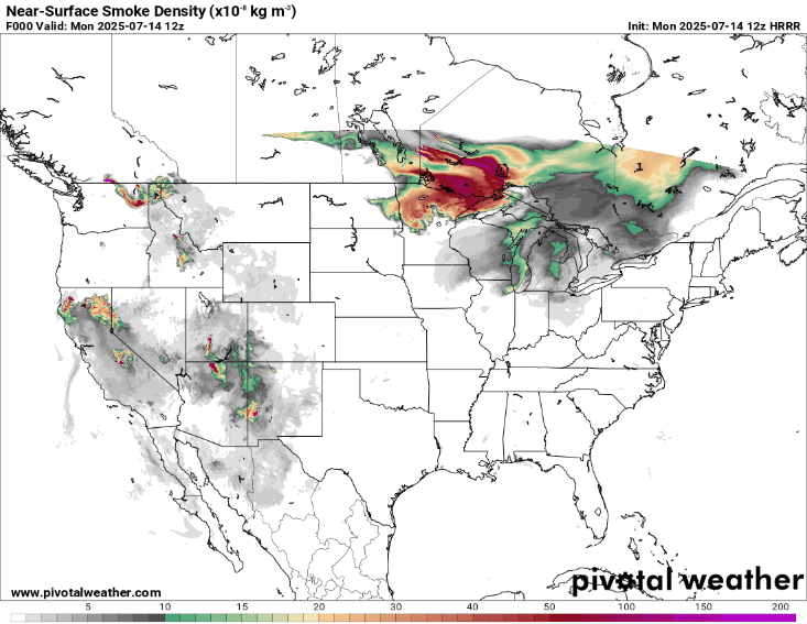
Meanwhile, northwesterly winds continue to bring Canadian wildfire smoke southeast in the upper Midwest and Great Lakes region as shown by this loop of High Resolution Rapid Refresh model forecast of near surface smoke. Air quality alerts are in effect from northern Minnesota east into western New York state. Wildfire smoke will also become an increasing issue for the western half of the country over the next 48 hours, both from fires burning in the region and as northeasterly wind flow brings some Canadian wildfire smoke south into the area.
Those dastardly Canadians sending us their smoke. Didn’t some congress folks just send them a letter asking them not to do that?