
Three children killed on Friday when severe storms capsizes family boat in Wisconsin
More severe storms expected this evening for Independence Day festivities
Hi everyone, please ignore the video e-mail I just sent a bit ago. Even though I recorded a mic check before recording and listened to the start of the recording after I was done, something went awry in the processing and I once again ended up with no audio. My deep apologies — will get this sorted out but rather than going through this again this afternoon, just going to do a quick post about the weather.
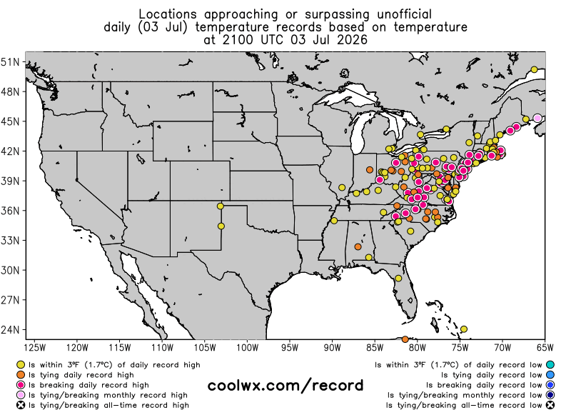
Yesterday was another record breaker as far as heat in the Northeast. The most impressive site as far as max temperatures was Atlantic City, where the airport just west of town recorded 105F, which per the climatologist M. Herrera tied the all-time record. Washington National set an all-time record warm minimum with a low of 84F, and when combined with a daytime high of 102F, Friday was the second warmest day measured by average temperature in Washington, DC ever (records go back to 1871).
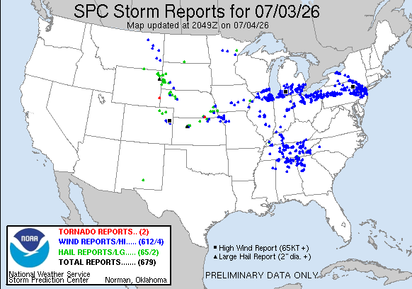
Friday was also an very active day for severe weather, with nearly 700 reports received by the Storm Prediction Center. Multiple clusters of severe storms occurred, but the two most impactful seem to have been ones that tracked from eastern Iowa at midday across the lower Great Lakes region all the way to Pennsylvania by late evening before weakening — and another that tracked from western New York across northeast Pennsylvania and New Jersey.
By late Friday evening, more than 1M customers were without power nationally, most of them in the regions impacted by these two severe weather complexes. As of 4 pm CT, more than 300K customers remain without power in southern Lower Michigan and another 150K in New Jersey, where extreme heat is still ongoing. Even more tragically, three children were killed on Geneva Lake in southeast Wisconsin when severe storms capsized their family boat around midday.
Animation legend: MRMS radar mosaic loop with severe weather reports and warnings overlaid. Brown shaded areas are under severe thunderstorm watches.
Multiple areas will be impacted by clusters of severe thunderstorms this evening, potentially significantly impacting 250th America celebrations. So far this afternoon the most impactful storms have been moving across Missouri, where nearly 100K customers have lost power due to damage to power infrastructure. Other intense severe storms are evolving over parts of the Mid-Atlantic — while these storms should not be well organized, they should produce swaths of 60 to 80 mph winds as they move east into this evening.
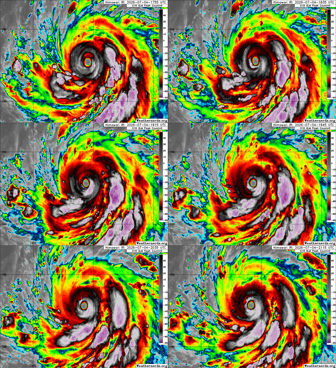
In the Western Pacific, Supertyphoon Bavi went through a bit of a weakening trend the last 12 hours, likely undergoing an eyewall replacement cycle. However, there are some recent signs in infrared satellite trends of a bit of an increasing trend again, and the Joint Typhoon Warning Center forecasts Bavi to reach 160 mph sustained winds by the time it approaches the Marianas Islands late on Sunday (US time).
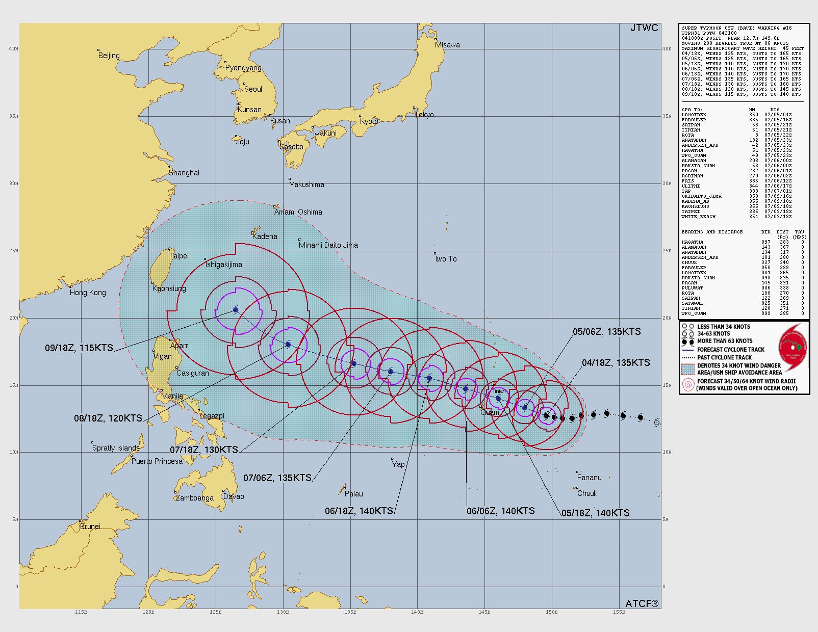
The eye of Bavi is forecast to pass between Guam and Tinian in the Mariana Islands, or very close to the island of Rota. This would place Guam on the “weaker side” with Tinian bearing the right side of the typhoon. This storm will be impacting areas that suffered major damage from Supertyphoon Sinlaku back in April.
Programming Reminder: Given the ongoing active weather, I am utilizing the Substack Chat feature to share periodic real-time updates. I also do occasional live videos to provide briefings and updates about the evolution of severe weather and flash flooding risks. As a reminder, these are benefits that paid subscribers receive for their support of Balanced Weather. Any videos I do will also be recorded and shared to all subscribers. I also provide updates on my BlueSky and Facebook feeds, and via occasional Substack Notes.
Balanced Weather is made possible by the generous support of paid subscribers, who as thanks get access to live Balanced Weather chats and videos as well as the ability to post comments and ask questions on posts. To become a paid subscriber or a free subscriber (also very much appreciated and you will automatically receive new posts in your email), please click below.
I assume maore flooding on Guam given the rain bands...from MRMS (permalink)- https://mrms.nssl.noaa.gov/qvs/product_viewer/index.php?web_exec_mode=run&menu=menu_config.txt&year=2026&month=7&day=5&hour=14&minute=22&time_mode=static&zoom=8&clon=-214.49353027344&clat=13.78946575096&base=0&overlays=1&mping_mode=0&product_type=crefls&product=CREF_MAX&qpe_pal_option=0&opacity=0.6&looping_active=on&num_frames=36&frame_step=200&seconds_step=120