


Special update: Severe weather risk Wed in Pac NW
And an apology :-)
I am starting off this special afternoon Balanced Weather Substack update with an apology. One of my core values as a meteorologist and scientist is to be open and honest about errors and mistakes; in a science as complex as meteorology, and especially given that meteorologists are trying to scientifically predict the future, mistakes and bad forecasts are inevitable. I believe it is incumbent upon us as meteorologists to explain when things inevitably go awry, so that users and customers can see that we are transparent in our communications and that we will use post-mortem analyses to do better next time. I hope to do that consistently with Balanced Weather.
So, now to my apology today: when I was prepping this morning’s newsletter, I was not particularly looking at the Pacific Northwest for severe thunderstorm potential. March is not a typical time for severe weather in the Northwest, and while I did see a marginal risk of severe weather in SPC’s day 2 outlook for Wednesday, I did not do my due diligence and dig into it more closely - and I should have. After seeing Daniel Swain’s BlueSky thread about the risk, I did do a deeper dive - and it is more than worth a post, not just because of the actual risk, but because of the climatological rarity of the setup. (And if you don’t follow Daniel on BlueSky, highly recommend you do if you have any interest in western U.S. weather - he is deeply knowledgeable on the intricacies of the complex meteorology of the region.)
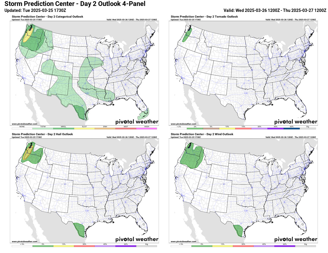
Since the morning newsletter, SPC issued their updated day 2 severe weather outlook, and upgraded western Oregon and Washington to a slight risk (level 2 of 5) of severe storms, primarily for large hail. The hail outlook in the lower left image shows a hatched area, which means there is at least a 10% risk that if severe hail occurs within 25 miles of a given point it will be significant severe hail, defined as 2” or greater in diameter.


Severe weather is overall pretty rare in the Pacific Northwest, but to give you some idea of just how rare getting 2” hail would be, I went to the Storm Data database kept by the NOAA National Centers for Environmental Information and searched for 2” hail reports in Washington and Oregon back to 1950. There are a total of 27 reports in the 75 year period, and only one - a random 2” hail report from Seaside, OR in January 2018 - is from western Washington or Oregon. All of the rest of the reports are from the eastern parts of the state where supercell thunderstorms are somewhat more common during the summer months. (As an aside for fun comparison, when I do the same query in Storm Data for 2” hail reports in Oklahoma, I can only get data to load from 1950 to 1980 before it tells me that 500 reports is all it can produce in one query.)

So what is happening meteorologically to create such a rare environment? First, a strong weather system in mid and upper levels will be moving into the Pacific Northwest Wednesday afternoon and evening, providing forcing for thunderstorm development as well as increasing wind shear that will help support severe thunderstorms.

Along with the record warmth that we’ve discussed in earlier posts, moisture in lower levels of the atmosphere is also forecast to be unusually high. Models are showing upper 50s to lower 60s dewpoints in the area west of the Cascades, which when combined with cold temperatures aloft with the upper trough and the low level record warmth results in an unusually unstable atmosphere for the region.

This model forecast upper air sounding shows this instability, with the convective available potential energy (CAPE) value at the surface of about 2000 J/kg. This would be an impressive value for a March severe weather setup in the Southeast, let alone the Pacific Northwest. I have highlighted a couple of parameters from the supplemental data at the bottom of the chart that are particularly interesting. First, the values in the right yellow box are the wind shear parameters for various layers of the atmosphere as listed to the left. The top one, surface to 6 km, is a commonly used parameter for forecasting severe storms, and a value of 53 kt is indicative of the potential for supercell thunderstorms (30 to 35 kt is the typical threshold), assuming sufficient instability. The other parameter highlighted in yellow to the left combines the wind shear and instability into a single parameter, the Craven-Brooks Significant Severe Parameter. Values of 20,000 for this parameter are indicative of potential for storms that can produce significant severe weather, and clearly that is exceeded here.

All of the meteorology discussed here suggests that rotating, supercell thunderstorms are very possible in the western Oregon and Washington region Wednesday afternoon, and the high resolution storm scale models are explicitly forecasting such development. The graphic above shows the updraft helicity forecast - essentially, showing mid level rotation swaths from thunderstorms the models forecast - from all of the models that make up the High Resolution Ensemble Forecast (HREF) system. Several of the models are indeed showing rotating supercell storms. Rotating supercells are much more likely to produce larger hail than ordinary, single cell storms, and given all of the favorable environmental factors, it is apparent why SPC has forecast a risk for very large hail. Given the presence of rotating supercells and the relatively high low level moisture, there is also at least a low risk of tornadoes which is also shown in the SPC day 2 outlook above.
Obviously, whether or not the atmosphere actually produces supercells with large to very large hail remains to be seen. But even the fact that the atmospheric setup exists for it to be possible in late March in the Northwest is highly unusual; if we actually get reports of 2” or greater hail from the region tomorrow, it will truly be rarified air.