


Special BalancedWx Update: NWS announces reduction in upper air flights
Reduction is on top of previously announced cuts
With the issuance of a couple of public information statements this afternoon, the National Weather Service announced the reduction of upper air weather balloon flights at several locations around the country. The NWS is completely suspending flights at Omaha, NE and Rapid City, SD; flights are being reduced from twice per day to once per day at the following locations:
Aberdeen, SD
Grand Junction, CO
Green Bay, WI
Gaylord, MI
North Platte, NE
Riverton, WY
In the statements, the NWS makes clear that these reductions are “due to a lack of Weather Forecast Office (WFO) staffing.”

The National Weather Service collects upper air weather data through the release of weather balloons carrying an instrument known as radiosondes. Under normal NWS operations, upper air soundings are released twice per day at 100 sites across the country as shown above. The releases all occur at the same time not only within the United States but globally - 0000 UTC and 1200 UTC - to ensure that the data is collected at the same time for use in numerical weather prediction computer models.
The NWS has already announced reductions in upper air data collection in recent months due to a variety of issues, including staffing and lack of access to helium. With these new staffing related reductions, the upper air network is now becoming increasingly degraded as shown by below in a map put together by my colleague Chris Vagasky.
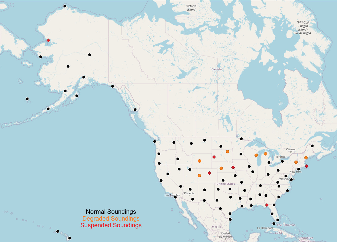
There are now six upper air sites where no operations are occurring, and another eight locations where upper air soundings have been reduced in frequency.
The impact of losing sounding data on computer model forecasts is a topic of ongoing research and discussion within the meteorological community. Computer model forecasts have become less reliant on soundings over the last couple of decades due to improvements and increased availability of aircraft measurements and remote sensing data (e.g., satellite data) that can be used effectively in model data assimilation systems. Even with these advances, sounding data is still needed to provide measured data that can be used to calibrate and “anchor” satellite data retrievals, and a published paper in 2010 found that upper air radiosonde data was at that time still the second most important data source for forecast model accuracy behind aircraft data.
Of even more concern to me, as you can see on the map above certain areas will be impacted more negatively than others. There is now a large swath from the central Rockies into the upper Midwest and Great Lakes region as well as parts of the Northeast that will have significantly degraded upper air data for the foreseeable future. Having degraded data over areas that large likely makes the possibility of associated errors in model forecasts greater than if the degraded sites were more randomly spread out. Regardless of the impacts on model forecasts, upper air data is used extensively by public and private sector meteorologists for a variety of crucial forecasting applications, especially in forecasting severe thunderstorms and winter weather. Degraded upper air data will likely negatively impact the meteorological community’s forecast and warning capabilities in those areas.
While from all initial indications the NWS performed well with forecasts and warnings for the significant severe weather, fire weather and wind events of the last week, these latest reductions in NWS services due to lack of staffing are very concerning. This is especially true given that the Department of Commerce, NOAA/NWS’ parent cabinet department, just offered a new voluntary early retirement authority (VERA) and associated voluntary service incentive payment (buyout, VSIP), with employees who take this offer required to be out of federal service no later than May 3. Obviously, the number of NWS employees who will take this offer is unclear at this point, but it seems certain that NWS staffing issues will only grow in the coming weeks, as we get deeper into severe weather season and approach the start of the 2025 hurricane season on May 15.
Thanks to Chris Vagasky and Kelton Halbert for sharing information used in this post.
The map does not include a dot for the Bethel, Alaska (70219) RAOB site, which is still active.
Chatham, MA has been decommissioned, not just suspended. https://www.weather.gov/media/box/Chatham_Closure.pdf