
Special BalancedWx Update: NOAA statement about impacts of NWS staff reductions
And a quick evening severe weather update
NBC News led their Nightly News broadcast this evening with a story about the severe weather impacting the country this weekend and the impacts on Spring Break and Easter travel. As part of the story, they talked about the impacts of staff reductions to the National Weather Service, focusing on the reduction of twice daily weather balloon flights. The NWS announced on Thursday additional reductions above and beyond ones that had already been announced in the last several weeks.
As part of the story, my meteorologist colleagues Chris Vagasky and Nick Bassill were interviewed about the potential negative impacts of the data lost by the reductions in balloon flights. After they commented about the potential loss of forecast accuracy and detail from the reduction in data, the reporter read a statement provided by NOAA about the NWS reductions in staff.
Through strategic transformation, staff reallocation, and updated service standards, NWS is ensuring resilience and continuity of mission-critical functions. Reports suggesting otherwise are false and disrespectful.
I will cut to the chase: in my opinion, this statement is a nonsensical string of buzzwords and in and of itself disrespectful to the remaining staff of the National Weather Service and to the broader meteorological community. As I discussed in my original article in March about the reduction of upper air flights, the potential negative impacts of these reductions are definitely not clear-cut and will vary depending upon the weather situation.
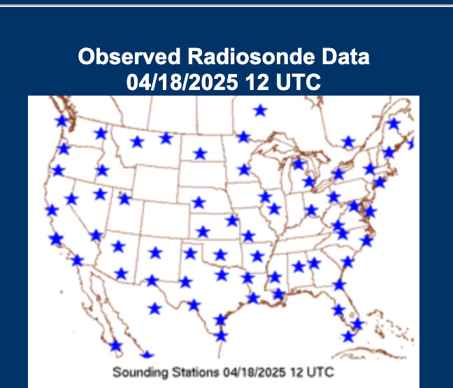
Having said this, this is a map of the upper air flights that were conducted on Friday morning from a post by my colleague Noah Brauer. There is a clear and obvious gap in data over Colorado, Wyoming, and South Dakota, as well as in eastern Nebraska and Iowa. While upper air flights can be missed for a variety of reasons (for example, a flight appeared to be missed this morning at Dallas-Fort Worth because of thunderstorms in the area), all of the upper air sites in Friday’s region of missing data were previously announced as being impacted by reduced staffing, so it is safe to assume staffing is the cause here. Again, while the exact amount of degradation is up to debate, I feel entirely confident in saying there was some degradation to NWS services due to that much missing upper air data. This is especially true given that there was ongoing, impactful severe and winter weather both in and downstream of the area of missing data.
Based on my long experience in NOAA and NWS, I have utmost confidence that the remaining staff in the NWS is doing everything in their power to try to reduce those negative impacts, and other potential negative impacts from staffing reductions. In fact, I have had conversations with former NWS colleagues in recent weeks in which they have relayed to me actions being taken such as staff working overtime, offices sending staff from offices with more staffing to those with less staffing, and prioritization of duties. However, these are simply stopgap actions to try to minimize impacts, not eliminate them.
NWS is being decimated by staffing shortages caused by the government wide hiring freeze combined with the loss of staff due to the “Fork in the Road” and the most recent agency wide Voluntary Early Retirement/Voluntary Separation Incentive Program. These are staffing actions that are inherently not strategic; they make no effort to try to prioritize more critical positions or protect offices with greater shortages. This is how some offices end up being more than 40% short of staff and needing to reduce services while others are faring better.
As an example of what is happening to NWS, my understanding from multiple sources is that the NWS office in Houston - one of the largest metropolitan areas in the country with tremendous vulnerability to hazardous weather - will soon be without any permanent management staff: their meteorologist-in-charge, warning coordination meteorologist, science and operations officer, and electronics system analyst will all be retired by the end of April. While I have no doubt that remaining NWS leadership will do what they can to mitigate the impacts of this situation, there is clearly nothing “strategic” about leaving this NWS office in particular without any permanent managerial staff as we approach hurricane season.
I want to make clear again my total respect for the remaining NWS staff that I feel sure are doing everything in their power to try to provide the best services possible to the nation. Based on my own experience as a scientist and a long time former NOAA employee, I will continue to honestly provide my perspectives on what is happening to the meteorological enterprise due to the budget and staffing decisions being made for NOAA.
Quick evening weather update

Since I am sending out a post to discuss this other news, I want to quickly provide an update about ongoing weather this evening and into the overnight. Severe weather watches and warnings are in effect across parts of central and northern Texas and southern Oklahoma this evening. Several tornadoes have occurred in this region, along with a number of reports of large hail, in some cases larger than 2” in diameter. Conditions are expected to remain favorable for severe weather in this region for the next several hours, with the risk expanding into eastern Oklahoma, western Arkansas and southwest Missouri.
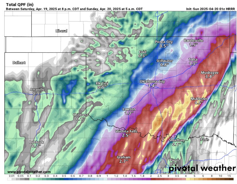
In addition to the severe weather risk, thunderstorms moving repeatedly over the same area will bring very heavy rainfall with the potential for localized bands greater than 5” over the next several hours. Hence, the risk for flash flooding will also be increasing over the same region through the overnight hours.