


Significant heavy rain and flash flooding in North Carolina from Chantal
Busy severe weather day expected in the central United States
I said in my post yesterday about the Texas Hill Country tragedy that I will be transparent about mistakes - I was talking about my thoughts and perspectives on that event, but it also applies to forecasts and my general commentary. I am here this morning to admit that the heavy rainfall and flash flooding in North Carolina from Chantal was more extensive than I anticipated.

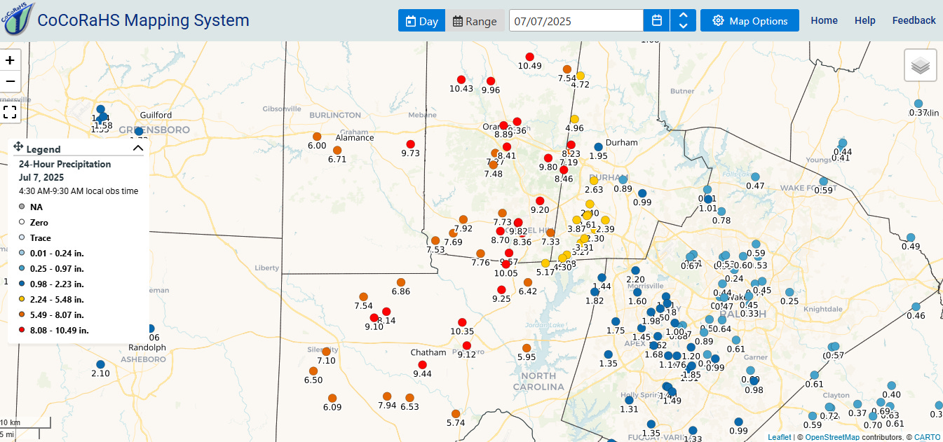
The Multi-radar Multi-sensor (MRMS) 24 hour precipitation estimate ending at 7 am ET this morning showed a band of 2+” of rain across central North Carolina, with a narrower band of 5-10” within this band. The heaviest rain fell just west of Raleigh-Durham, with several CoCoRaHS citizen rainfall network gages reporting 9-11” of rainfall.
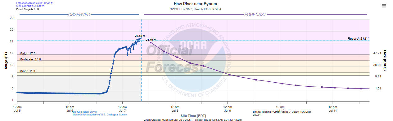
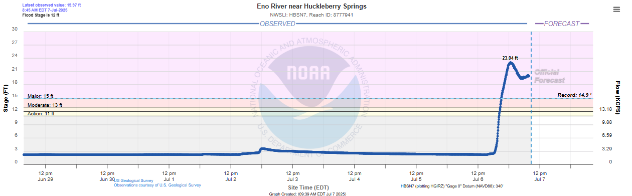
Not surprisingly, this resulted in major flash and river flooding, with both the Eno and Haw Rivers setting all-time record crest levels. The Eno River at Huckleberry Springs crested at 23.04’, more than 8’ above its prior record set in 1989. This of course resulted in major impacts, with evacuations and water rescues reported from the region and numerous structures and homes flooded.
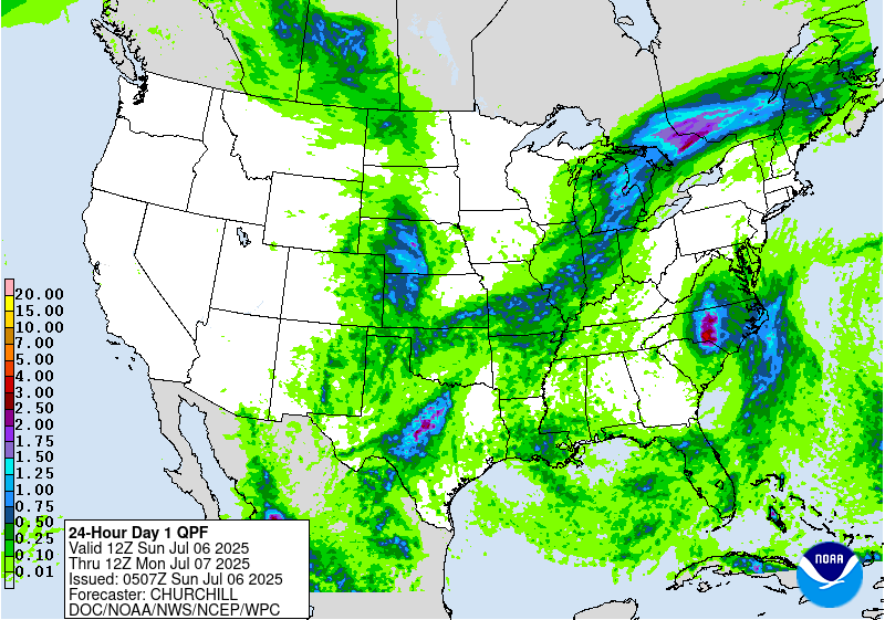
To give you some perspective of just how much the observed rainfall exceeded the forecast rainfall, this is the NOAA Weather Prediction Center forecast day 1 rainfall for the same period as the observed map above. This forecast was based on the weather models from Saturday night. You can see that it is only showing widespread 1-3” amounts. Unlike the heavy rainfall events in central Texas the last few days which were driven by individual thunderstorm complexes that produced localized intense rainfall totals, the rainfall in North Carolina was more widespread and over a larger area and associated with a well defined tropical cyclone, so it is more surprising to me that the models failed to resolve and forecast it better.

Looking back through the models, the only model that I have found from Saturday evening that seemed to get close to the actual rainfall was the European Centre (ECMWF) model, which showed a band of 5-8” in the region. A quick glance suggests that this model may have better captured the upper level winds north and northeast of Chantal which affected how the rainfall evolved. I will be looking at this more closely and will share whatever I find of interest.

Chantal has weakened quite a bit since last night, but should still produce some locally heavy rainfall and potential flash flooding along the Delmarva coastal region today. Additional slow moving thunderstorms in an unusually moist environment could also cause heavy rain and flash flooding along a slow moving cold front from the Northeast to the Mid-South. A particular concern area is from eastern Ohio into western New York where recent wet conditions could mean more runoff from heavy rain, exacerbating flash flood concerns.
Unfortunately, the heavy rainfall threat in central Texas does not want to go away. The remnant weather disturbances from this weekend’s thunderstorm activity have weakened less than the models have been forecasting, and given unusually high levels of moisture persisting across the region, bands of heavy thunderstorms will likely continue to produce swaths of localized intense rainfall through tonight. The Weather Prediction Center recently upgraded portions of central Texas to a moderate (level 3 of 4) risk of excessive rainfall through tonight. Obviously given all of the disastrous rainfall and flooding over the last few days, any additional rain and flooding is a big concern. The most recent media reports put the death toll from the horrific flash floods at 82 with a number of people still missing, and obviously additional rainfall only hampers rescue and recovery efforts.
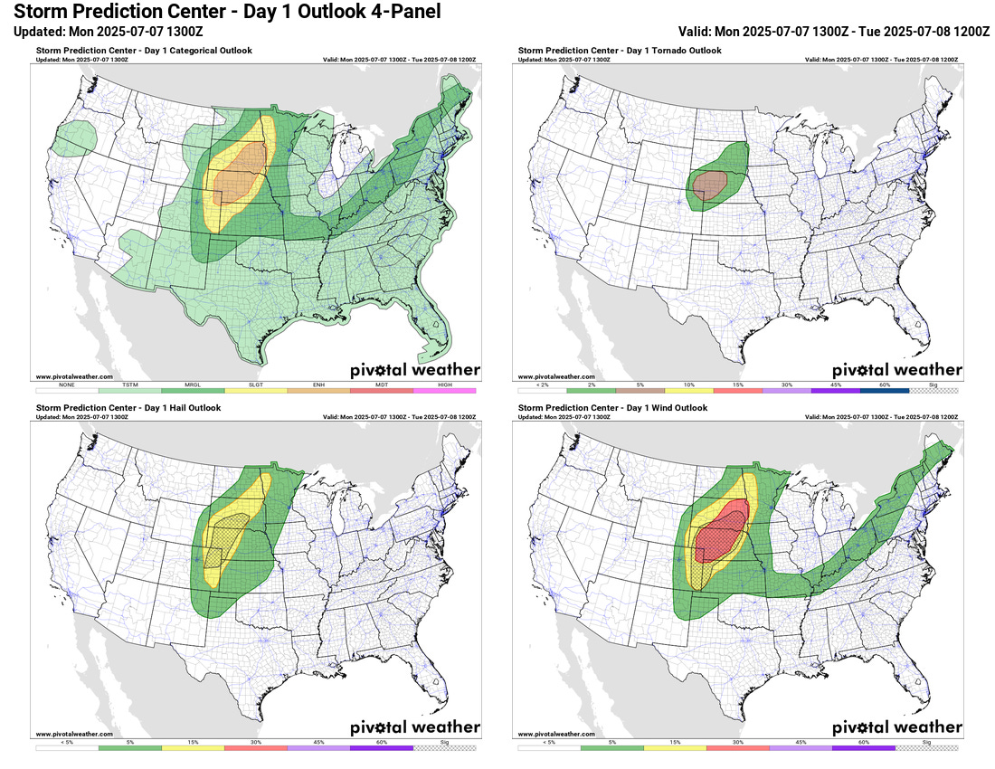
Today is also expected to be an active severe weather day across the central part of the country. The atmosphere is expected to become quite unstable across the central High Plains, and supercell thunderstorms capable of producing very large hail and tornadoes should develop from northeast Colorado into southwest South Dakota. These storms will likely evolve into a complex of severe storms that could produce widespread, significant wind damage as it moves east and northeast tonight. A large enhanced (level 3 of 5) risk of severe storms is in place in this region. A few strong to severe storms are also possible along the cold front from the Northeast to the Mid-South.
Given the potential for active weather in different parts of the country this afternoon and evening, I may do some video and/or live chat updates depending on how things evolve. As a reminder, these are paid Balanced Weather subscriber benefits. I want to thank the many people who have become new subscribers - both paid and free - to Balanced Weather over the last few days. I continue to be devastated by the catastrophic events in the Hill Country of Texas, and hope that Balanced Weather can serve to be a reasonable voice to help people understand these sorts of events from a fact and experience based perspective.
I live just a few miles east of the worst of the flooding in North Carolina. I was watching the deepmind cyclone link you mentioned a while back, the T.io weather app - which showed the cone and storm track, plus my Tempest home weather unit in our pasture. The deepmind predicted the track more accurately. The actual track continuously moved west of the projected T.io track. The rainfall amounts were not close on anything I was seeing. The heaviest rain fell in the final rotation of the event after 6:00 pm. Prior to that we had 2.06 inches in the pasture. In the following 4 hours the total went to 7.6 inches. Two hard waves of the backside rotated over us. The Mebane and Burlington areas were harder hit by these final rotations.