


Severe weather outbreak hits upper Midwest
3 killed in North Dakota tornado
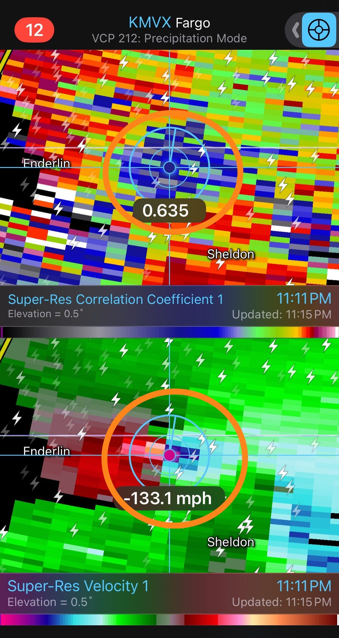
A major severe weather outbreak developed Friday evening in North Dakota. An extremely intense bow echo complex of severe storms evolved during the evening along the Montana/North Dakota border and moved rapidly east. Meanwhile, tornadic supercells developed in eastern North Dakota ahead of the bow echo, and moved east along and south of Interstate 94, producing a number of tornadoes. The radar image from above is when an intense tornado was produced by a supercell between Enderlin and Sheldon, ND.
The radar signature and morning damage images suggests this was an intense, potentially violent tornado. In the image above, the bottom panel is base velocity and it shows that gate-to-gate rotational velocity - the maximum difference in velocity between two adjacent radar bins divided by 2 - exceeded 100 mph which is extremely strong. The top panel is correlation coefficient (CC), a dual polarization product which essentially tells the meteorologist the difference in sizes and shapes of the particles being detected by the radar; the large area of blues and gray pixels in the center of the image show low values of CC colocated with the strong rotation, indicative of a large airborne tornadic debris field.

Morning images show that houses were completely destroyed and train cars were derailed and moved rather significant distances through farm fields by this tornado. Unfortunately, at least 3 people were killed by the tornado and per my NSSL colleague Dr. Tony Lyza, this is the first multi-fatality tornado in the state of North Dakota since 1978.
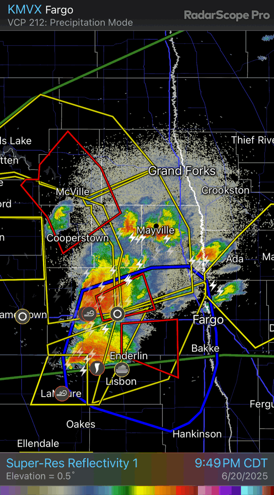
Shortly after this tornado, the bow echo caught up to the supercells and merged with them, as shown in this radar image above.
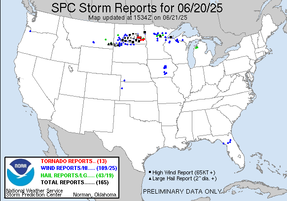
After this evolution, the storms reorganized and produced additional widespread damaging winds across north central and northeast Minnesota, northern Wisconsin, and into the western Upper Peninsula of Michigan. More than 100 incidences of straight line wind damage and severe wind gusts occurred with this complex of storms from its start along the Montana/North Dakota border region, including more than two dozen significant (75 mph or greater) wind gusts. This included multiple measured wind gusts greater than 90 mph across North Dakota, with the highest reported gust so far being 101 mph at a North Dakota Agricultural Weather Network (NDAWN) station near Temvik.

The storm complex has weakened somewhat this morning, and is now in the eastern Great Lakes region. This region is anticipated to be the main focus for any severe weather risk today, either from some reintensification of the overnight storm complex or new storm development.

A more significant risk of severe weather is expected to develop over the Upper Midwest on Sunday as another disturbance moves into the region and interacts with an extremely unstable airmass on the northwest side of the building eastern US heat dome. The focus for this event looks to be from the eastern Dakotas across northern Minnesota and adjacent portions of Wisconsin and the UP of Michigan. Very large hail and tornadoes are possible with the initial storm development, but eventually a complex of storms capable of significant, widespread wind damage could evolve again and move east across the region.

Speaking of the eastern United States heat dome, little has changed with the expectations for this high impact weather event. Near record heat combined with oppressive humidity will spread east from the Midwest into the Northeast and Mid-Atlantic region over the next couple of days. It still looks like Tuesday will see the peak of the heat dome with numerous record high temperatures expected and widespread extreme heat risk. While the upper level high pressure system will weaken a bit after Tuesday and some cooler air will infiltrate into the Great Lakes and potentially New England, the overall weather pattern of a large upper level high pressure area centered over the Mid-Atlantic and Southeast will continue through the end of the week. This will mean an unusually prolonged period of extreme heat and humidity for this region.
As the upper level high weakens and a cold front works into the Great Lakes, the threat of severe weather will shift east Monday and Tuesday. After Tuesday, the pattern becomes more uncertain but given the anticipated heat and instability, there will likely be some severe weather risk over parts of the northeast quarter of the country.
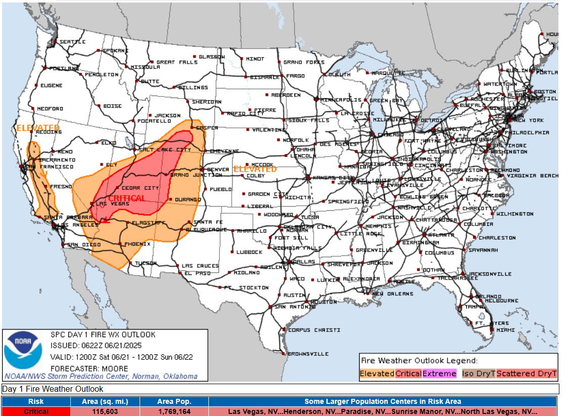
Meanwhile, upstream of the eastern US heat dome, a trough of low pressure is developing over the western United States. While this will bring some relief from recent record heat, strong winds and dry conditions associated with the trough are bringing dangerous fire conditions to the Great Basin and Intermountain West. Numerous new wildfires have developed across the region in the last couple of days, including the Forsyth Fire in southwest Utah which destroyed a number of homes.

On the eastern side of the trough, monsoonal moisture will continue to work north across parts of New Mexico and far west Texas, resulting in scattered thunderstorms capable of localized flash flooding.