
Severe thunderstorms hammering parts of the Midwest and Ohio Valley today
More than 500K customers without power at midday due to storms. Also - Trump Administration announces termination of support for Arctic Report Card.
Starting off this morning’s newsletter with some federal science news. The scientists responsible for preparing NOAA’s annual Arctic Report Card were informed yesterday that the Trump Administration is ending support for the project after two decades. The Arctic Report Card is a peer-reviewed report detailing the climate trends in the critical Arctic region — a part of our planet shown to be warming at a much more rapid pace than the rest of the globe.
While scientists from across the atmospheric science community participate in construction of the report, NOAA scientists coordinated it and the agency provided support for production of the report, hosted it on the NOAA website and helped ensure its results were widely shared publicly. As CNN’s Andrew Freedman reported, the 2026 version of the report is already in progress, and “it is now up to the lead authors, together with chapter authors and other subject matter experts involved with it, to try to figure out how to still carry it forward.” He also noted:
The withdrawal of support for the Arctic report continues the Trump administration’s pattern of canceling climate programs, distorting the science and restricting the public’s access to it.
For example, NOAA no longer produces an annual report on billion-dollar disasters or updates that database. It also dismissed all the authors working on the Congressionally mandated National Climate Assessment to start anew with its own set of authors who have questioned or rejected some of the widely accepted scientific findings on human-caused climate change.
The administration also halted updates to climate.gov, providing no new official information there on everything from El Niño to global warming.
Support for the climate.gov website was picked up by the broader community and non-profit groups, led by former members of the NOAA Climate.gov team, while the billion-dollar disasters project was continued by Climate Central and the same lead scientist that led by the project at NOAA. Hopefully, a similar solution can be found for the Arctic Report Card.
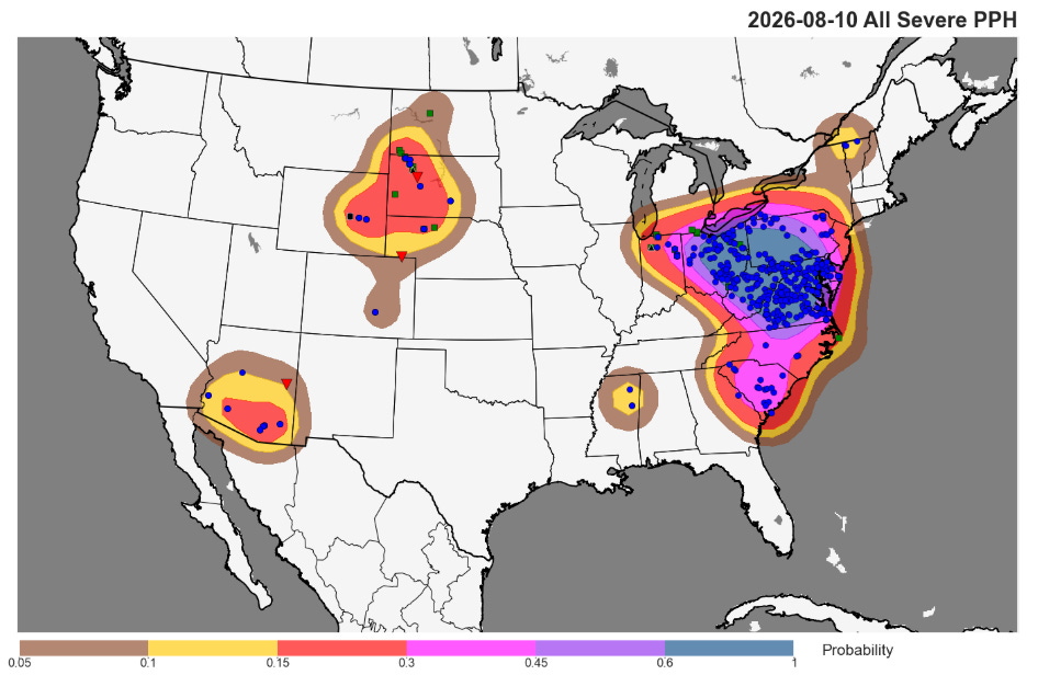
Turning to weather, as expected Monday was a busy day of severe thunderstorms, with more than 600 reports of severe weather received by the Storm Prediction Center. The most focused area was in the Mid-Atlantic and Upper Ohio Valley region, where more than 250,000 customers were without power at one point yesterday evening due to the storms.
I had posted late last evening about the increasing potential for an intense complex of storms to develop overnight across South Dakota and Iowa. While the evening high resolution models had a strong signal for said development, it never really panned out — the Storm Prediction Center issued an excellent meteorological discussion outlining the uncertainty surrounding the evolution of the storms. The many atmospheric factors that come into play with severe thunderstorms are why we have to use probabilistic approaches to forecast their hazards — even when there are many favorable parameters, small scale features can derail the development of severe storms.
As I talked about in yesterday’s newsletter, conditions today are very favorable for severe thunderstorms from the lower Great Lakes across the upper Ohio Valley and Appalachians — and so far, the atmosphere is taking advantage of those favorable conditions.
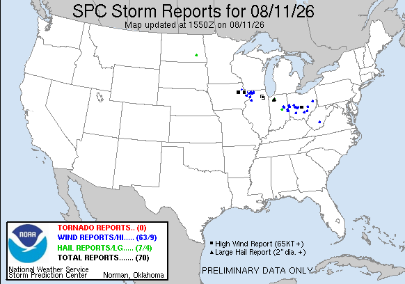
There have already been 70 reports of severe weather since 7 am CT, including multiple reports of baseball sized hail across east central Indiana and several measured wind gusts greater than 80 mph. This includes an 82 mph gust at Port Columbus International Airport just east of Columbus — this is the highest wind gust ever recorded at this location and the second highest on record in Columbus (per NWS info). An 85 mph gust was measured at the Aurora, IL airport as the severe storm complex currently moving into northwest Indiana moved through northern Illinois. More than 500,000 customers are without power at midday across Illinois, Indiana and Ohio and parts of the Appalachians due to these storms (data from PowerOutage.us).
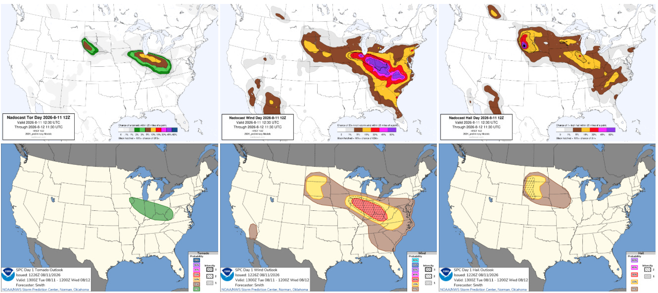
Intense complexes of severe storms are expected to continue moving southeast this afternoon and tonight along the edge of the hot, humid airmass dominating the central part of the country. A large enhanced (level 3 of 5) risk of severe storms is in place from northern Illinois into the central Appalachians as storms with significant straight line winds (gusts greater than 80 mph possible), large hail and a few tornadoes are expected.
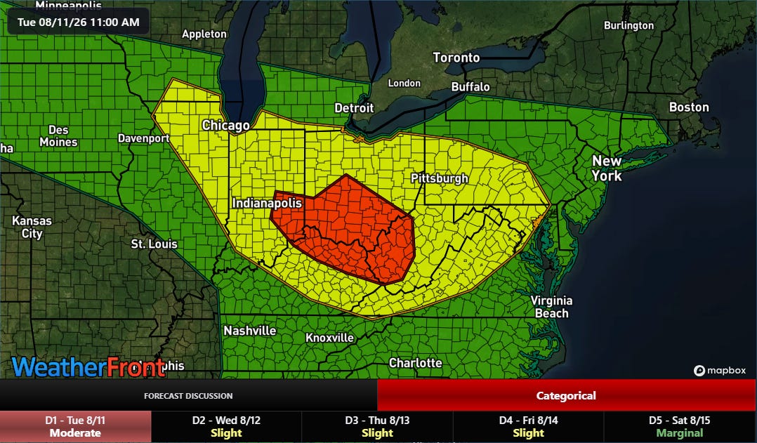
Multiple rounds of storms with torrential downpours will also lead to areas of potentially significant flash flooding. The NWS Weather Prediction Center has a moderate (level 3 of 4) risk in place for a large part of the upper Ohio Valley.
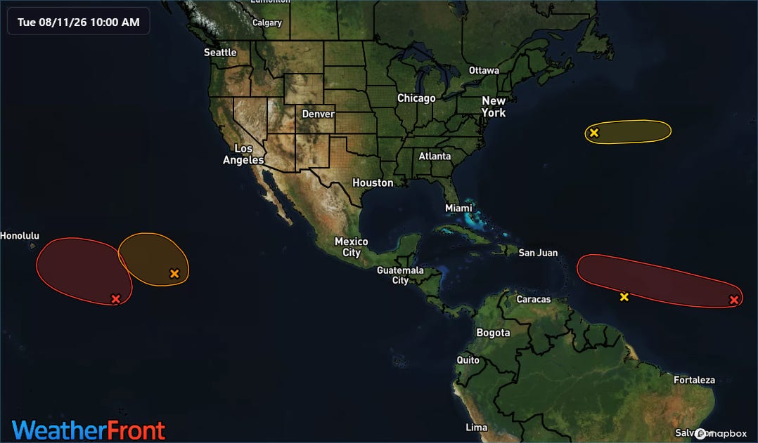
Turning to the tropics, the National Hurricane Center now has two disturbances with high (70-90%, red areas in map above)) probability of developing into a tropical cyclone over the next week — one in the central Atlantic and one in the central Pacific.
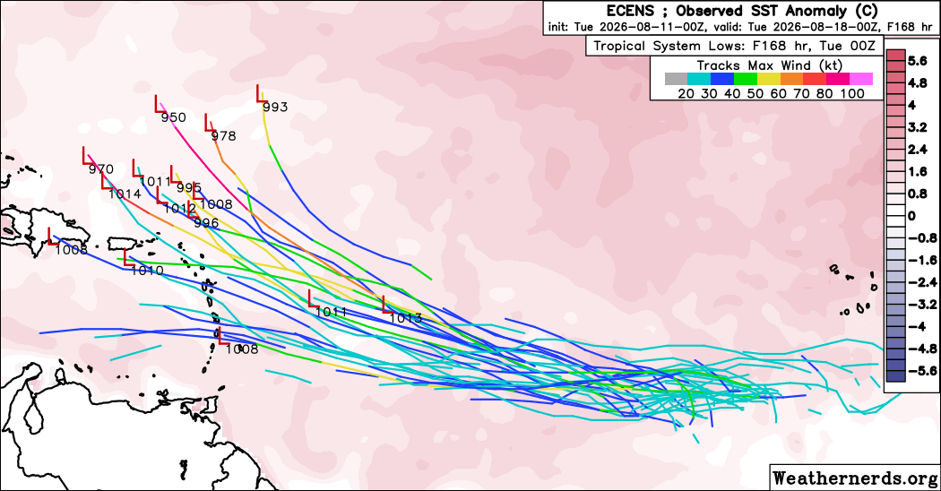
There is still plenty of uncertainty with the Atlantic system, as the atmosphere is only marginally supportive and the models are showing mixed signals. The European ensemble (above) is quicker to move the system west, with several members of the ensemble showing an organized system passing near or northeast of the islands of the far northeast Caribbean.
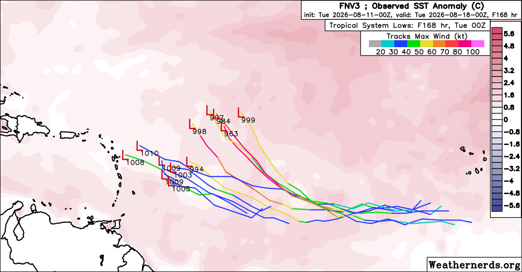
The Google DeepMind (GDM) AI system is generally slower to develop a system and move it west, with only about 10 members having a well organized system somewhere east of the Caribbean by early next week. Plenty of time to watch this — and as of now the risk of any impacts to land seems relatively low.
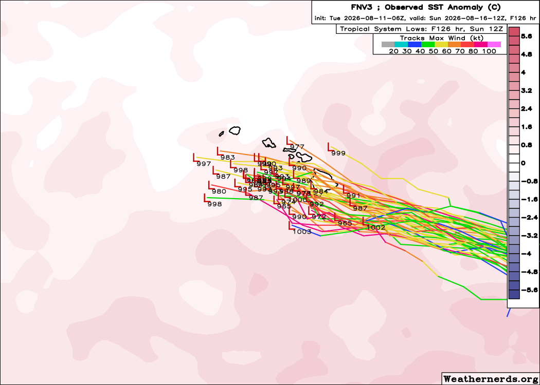
The system over the central Pacific is of much more immediate interest for impacts. The latest GDM forecast shows a concerning scenario for Hawai’i, with a potentially strong tropical storm or hurricane approaching the state from the east-southeast by this weekend on a track that could bring significant impacts.
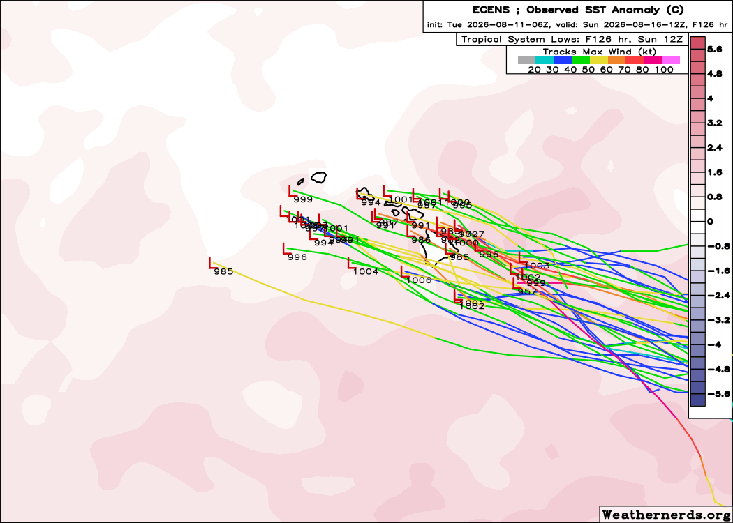
The European ensemble is a bit less bullish — but has also been showing a track that is generally a bit farther north than the GDM. Regardless of the exact forecast, this is clearly a system that needs to be monitored for Hawai’i — and I will have some deeper dive information on this the next couple of days in later posts or videos.
Programming note: Given the active weather expected this week, I will likely be doing some occasional live videos and Substack chats. As a reminder, participating in these live events is a benefit that paid subscribers receive for their support of Balanced Weather.
Balanced Weather is made possible by the generous support of paid subscribers, who as thanks get access to live Balanced Weather chats and videos as well as the ability to post comments and ask questions on posts. To become a paid subscriber or a free subscriber (also very much appreciated and you will automatically receive new posts in your email), please click below.
If we’re pulling back on the Arctic, then will we also cancel the ($4b) order for new icebreakers? As with so much from this “administration”, incredibly myopic.