


Record South Texas rains and flooding - and NWS organizational changes
March 27
Happy Friday! Before we get into actual weather today, I want to give some perspective on a story that was reported in the media last evening about the National Weather Service announcing organizational changes yesterday. A number of potential changes to the NWS have been rumored in the weather community in recent weeks in response to staffing reductions and executive order mandates for agencies to develop reorganization plans. The changes discussed in this article were ones that have been strongly rumored: the merger of the Weather Prediction Center (WPC) and the Climate Prediction Center (CPC), and the merger of the Environmental Modeling Center (EMC) and the Meteorological Development Lab (MDL).
As someone who has been in leadership positions within NOAA in both the National Weather Service and NOAA Research for more than two decades, I hopefully have a somewhat unique perspective (and admittedly strong opinions) about the organization of NOAA’s weather entities. I am sure that I will unfortunately have many more opportunities to discuss these perspectives and opinions in the coming weeks and months given the changes happening in the federal government right now. For now, a quick summary of my views is this: I strongly believe that the NWS has been organizationally dormant for way too long, and that significant reorganization is needed to create an agency that can truly meet society’s needs for the future. However, I do think NWS was starting down this reorganization road on its own in recent years - and clearly, the current haphazard and draconian way in which changes are being forced upon the federal government in general, and NOAA and NWS in particular, are completely counterproductive to evaluating and making the changes that are truly needed.
With that overall perspective shared, I will say that am not particularly concerned about the specific organizational plan to merge CPC with WPC and MDL with EMC. There is sufficient overlap with the missions of these entities that I would not expect the organizational changes to cause serious degradation of services. Of much more concern to me is the reason these changes - and other changes not discussed in this article that will likely become clear in the coming days - are necessary, namely the staff reductions that have already occurred and those still to follow. The manner in which staff reductions are taking place - namely, removing probationary employees and incentivizing retirement/resignations - means that the reductions are occurring with almost no focus on the programs or functions being reduced. It also means that a large number of experienced, senior employees and leaders are leaving the agency all at one time, again with no accounting for the programs affected.
Until we know the full numbers of staff reductions and NWS plans to organize around the reduced staffing, it is hard to comment intelligently on the potential impacts. However, given the numbers of staff being discussed and the manner in which it is happening as I discussed above, I am very concerned that rather than NOAA/NWS being able to make the smart changes that have really been needed for a number of years, they will be forced into suboptimal organizational decisions based primarily on staffing and budget constraints. Obviously, I am also extremely concerned about the reduced staffing’s impacts on current critical services, not only through direct reduction of human resource capacity but also the serious negative impacts of increased stress and reduced morale of the remaining employees.
Unfortunately, as I alluded above, I am sure this will be many more future opportunities to discuss these topics in future posts. Feel free to comment or ask questions in the comment section below.
South Texas Record Rains and Flooding
We discussed in yesterday’s newsletter the anticipated heavy rains and potential flash flooding in deep South Texas - and the atmosphere (unfortunately) delivered.
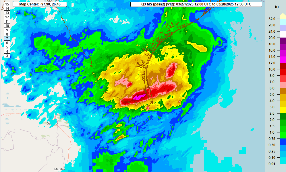
The 24-hour MRMS estimated rainfall ending at 7 am CT this morning shows widespread 2.5+” rainfall amounts over the region, but training thunderstorms in the RGV caused a focused band of 7 to as much as 14” of rain. The maximum amount appears to have been just about right on top of the Harlingen airport, which reported a daily rainfall total for Thursday of 13.79”, which set an all-time record for daily rainfall (previous record was 10.64” sent July 26, 2020; records at Harlingen go back to 1952). Significant flash flooding with numerous flooded structures and water rescues were reported due to the intense rainfall; videos from the area show vehicles abandoned on flooded highways and interstates. This CNN article is a good summation of the impacts to the region.

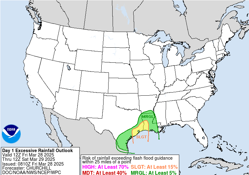
Luckily, it looks like the heaviest rains are starting to shift east of this region today, with the heavier rains expected in southeast Texas and southwest Louisiana. While the extreme rainfall that was seen in the RGV in not anticipated farther east, WPC has outlooked the region in a slight (level 2 of 4) risk of flash flooding for today.
Severe weather risks ramping up
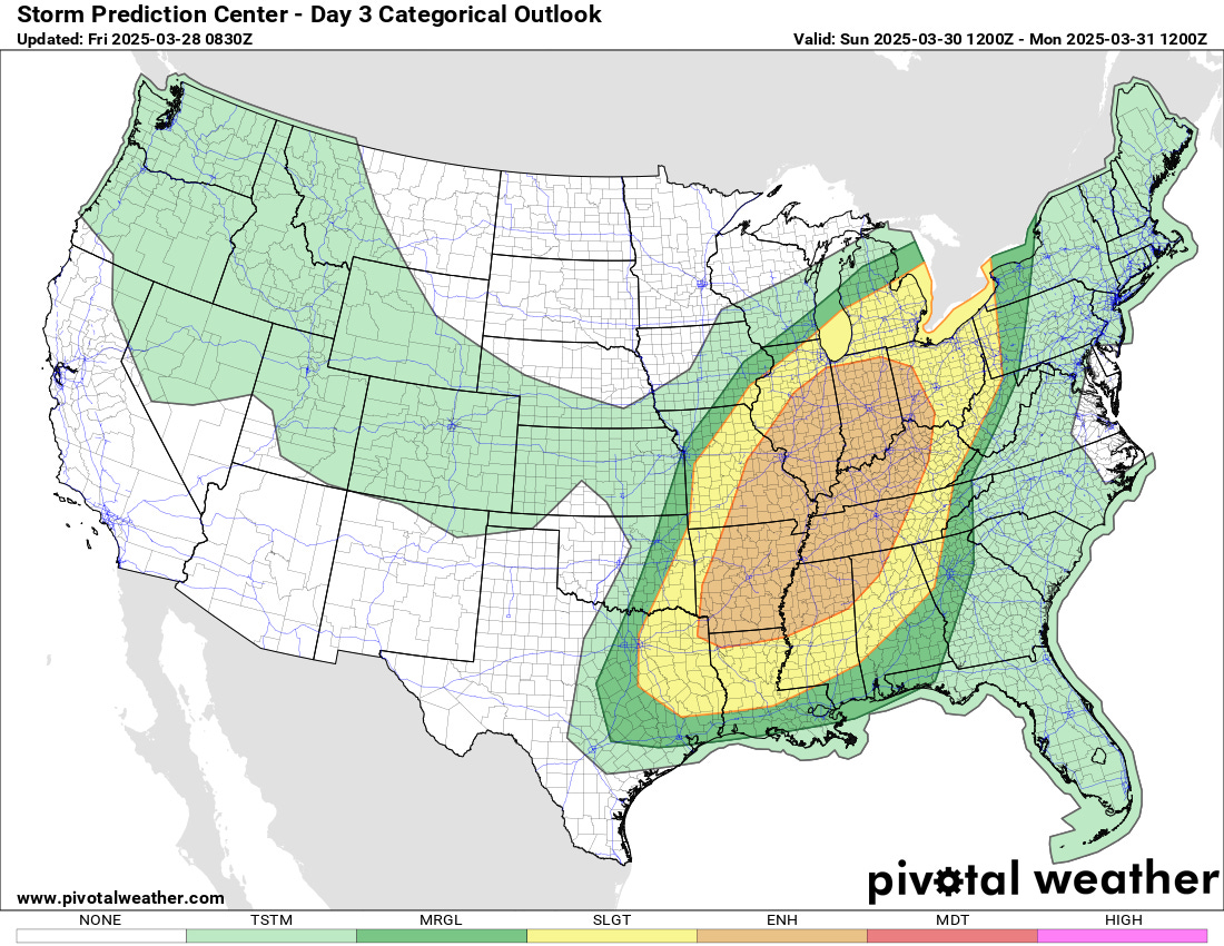
The severe weather risk for this weekend that we’ve been discussing for several days still looks on track. The risk of severe storms will begin increasing from northern Oklahoma to western Missouri later on Saturday as the responsible system begins to move east into the Plains. The threat will really ramp up and peak on Sunday, where SPC has outlooked a large area from the Arklatex and Arklamiss north to Indiana and western Ohio in an enhanced (level 3 of 5) risk of severe storms. As we have discussed over the last few days, this looks like a setup where a large area will be at risk for impactful severe weather, and some particularly intense severe storms with damaging straight line winds, very large hail and significant tornadoes could occur within this broader area. As we get closer to the event and start to get high resolution model forecasts, we should be able to better refine the risks from this event.
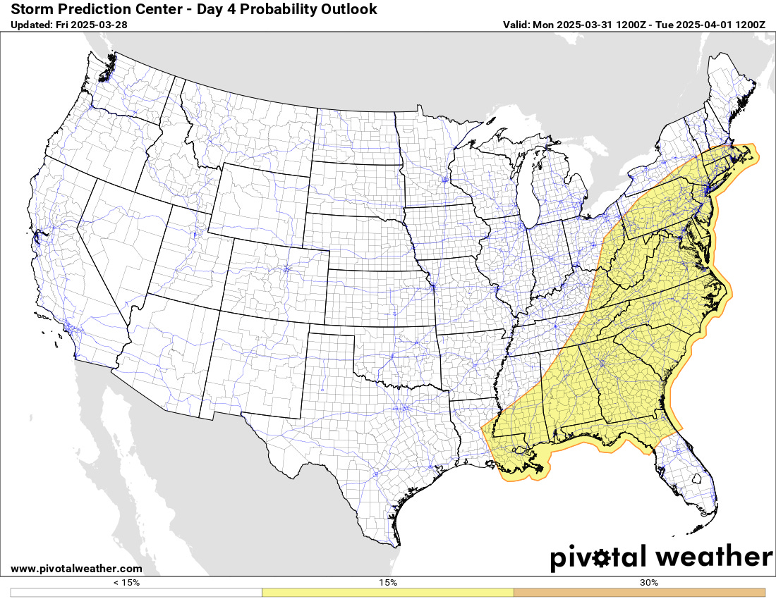
As the system continues east, the threat of severe weather will shift with it, and SPC has outlooked much of the East Coast region in a 15% probability area of severe weather on Monday.
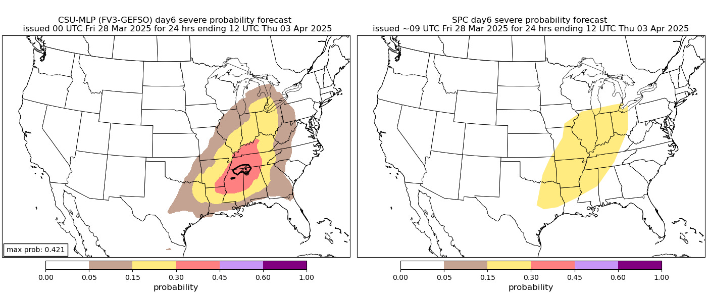
As discussed in my deep dive post yesterday afternoon, it still appears as though the weather pattern will be quite active for severe weather beyond this weekend’s system. The next day of interest looks to be next Wednesday, when a strong upper level disturbance should move across the Midwest. The Colorado State University machine learning system (CSU-MLP) is already highlighting a 30% probability area for severe along with a small hatched area for significant severe weather. I noted in my discussion yesterday that the CSU-MLP is based upon the NWS Global Ensemble Forecast System (GEFS), and for this particular setup next week there are still some rather important model differences as the European ensemble suggests the better threat of severe storms would be a bit more northwest of what the GEFS suggests. For now, as can be seen on the right hand image above, SPC is forecasting a large 15% probability area for severe weather. As of now, this system also looks to have the potential to produce a rather substantial severe weather episode, and we will continue to discuss the risk in coming newsletters.