


Record heat in parts of Europe and Asia
Summer thunderstorms around much of US heading toward Fourth of July
As we start a new month, meteorologists start to receive the data that summarizes the previous month. While it will be a bit longer before we get statistics from the entities that monitor the global statistics, some national statistics have started to come in, and I wanted to highlight a couple of rather eye popping things I saw yesterday.
Japan and South Korea both set records for their warmest months of June on record. Incredibly, Japan broke their monthly record by nearly a full degree C. While I realize that Japan is not a huge country in size, it is still rather impressive to break a national monthly average temperature by a full degree. As he notes, even hotter temperatures are expected in the region in the coming days; a few sites in Japan already set record monthly temperatures for July today.

The European heat wave peaked in extent today, with widespread 90s and low 100s Fahrenheit maximum temperatures from eastern France across much of central Europe, including 100F at Frankfurt and Cologne.


Coming back stateside, as expected yesterday was a busy thunderstorm day across the Mid-Atlantic region, as thunderstorms with very heavy rainfall rates moved through during the afternoon and evening. 1-3” of rain was pretty common across Virginia, Maryland, New Jersey and parts of eastern Pennsylvania. Much of this rain fell in a rather short period of time, which led to numerous reports of flash flooding. Areas around Baltimore, Philadelphia and Reading PA were particularly impacted by flash flooding with severely flooded roadways and water rescues reported.
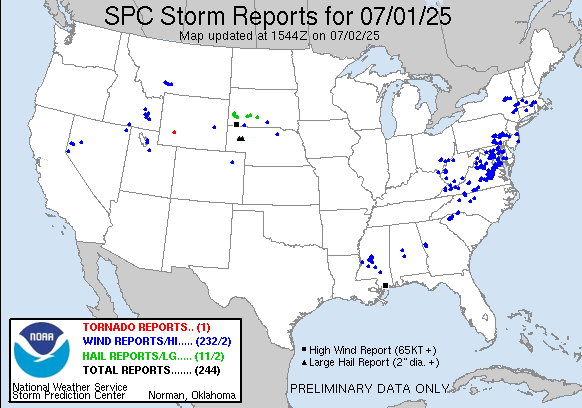
There were also a number of reports of damaging winds across the eastern US, as well as widely scattered severe storms across portions of the northern Plains and the Intermountain West.

Today will see scattered showers and thunderstorms across much of the eastern two-thirds of the country, with more organized complexes of storms with some localized flash flooding potential across the Southeast including Florida. In the West, monsoonal moisture will fuel scattered showers and thunderstorms as well, with flash flooding possible especially in southern Arizona and New Mexico. This will bring a bit of a break to the heat that has been in this region over the last few days; Phoenix set a record daily warm minimum temperature on Tuesday with a low of 93F.

Thursday will be a pretty similar day to today weather wise. A band of tropical moisture ahead of the sagging cold front over the Southeast will focus numerous showers and thunderstorms with heavy rain along it, including across Florida. An upper level disturbance moving across the Northeast and Great Lakes could focus some stronger storms in this area, with the possibility of a few severe storms with damaging downburst winds the primary threat.

By Independence Day, heat will return again to the upper Midwest, with widespread moderate to major heat risk expected.

Scattered summertime showers and thunderstorms are expected across much of the country. More widespread showers and thunderstorms with locally heavy rain will continue on the Fourth over Florida with the focused band of tropical moisture across that region.

Speaking of the tropical moisture plume off the Southeast coast, that continues to be an area of attention for possible tropical development by this weekend. The model trends have not changed too much in the last 24 hours, with the area east of Florida looking like the most likely area for any development to occur. It still seems like any system that forms would not be particularly strong and NHC is showing a medium (40%) chance for development. We will continue to watch.
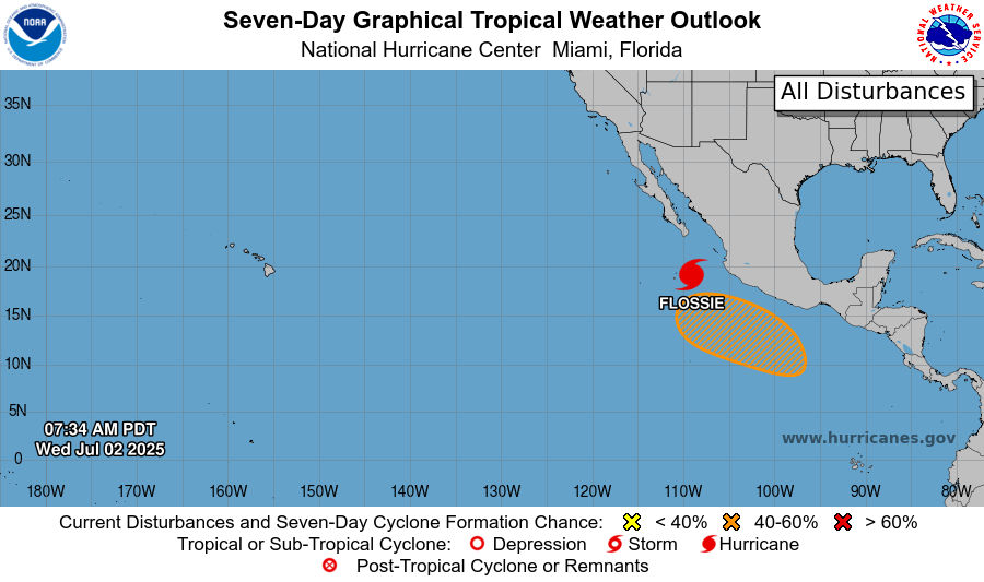
Meanwhile, in the eastern Pacific, Flossie did become a major hurricane overnight, but has already started to weaken. That will continue and the system will move off to the west as it dissipates, though some of the moisture from Flossie will continue to be pulled into the monsoonal moisture feeding shower and storm activity in the Southwest. Another system is likely to try to form behind Flossie, and NHC currently has a medium (50%) chance of formation this weekend into early next week.