
Observational and model trends continue to support potential for an all-time El Nino event heading into winter
Global sea surface temperatures are currently running at record warm levels
Some new forecast and observational data related to the strengthening El Nino event came out in the last few days that I want to focus on in this evening’s newsletter.
Data from the Climate Reanalyzer site at the University of Maine showed that global sea surface temperatures (between 60S and 60N latitude) reached an all-time record yesterday.
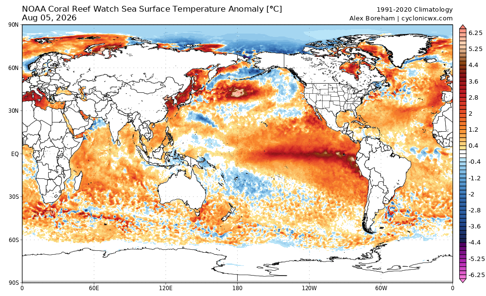
While the growing El Nino is playing a key role in this record warmth, the global SST anomaly map shows that most of the globe is witnessing above normal water temperatures, with particular areas of warmth in northwest Pacific (5+ degrees C above normal) and in the Mediterranean.
I will admit to being slow to jump on the “super-duper record El Nino” bandwagon when it was revving up early this year — mainly due to the spring predictability barrier which often results in significant errors in early forecasts for El Nino state for the following winter. However, we are well past that barrier now — and the ENSO (El Nino Southern Oscillation) forecasts have not only held firm, they have actually become more extreme. More importantly, the observational data shows that this El Nino is truly building at an unprecedented rate, with SST anomalies in the eastern and central equatorial Pacific at record levels for this time of year. I concur with noted climate scientist Zeke Hausfather — the rapidity with which the SSTs have warmed in the ENSO region is truly astonishing.
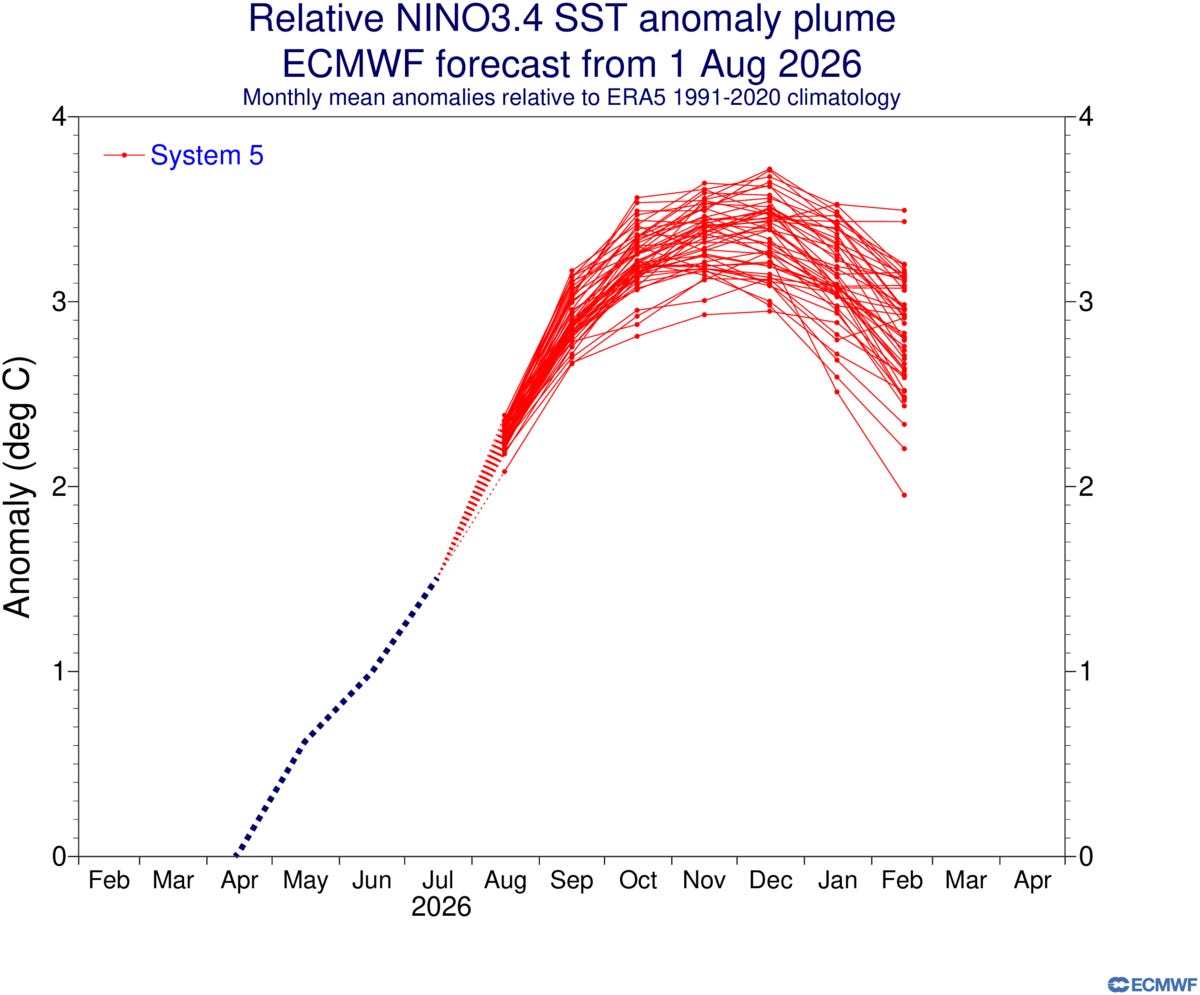
The August update of the European Centre for Medium-range Weather Forecasts (ECMWF) seasonal climate ensemble forecasts are showing the Relative Oceanic Nino Index (RONI) exceeding 3C through the winter. This would mean that this El Nino could have a peak RONI of a full degree above any of the previous top end El Nino events of the last 75 years such as 1982, 1997 and 2015.
University of California climate scientist Daniel Swain posted an excellent analysis of (ECMWF) seasonal ensemble forecast for the upcoming winter. As he noted, the model is showing extraordinary probabilities for this potentially record El Nino to result in extreme precipitation levels in the canonical locations for El Nino enhanced winter precipitation, namely California and the Southeast including Florida.
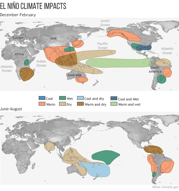
The combination of the observational data, ENSO forecasts and now precipitation forecasts from climate models makes it clear that officials in the public and private sector should be taking seriously the likelihood that this El Nino will produce major global weather and climate impacts as we head through the remainder of 2026 and into 2027 — and prepare accordingly.
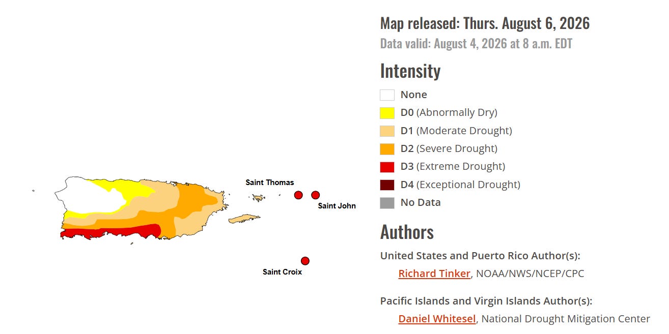
In the El Nino climate impacts graphic above, one of the anticipated impacts for this time of year is drought in the Caribbean, and this is in fact ongoing. Much of Puerto Rico and the Virgin Islands are dealing with significant drought, with southern and eastern Puerto Rico in severe to extreme drought. San Juan has only received 2.07” of rain since June 1 (as of yesterday), which is only about 20% of normal. Puerto Rico is implementing water rationing due to the serious ongoing drought.
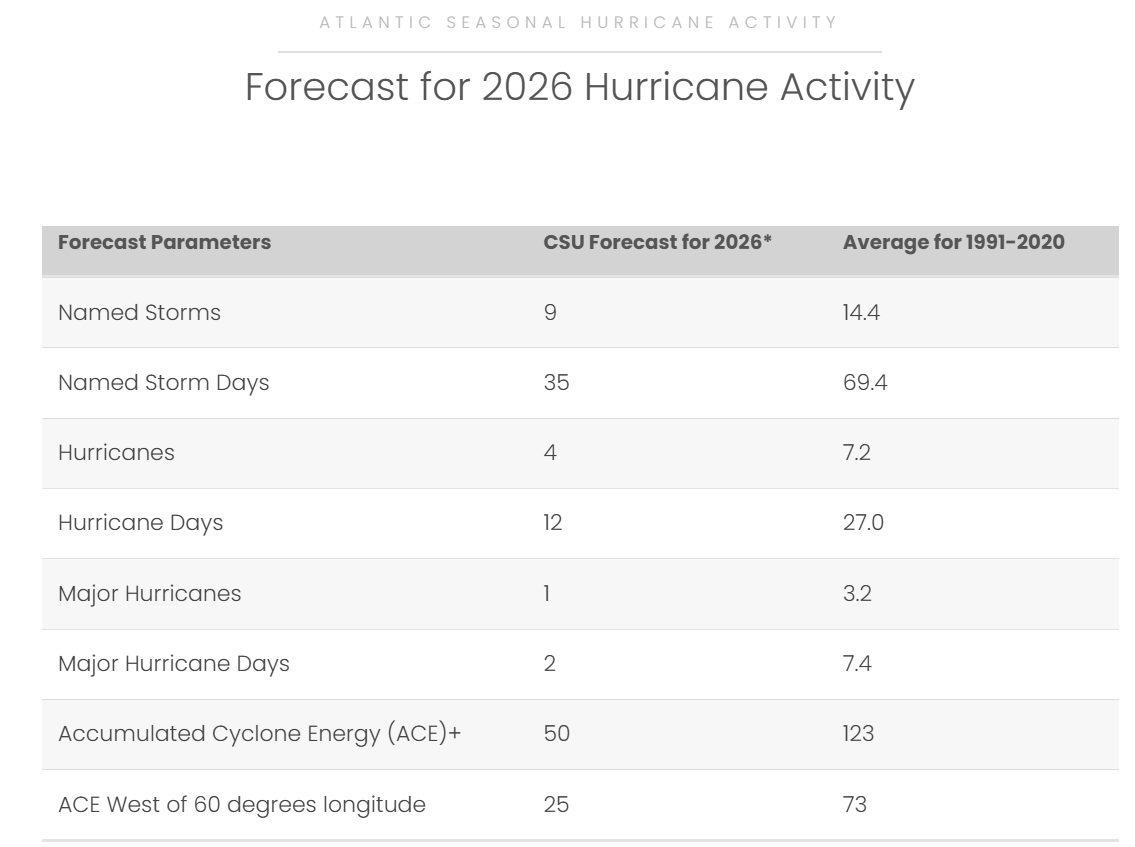
This trend toward drought in the Caribbean in El Nino years is related to the typically reduced strength of tropical waves and numbers of tropical cyclones. Earlier this week, the renowned seasonal hurricane forecast team at Colorado State University issued their August update to their 2026 forecast (above), and further reduced their anticipated tropical activity in the Atlantic this season from earlier forecasts. If this forecast pans out, it would mean a much below normal season and would be a sharp change from recent active seasons.
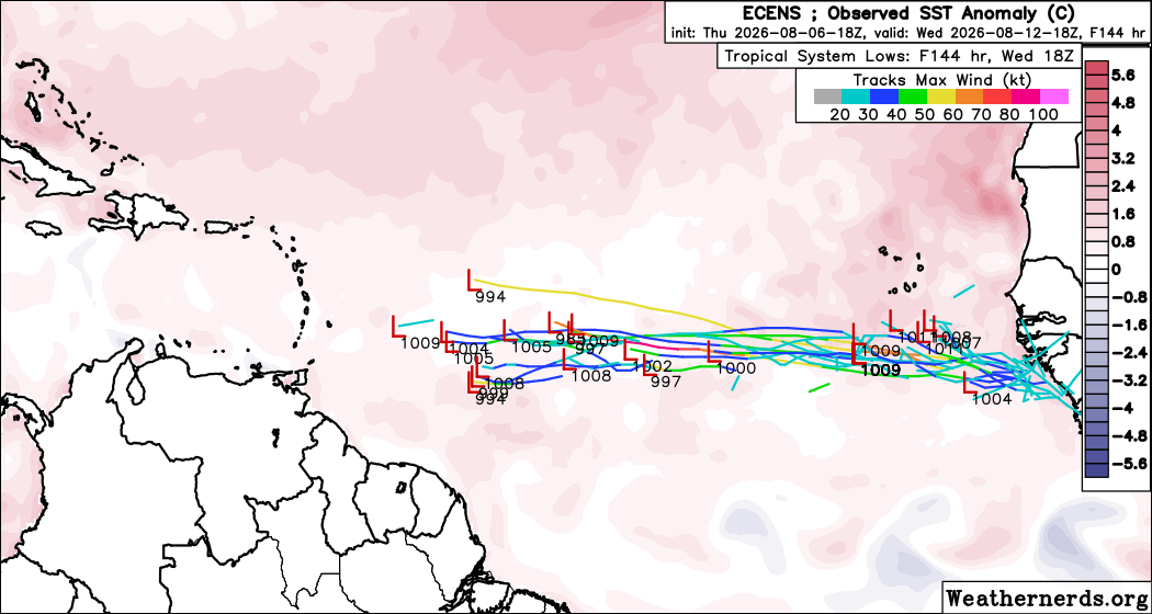
While the National Hurricane Center is not yet highlighting any areas of concern, the longer range ensemble models are actually showing the potential for a system or two to develop in the Main Development Region of the deep Atlantic tropics in about a week. Even in a below normal season, several strong tropical storms and hurricanes can be expected, and we are approaching the peak of the season from the latter part of August through early October when development is most likely. We will obviously be keeping an eye on trends in the coming days.
Programming note: I am posting semi-regularly again — but family commitments and travel after the passing of my mom will mean those posts will not be as frequent or consistently timed as they typically have been.
Balanced Weather is made possible by the generous support of paid subscribers, who as thanks get access to live Balanced Weather chats and videos as well as the ability to post comments and ask questions on posts. To become a paid subscriber or a free subscriber (also very much appreciated and you will automatically receive new posts in your email), please click below.