
Multiple waves of severe storms result in 1000 incidences of severe weather Tuesday and serious flooding
CNN: NWS suffers comms and IT failure that results in more than an hour of seriously delayed warnings during severe weather outbreak.
The last 48 hours have been incredibly busy with regard to severe weather and flash flooding across the central and eastern United States. CNN senior climate and weather reporter Andrew Freeman reported earlier today that in the middle of this outbreak of serious hazardous weather, the National Weather Service suffered a software and communications failure that prevented the agency from being able to disseminate severe weather warnings in a timely fashion other than via NOAA Weather Radio.
According to a person familiar with the matter, the root cause of the issue, which lasted from 6 p.m. ET to 7:14 p.m. ET (Tuesday), was a software upgrade being made to the main computer system that forecasters use to monitor weather conditions and issue watches and warnings, known as AWIPS. This software system is antiquated, and the NWS is working to update and replace it with a new cloud-based architecture by 2028, the person said. They were granted anonymity because they were not authorized to discuss the issue.
Forecasters at several local forecast offices in multiple states that were impacted by destructive storms — including Kentucky, Indiana and Ohio — were left scrambling to try to get their warnings out via media outlets, social media platforms and other means once meteorologists became aware that warnings they were sending out via AWIPS were not being received in a timely manner. In a post on X, the NWS forecast office in Jackson, Kentucky, wrote at 6:06 p.m. ET: “***This is urgent*** . We are having issues with our warnings getting out to everyone. If you are in Hazard, Jackson, Pikeville, and Whitesburg, PLEASE SEEK SHELTER NOW. This is a dangerous line of storms!”
In some cases, warnings were delayed as long as 20 minutes or more between the time of issuance and when they showed up on weather apps, in TV stations’ graphic systems, and via text and wireless alerts, among other means.
This is obviously a major failure in the National Weather Service’s most fundamental mission, namely to issue warnings for life-threatening weather hazards. As Andrew notes in his article and I have outlined in several previous posts, this IT and comms failure is symptomatic of a chronic deterioration of the NWS’ infrastructure. This decay has been worsened by the budget and staffing cuts of the last 18 months, but these issues are the result of chronic underfunding and neglect of organizational changes to the agency that have been needed for many years.
An NWS spokesperson acknowledged the outage to CNN, and said that the NWS “will continue to investigate the root cause of the delays to prevent the issue from reoccurring. As always, NWS advises everyone to have multiple ways of receiving critical, time-sensitive warnings.”
I have to admit that last sentence really rankles me. It is a statement that members of the weather and emergency management communities repeat endlessly to the public: have multiple ways to receive warnings so that if one fails, others will work. Saying that at the end of an NWS statement about an hour plus outage that affected all of the core dissemination pathways for NWS warnings except NOAA Weather Radio (which only about 1 in 4 or 1 in 5 people own) seems tone deaf and putting the onus on the warning receiver instead of the entity responsible for issuing the warning.
Perhaps instead of worrying about the public having multiple ways of receiving warnings, the NWS should be worried about having hardened, redundant IT and comms systems and backups that would minimize the likelihood of these sorts of outages? As noted in the CNN article, the NWS is in the progress of obtaining a new computing and communication system to replace its current “antiquated” AWIPS system. However, that system is still in the early stages of development and is not slated to begin deployment until 2028 — and given typical federal government processes, slippage of the timing for that new system certainly seems plausible. Hopefully the NWS is not only looking at the root cause of this event, but is also looking at backup methods to get warnings out during comms failures that will likely happen again before a new computing system is implemented agency wide.
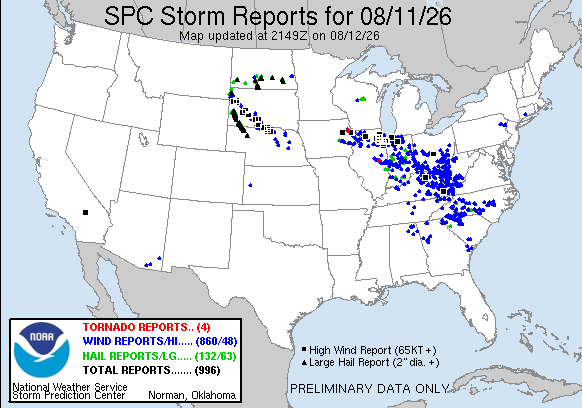
Let’s turn to the weather that was the concern during this NWS outage. As we have been discussing the last few days, the weather pattern has been very favorable for complexes of high-end severe storms to move across the region from the northern Plains to the the central Appalachians. Multiple complexes of storms developed in this area Tuesday, resulting in one of the busier severe weather days in recent memory with nearly 1000 reports of severe weather documented so far — including 4 dozen significant straight line wind gusts (75+ mph), 60 reports of very large hail 2” in diameter or larger, and several tornadoes.
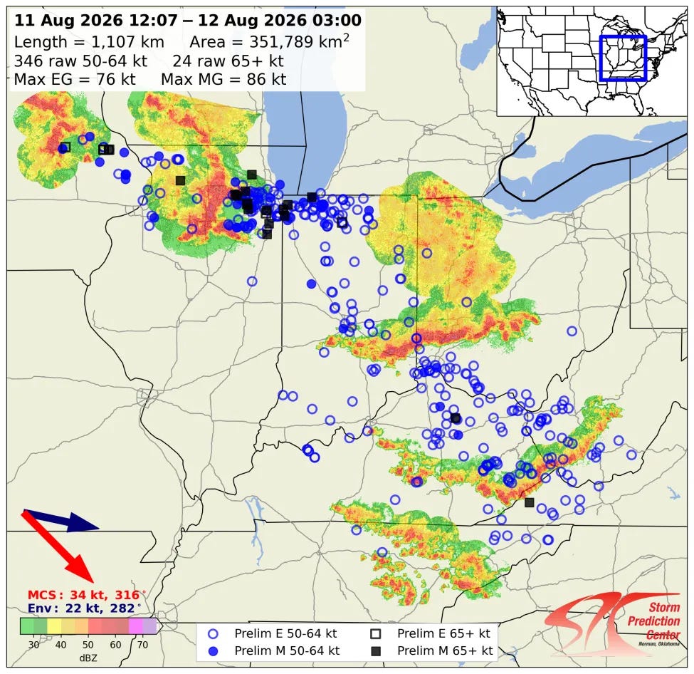
One of these storm complexes intensified over eastern Iowa early Tuesday and move east across northern Illinois before turning southeast to sweep across Indiana, southwest Ohio, eastern Kentucky and adjoining parts of West Virginia, Virginia and Tennessee.
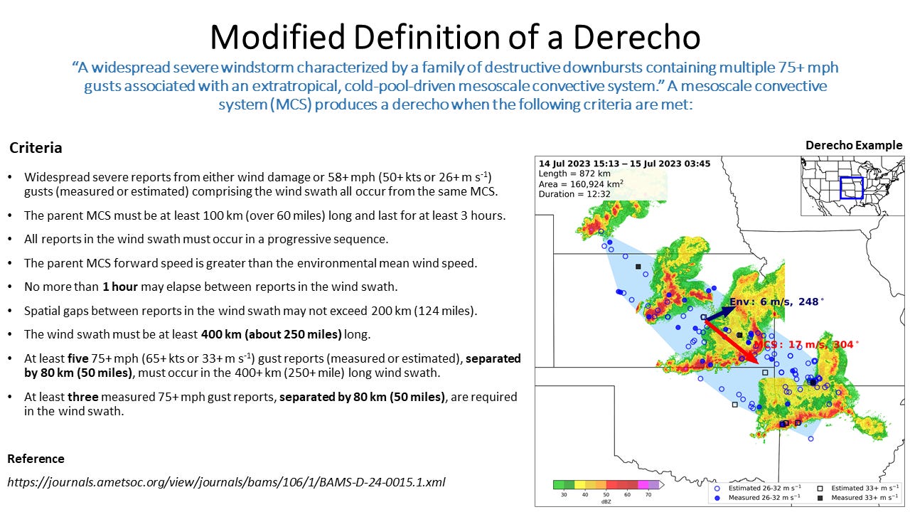
The NWS Storm Prediction Center reported today that these storms met the criteria to be classified as a derecho - a long-lived complex of severe storms that produces widespread damaging winds including multiple 75+ mph wind gusts. Damage along the path of this derecho was extensive, with hundreds of thousands of customers losing power and extensive damage to buildings, trees and homes. As of this afternoon, more than 500,000 customers remain without power in Indiana, Illinois and Ohio per PowerOutage.us.
The Chicago metro area of northeast Illinois and northwest Indiana was particularly hard hit, with multiple reports of winds in excess of 80 mph and at least four confirmed tornadoes — which brings the 2026 number of tornadoes in the Chicago area to 69, a record. 85% of the 200,000 electrical customers in Lake County, IN remain without power this evening, more than 24 hours after the storms hit.
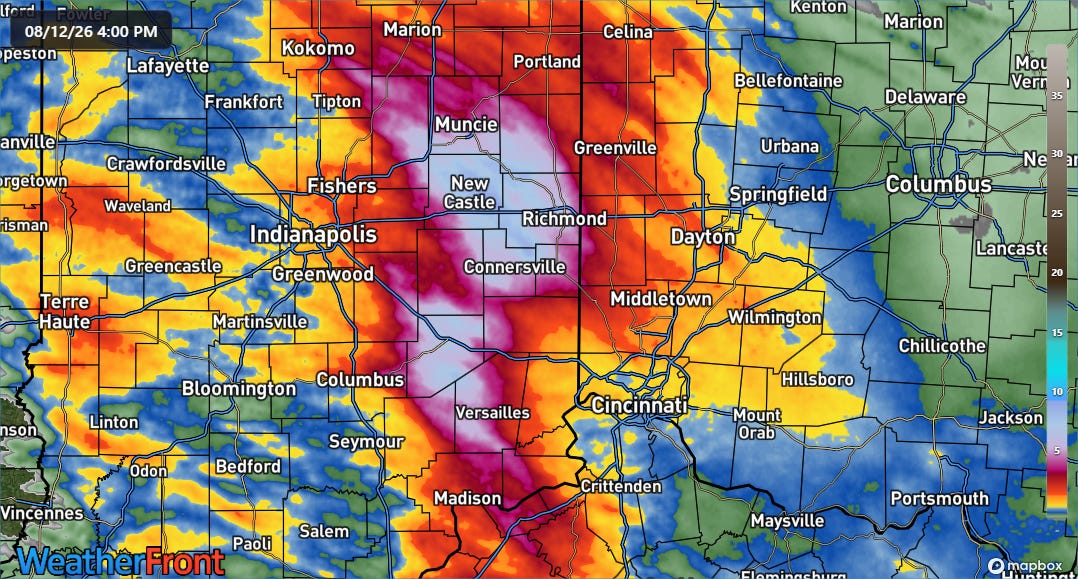
In last night’s newsletter I talked about the potential for significant flash flooding in parts of Indiana, and that was in fact the weather hazard that impacted eastern Indiana overnight into today. Rainfall estimates from the NSSL Multi-radar Multi-sensor (MRMS) system show widespread 24-hour rainfall amounts in excess of 5” with amounts as high as 10” in east-central Indiana around New Castle and Richmond. Numerous flash flood emergencies were issued by the National Weather Service in the region, and many flooded roads, buildings and evacuations were reported. Several streams and rivers in the region are forecast to reach major flood stage in the next day or so.
I will have more on the forecast for the next few days — including building heat for parts of the South and Southeast and tropical threats in both the Atlantic and Pacific — in tomorrow morning’s newsletter.
Balanced Weather is made possible by the generous support of paid subscribers, who as thanks get access to live Balanced Weather chats and videos as well as the ability to post comments and ask questions on posts. To become a paid subscriber or a free subscriber (also very much appreciated and you will automatically receive new posts in your email), please click below.
"Perhaps instead of worrying about the public having multiple ways of receiving warnings, the NWS should be worried about having hardened, redundant IT and comms systems and backups that would minimize the likelihood of these sorts of outages?" THANK YOU, THANK YOU for saying that, Alan. Stop blaming the victims.
As you know, the NWS has serious issues that seem to worsen by the month. There are people (I will not name names) who defend the agency no matter how bad the situation. Regarding the Baltimore Tornado mess: https://www.mikesmithenterprisesblog.com/2026/08/the-incorrect-tornado-warnings-near.html The NWS screwed up that situation, period. In a healthy environment, the NWS would list what they were going to do (training, etc.) to make sure that doesn't occur again. Instead, the usual suspects defend this performance regardless of how bad it was.
We have GOT to get a National Disaster Review Board that, in addition to investigating situations like these, takes over the verification of storm warnings and removes that conflict-of-interest. Otherwise, we don't know the true issues.