
Multiple tropical threats evolving in the Atlantic
Gabrielle expected to impact the Azores as a hurricane, while disturbances in the Atlantic need to be closely watched from Bermuda to the East Coast and Bahamas
The tropics remain very busy this morning, and we will start off with Hurricane Gabrielle. While Gabrielle has weakened a bit as it encounters cooler waters and increasing wind shear, it is still a formidable hurricane as it races east in the north Atlantic. While the eye is no longer clearly visible, it is still producing intense thunderstorms near the center and is relatively symmetric. The National Hurricane Center estimates it maximum sustained winds at 110 mph, at the top of category 2 of the Saffir-Simpson Hurricane Wind Scale.
While Gabrielle will continue to move across increasingly colder water, it will also be favorably interacting with an upper level trough of low pressure approaching from the northwest. This is expected to keep Gabrielle at hurricane intensity as it moves across the Azores in a couple of days, and significant wind impacts are anticipated there with a hurricane warning now in effect. While it should weaken more significantly after it passes the Azores and become fully post-tropical, it could bring some wind and rain to the Iberian Peninsula this weekend.
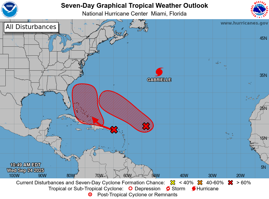
After Gabrielle, all attention will be focused on the two invest areas in the Atlantic, 93L (easternmost) and 94L (westernmost), both of which now have high probabilities of development into tropical cyclones over the next several days per NHC. It is important to emphasize that having two systems developing as close to each other as these systems will inject inherent uncertainties into the forecast over the coming days as very difficult to anticipate interactions between the systems can affect both the track and intensity forecasts.
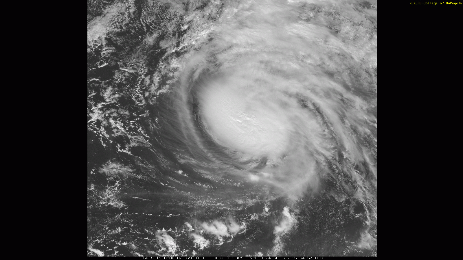
We will start off with the relatively “clearest” part of the forecast scenario, the short and medium term evolution of 93L. The system looks to be getting better organized in visible satellite imagery this morning, with what looks to be a relatively well defined low level circulation around 19.0N, 54.0W and increasing thunderstorm activity wrapping around the northeast side of the circulation.
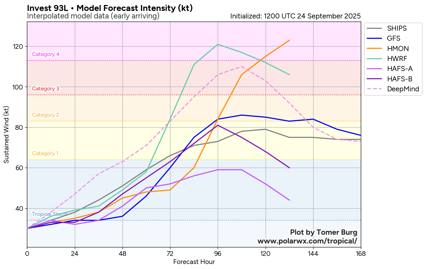
93L is still under west to southwest upper level wind shear, which is confining the thunderstorm activity to the east side of the system and will likely keep development slow for the next day or two. After that, though, it should start to come into a more favorable area for development, and intensification should become more rapid. Nearly all forecast guidance (hurricane/global model forecasts of max sustained winds shown above) show 93L becoming a formidable hurricane south of Bermuda this weekend, and it seems fairly likely it will become the Atlantic’s next major hurricane.
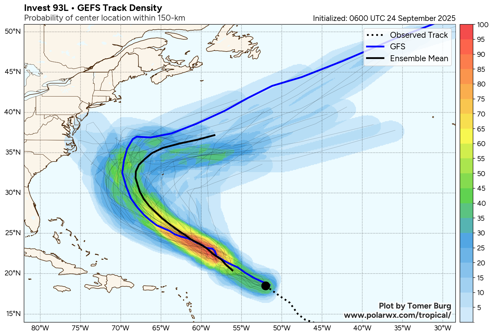
While the track forecast has plenty of uncertainty given the potential interaction with 94L and an increasingly complex overall atmospheric pattern, as of now it looks most likely that it will track northwest the next several days to a position south or southwest of Bermuda in about 5-7 days. Given the potential size and intensity of this system, Bermuda needs to be paying particularly close attention to 94L.
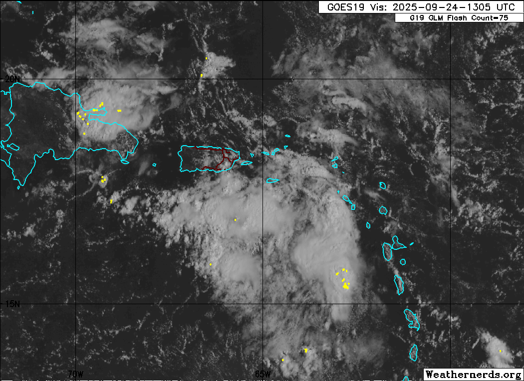
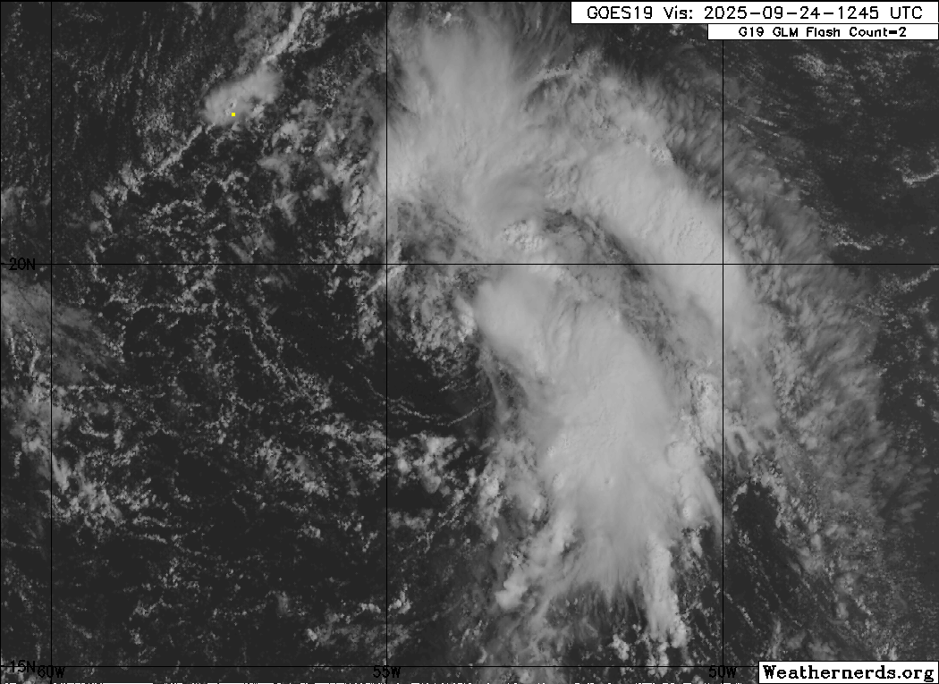
Looking at 94L, whatever circulation exists with it looks in morning satellite imagery to be somewhere just south or southeast of Puerto Rico. It is not as far down the organization road as 93L and will have some tough sledding for a couple of days for a few reasons. First, it is clearly dealing with wind shear and surrounding mid level dry air — you can see in the satellite loop the tops of thunderstorms being blown off to the east, a sign of strong upper level westerly wind shear. Secondly, it is going to be interacting with large, mountainous islands of the Greater Antilles as it moves west-northwest over the next few days, which will also keep development slow.
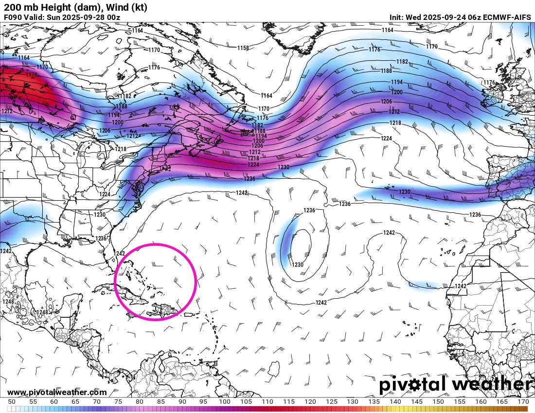
However, once it gets past Hispaniola and moves toward the Bahamas this weekend, as we have been discussing it should be getting into a much more favorable environment to the south/southeast of the East Coast upper level trough (purple area on the Saturday 200 millibar (40K ft AGL) weather map shown above).
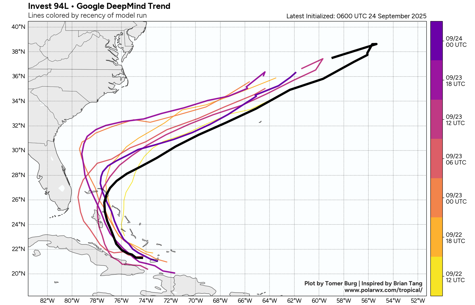
Needless to say, the forecast scenario with 94L is highly uncertain. The map above shows the average track of all of the members of each 6-hour run of Google DeepMind AI system over the last couple of days, and you can see how it has waffled around on where the system will develop and how it will track. Along with the normal uncertainty, 94L will also be in a very complex steering flow environment, with the upper level trough discussed above weakening and pulling away, but likely leaving behind a remnant upper low which could influence 94L. Additionally, there is the potential that interactions with 93L could affect the track and intensity of 94L depending on how large and intense each system gets. Bottom line: a tropical system of some intensity seems increasingly likely with 94L, but the longer term track and intensity is highly uncertain, and everyone from Cuba to Florida, the US East Coast, and Bermuda should be keeping an eye on it.
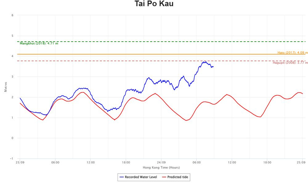
In the Pacific, Typhoon Ragasa made landfall in southern China overnight (US time) after causing significant impacts across the region. Hong Kong reported wind gusts over 130 mph and storm surge pushed water levels in Tolo Harbour (above) to 3.7 m above datum — similar to levels seen in Typhoon Hagupit in 2008 but luckily less than what were observed in Hato (2017) and Mangkhut (2018). Earlier heavy rainfall from Ragasa caused flash flooding in Taiwan with a burst lake killing at least 17 people.
A new tropical storm — Bualoi — looks to be strengthening as it approaches the Philippines. It is expected to pass across the northern and central Philippines as a strong tropical storm or minimal typhoon in 36 to 48 hours, and eventually threaten Vietnam as well.
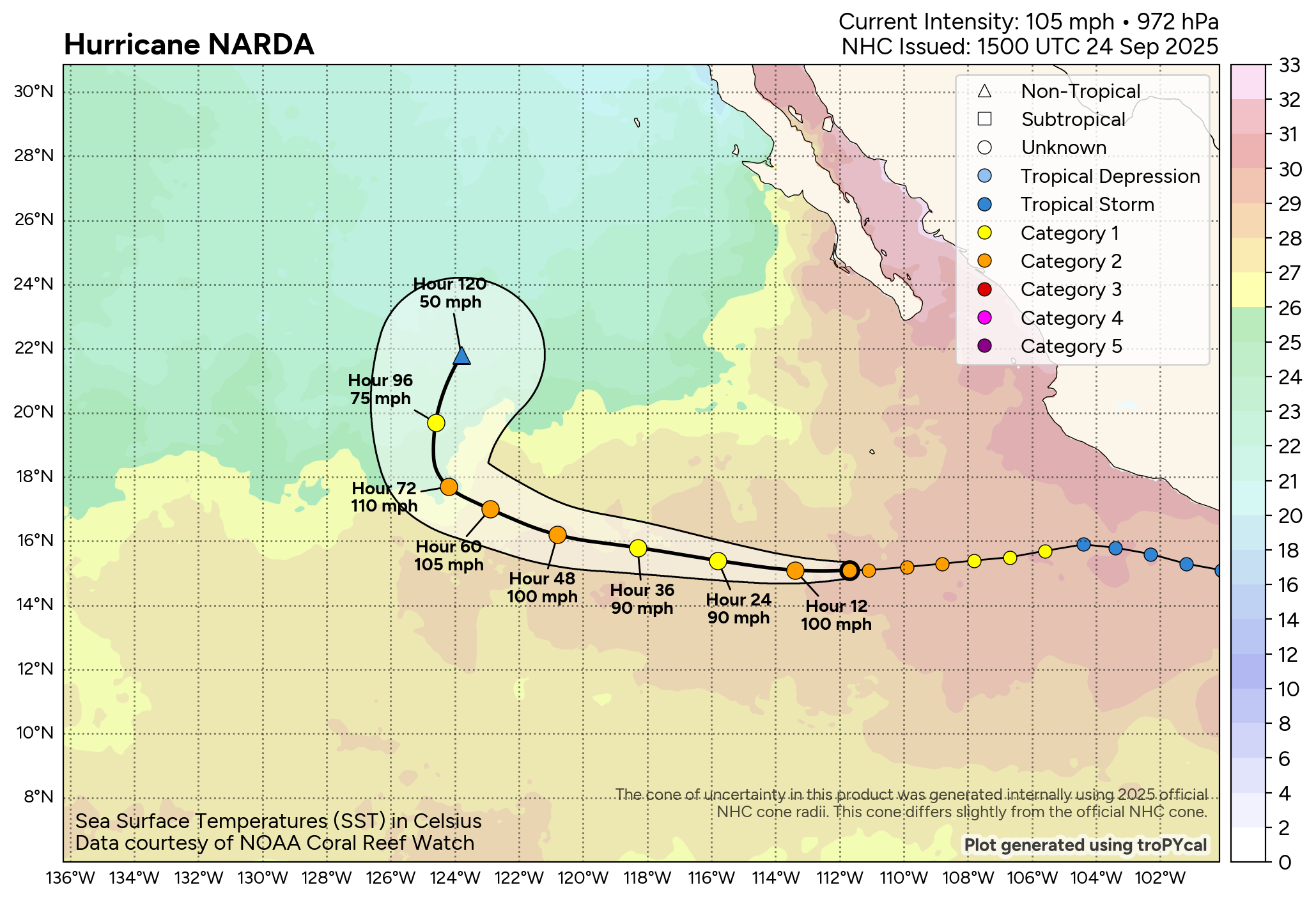
Finally, Hurricane Narda is in the eastern Pacific having made it to category 2 SSHWS intensity but now dealing with some upper level wind shear. It is expected to get another burst of intensification in a couple of days — but should recurve well southwest of Baja California.

Looking at US weather, strong thunderstorms will continue from the western Gulf Coast into the upper Ohio Valley and Northeast today as the slow moving central US storm system continues to plod east. Flash flooding will be the primary concern with these storms, although a few severe storms are possible as well. Severe storms yesterday blew the roof off of a hospital in eastern Oklahoma near Sallisaw, forcing the evacuation of patients and establishment of a mobile field hospital for emergency care.
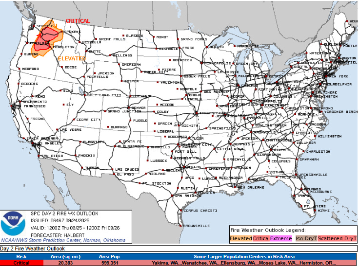
In the West, scattered thunderstorms are expected in central California including the Bay Area today. Thursday will see increasing wildfire risk for the Northwest, where SPC has outlooked critical fire danger for interior Washington and northern Oregon. Luckily, more manageable fire conditions over the last several days in this region have allowed firefighters to get a number of fires more under control, and the national wildfire preparedness level has been able to be lowered to a 2 on the 1-5 scale used by the National Interagency Fire Center.