
More than 200K customers without power in Massachusetts, with some outages likely to persist for days
Warm and dry weather making a return for much of the West this week
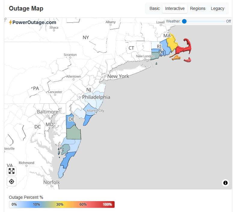
Good Monday afternoon — I will have more to discuss with regard to the Northeast blizzard in future posts, but today I want to give a quick overview of what is going on with weather across the rest of the nation. Before I dive into that, one update item from the blizzard is that nearly 300,000 customers remain without power from the storm, most of these in Massachusetts. State officials in an emergency management briefing this afternoon reported that electrical crews from as far away as Michigan and Canada are in Massachusetts working on restoration, but given the magnitude of damage and snowfall it will be days before some customers see power back.
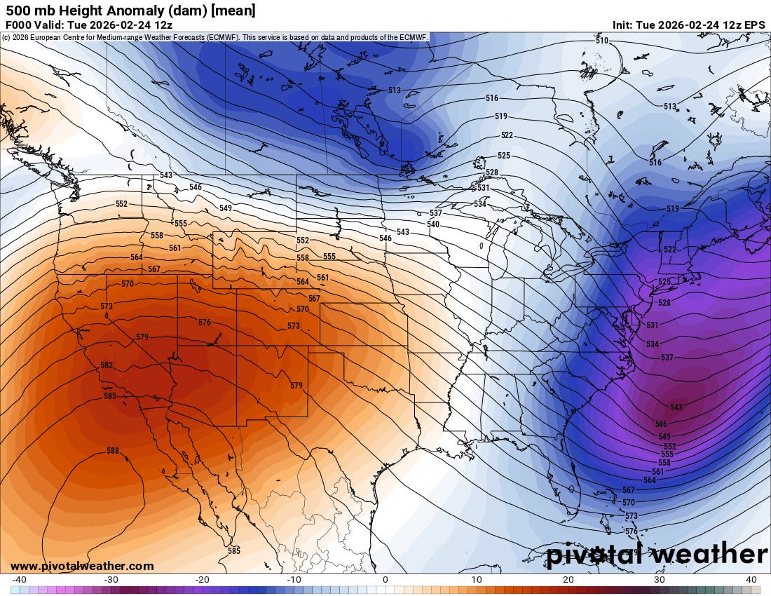
In a refrain that has been repeated much of this winter, the middle and upper level pattern across the United States currently is dominated by a strong trough of low pressure along the East Coast and an unusually strong area of high pressure over the West. The trough in the East was responsible for the blizzard and ensuing colder than normal weather — while much of the West is experiencing unusually warm weather for the end of February.
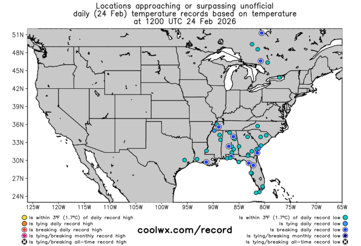
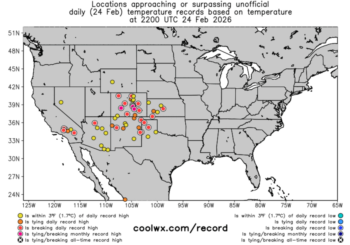
The plot of record temperatures (courtesy coolwx.com) being reached today show this dichotomy. This morning saw several record low temperatures set across the Southeast. Meanwhile, a number of locations in the Southwest and Plains are setting daily record high temperatures, with a few locations approaching monthly record highs. Amarillo, TX has reached at least 86F this afternoon, which broke its daily record by 5 degrees (February record is 89F).
The general weather pattern of strong upper level high pressure ridging in the West and a lingering trough in the East looks to persist for the next 7 to 10 days. The intensity of the trough in the East looks to gradually weaken which should allow some warmer air to gradually build into the Southeast, but periodic shots of Arctic air look likely to continue to penetrate the Great Lakes and Northeast.

An upper level system moving across the Northwest on the north side of the upper level high pressure is bringing rain and some high elevation heavy snow to that region today, while snow showers are occurring over the Northeast.
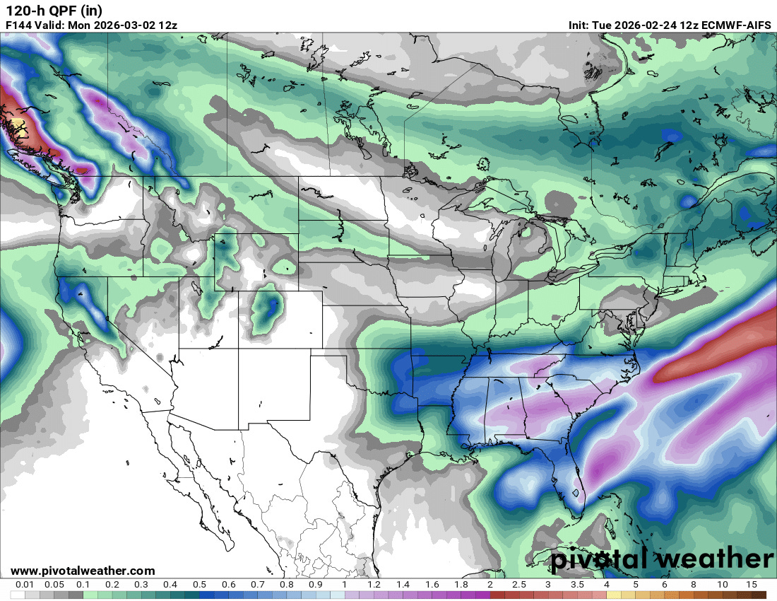
No major storm systems are expected the rest of this week, but a series of upper level disturbances dropping through the trough in the East will bring periodic showers and storms — and much needed rainfall — to the Southeast and Florida. Some periodic snow showers will continue in parts of New England. There are some model signals of a potentially more significant winter system for parts of the Midwest and Mid-Atlantic again early next week, but as with the last system, right now there is still a lot of spread and uncertainty in the models. More to come on this potential as the week goes on.
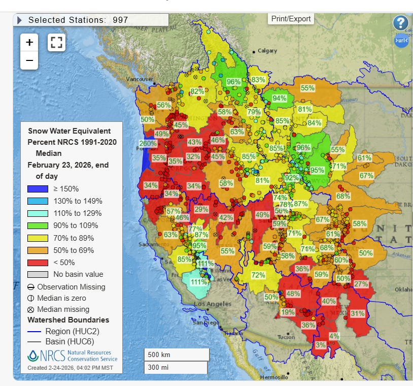
Meanwhile, the return of prolonged warm and dry weather to much of the West after a several day period of colder, wetter weather is concerning given that most of the region remains below to well below normal as far as snowpack. Only portions of the southern Sierra Nevada and the higher elevations of northwestern Oregon are above normal with regard to snowpack per the analysis from the USDA Natural Resources Conservation Service (NRCS), and many river basins in the West are running near or less than 50% of normal snow water equivalent (i.e, the amount of water that would be generated if all of the current snowpack was melted).
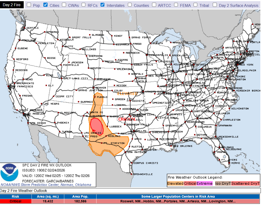
Farther east, widespread below normal precipitation over the last several months has also been an issue for much of the Plains and Southeast. As I mentioned above, the Southeast will receive at least some rainfall the next several days, but the Plains look to be primarily dry. Elevated to locally critical wildfire conditions are occurring across the Southern Plains this afternoon, and will be repeated again Wednesday in parts of the Plains to the east of the southern Rockies (shown above).
There are hints in the long range ensemble models that a pattern shift could evolve in about 10 days with an upper level trough of low pressure developing in the vicinity of the Rockies. If this materializes, it should mean a somewhat wetter pattern at least for portions of the Plains, although as of right now the ensemble models show below normal precipitation continuing for much of the Southwest.
Balanced Weather is made possible by the generous support of paid subscribers, who as thanks get access to live Balanced Weather chats and videos as well as the ability to post comments and ask questions on posts. To become a paid subscriber or a free subscriber (also very much appreciated and you will automatically receive new posts in your email), please click below.