


Moderate risk of severe storms in central US today as active pattern continues
Tropical Storm Erick likely to become a hurricane in eastern Pacific and make landfall in Mexico
Lots going on in the weather world today, so let’s get to it.

Yesterday was a very busy severe weather day from the central Plains into the upper Midwest with numerous reports of significant severe weather including tornadoes, very large hail and significant wind gusts.
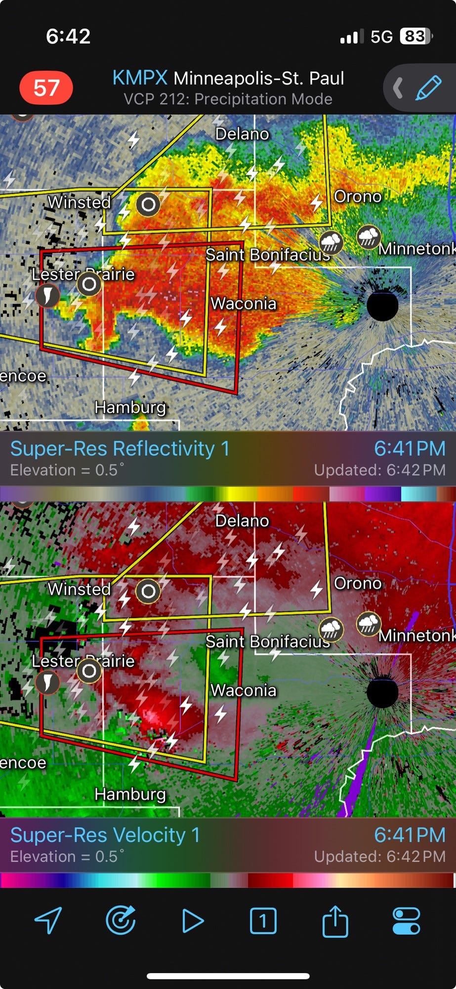
Some very classic looking supercells developed over parts of Minnesota with several tornadoes reported.
Additional supercells developed to the southwest over Nebraska with additional tornadoes - some of these were likely significant tornadoes, but appear to have been mainly over rural areas.
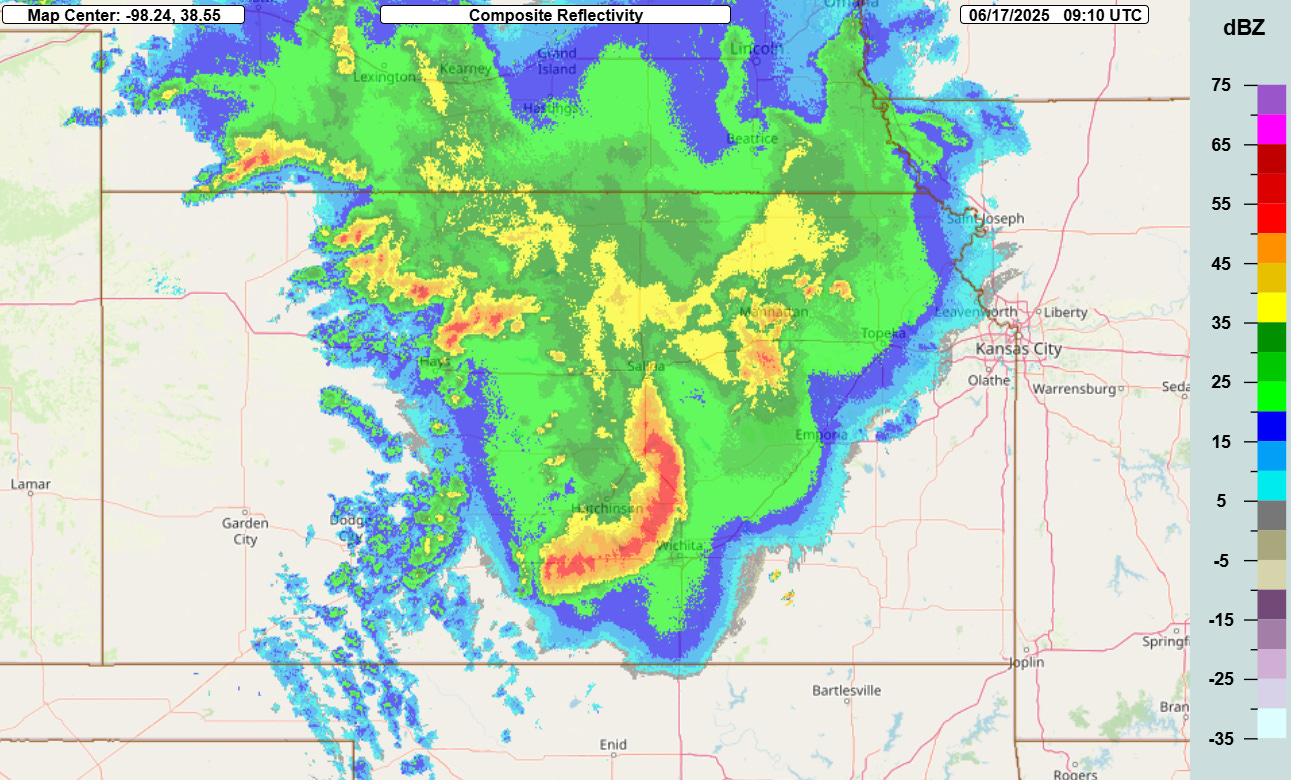
These supercells eventually evolved into a line of severe storms which moved south across Kansas, producing widespread, significant damaging winds with numerous measured wind gusts over 80 mph. Shortly after the radar image above (4:10 am CT), this bow echo moved through Wichita, producing a 101 mph wind gust at Wichita Eisenhower National Airport, which tied the highest wind gust ever recorded there.

The progress of the severe weather overnight will play a significant role in the severe weather today, as those storms have pushed a boundary south into Oklahoma. This boundary will likely start to shift back a bit north during the day, and will be the primary focus for rapid severe thunderstorm development with daytime heating. Scattered intense supercell storms are expected to develop with very large hail, damaging winds and tornadoes. Eventually, as transpired last night, these storms will likely evolve into a line of severe storms that should produce widespread, significant damaging winds. The NOAA Storm Prediction Center (SPC) has placed a moderate (level 4 of 5) risk of severe weather across southern Kansas and northern Oklahoma for this afternoon and tonight. The high resolution models differ on how far south and east the threat of significant severe winds will progress overnight, but folks in Arkansas and southern Missouri should stay up to date on forecasts this evening.
Another active severe weather day is anticipated Wednesday, as the disturbance responsible for today’s storms will initiate an intensifying area of surface low pressure that will move into the lower Great Lakes region. Depending on the eventual track and how much destabilization occurs near this low, an enhanced tornado risk could develop across parts of lower Michigan and northern Indiana. Additionally, a band of severe storms is expected along the trailing cold front which should present a risk of damaging winds.


In addition to the severe weather risk, flash flooding will be a significant concern, especially today. Both in the central Plains and the East, extreme moisture levels are in place and ground conditions are very wet. As additional thunderstorms develop this afternoon and evening, some areas of very impactful flash flooding are possible. The Weather Prediction Center has placed moderate (level 3 of 4) risks of excessive rainfall and flash flooding in both areas today.
Active severe weather is expected through the end of the week and into early next week. On Thursday, the low pressure system and cold front will push into the Eastern Seaboard region with an enhanced risk for severe storms with damaging winds and possibly a few tornadoes. Going into the weekend, a strong area of upper level high pressure will begin to take shape over the eastern United States in the wake of that frontal system. On the north and northwest side of that system, a series of upper level weather disturbances should bring an active period of severe weather to the northern Plains, upper Midwest and Great Lakes.
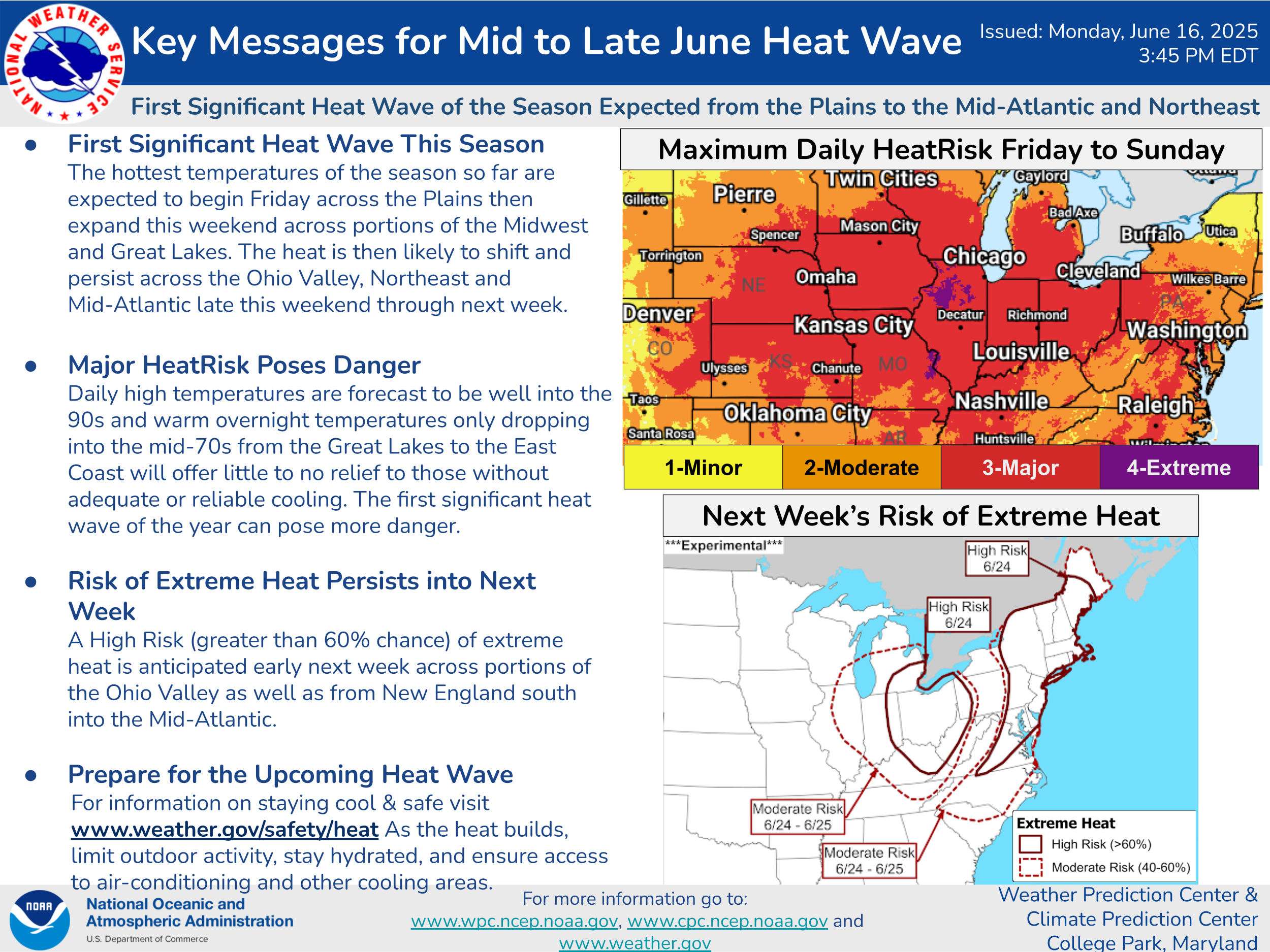
The upper level high pressure system over the East looks as if it will be unusually large and intense, and will likely bring a prolonged heat wave to the region during the weekend and into at least early next week.
![[Key Messages]](https://substackcdn.com/image/fetch/f_auto,q_auto:good,fl_progressive:steep/https%3A%2F%2Fsubstack-post-media.s3.amazonaws.com%2Fpublic%2Fimages%2F2b2d1ed3-2822-4df2-aebc-b34d5b8951a6_897x736.png "[Key Messages]")
Finally, in the tropics, Tropical Storm Erick has formed in the eastern Pacific to the west of El Salvador. Conditions look very favorable for strengthening, and the National Hurricane Center forecast expected Erick to rapidly intensify and become a strong category 2 hurricane before its forecast landfall in southern Mexico on Thursday. NHC notes in their discussions that given the nearly ideal conditions for strengthening forecast, Erick could be even stronger and potentially become a major hurricane. The exact landfall of Erick will be difficult to pinpoint as its path is forecast to be somewhat parallel to the Mexican coast, meaning that small deviations in the track could have large impacts on the landfall point. NHC has scheduled two reconnaissance flights into Erick on Wednesday to gather data on the structure and track of Erick to help with the forecast and warnings for the system.
Given all of the busy weather over the next few days, I am planning to initiate some live chat and video briefings, including live coverage of the reconnaissance flights into Erick. As a reminder, live chat and video are Balanced Weather paid subscriber benefits - you can find out more information at the link below.