Much of today’s newsletter is again going to be dedicated to the flash flooding catastrophe in the central Texas Hill Country. As of 10:30 am this morning, CNN is reporting that the death toll in Kerr County, where the most heavily impacted area along the Guadalupe River is located, has risen to 59, including 21 children. At least 12 people remain missing from the Camp Mystic camp amid a larger unknown number of missing.

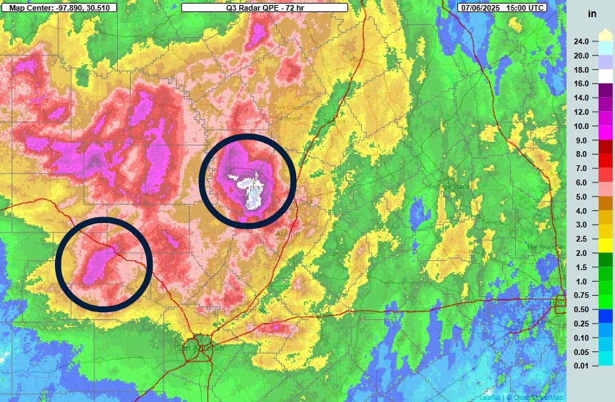
Several deaths have also been reported in Travis and Burnet counties near Austin from the flash flooding that occurred on Saturday morning from a separate complex of storms that produced even heavier rain the event in Kerr county on the 4th.
I put together an initial summary of my thoughts and perspectives on this event yesterday, but I have seen a tremendous amount of misinformation and misguided attempts to point fingers in the 24 hours since I wrote that post. Given that, I feel like it is important to share additional perspectives from someone who has as much experience in the meteorology and emergency management fields as I have. As part of that I think I need to point out where I see some potential failures to try to explain why a lot of what I see is misinformation and, in some cases, downright gaslighting. So even though I said in my post yesterday that I was going to avoid the blame game, I do feel like I will have to touch on where I see some potential failures in order to provide context to some of the misinformation out there.
I want to start all this by saying that I am absolutely heartbroken by this tragedy, and I am downright appalled by the amount of blatant misinformation I am seeing, not only from random accounts on social media but also from some established media outlets. It is also clear that many people are allowing their desire to score political points to color their insights and opinions on this tragedy. I am pleading with you as followers of Balanced Weather to read and share articles like mine and from other expert sources such as Marshall Shepherd and The Eyewall. I will also stress that what I am sharing here is my own personal perspective based on my experience, and based on what I know as of today. If I make mistakes - and I probably will - I will commit to being transparent about them and correcting things as soon as possible.
BULLETIN - EAS ACTIVATION REQUESTED
Flash Flood Warning
National Weather Service Austin/San Antonio TX
114 AM CDT Fri Jul 4 2025

The National Weather Service in Austin/San Antonio has issued a

* Flash Flood Warning for...
  Northwestern Bandera County in south central Texas...
  Central Kerr County in south central Texas...

* Until 415 AM CDT.

* At 114 AM CDT, Doppler radar indicated thunderstorms producing
  heavy rain across the warned area. Between 1 and 2 inches of rain
  have fallen. The expected rainfall rate is 2 to 3 inches in 1
  hour. Additional rainfall amounts of 1 to 3 inches are possible in
  the warned area. Flash flooding is ongoing or expected to begin
  shortly.

  HAZARD...Life threatening flash flooding. Thunderstorms
           producing flash flooding.

  SOURCE...Radar.

  IMPACT...Life threatening flash flooding of creeks and streams,
           urban areas, highways, streets and underpasses.

* Some locations that will experience flash flooding include...
  Kerrville, Ingram, Hunt, Waltonia, Kerr Wildlife Management Area
  and Lost Maples State Natural Area.

PRECAUTIONARY/PREPAREDNESS ACTIONS...

Turn around, don't drown when encountering flooded roads. Most flood
deaths occur in vehicles.

Be especially cautious at night when it is harder to recognize the
dangers of flooding.

In hilly terrain there are hundreds of low water crossings which are
potentially dangerous in heavy rain. Do not attempt to cross flooded
roads. Find an alternate route.

&&

LAT...LON 3013 9949 3013 9918 2990 9919 2990 9926
      2981 9931 2982 9960 3001 9959

FLASH FLOOD...RADAR INDICATED
FLASH FLOOD DAMAGE THREAT...CONSIDERABLE
EXPECTED RAINFALL RATE...2-3 INCHES IN 1 HOUR
This is the flash flood warning that was issued at 1:14 am CT by the NWS office in Austin/San Antonio for the area along the Guadalupe. As I noted in my piece yesterday, the warning was issued rather soon after thunderstorms developed and before any of the river gages in the area showed any sign of beginning to increase. Perhaps the most important thing about this warning is the use of the term “life threatening flash flooding” and at the bottom where it says “Flash Flood Damage Threat…Considerable.” That is the language that FEMA’s Wireless Emergency Alert system needs to see (or the even higher level of “catastrophic”) to activate the system and activate cell phone alerts in the area.
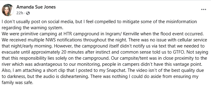
Obviously, the area where the flash flooding occurred is remote and I was unsure about cell coverage. A person who says she camps frequently in this area told me on BlueSky that while cell coverage is not great, it’s generally adequate and WEA alerts should have been received.
This is a Facebook post my wife shared with me that also provides evidence that WEA notifications were being received by people in the area. To be frank, this issuance of a flash flood warning with this impact tag to trigger WEA notification is the main tool that the NWS has to alert the public of life threatening flash flooding. It was issued early in this event, before significant impacts would have started. It was updated frequently, and shortly after 4 am it was upgraded to a catastrophic flash flood emergency. As this Weather Channel article notes, a flash flood emergency means:
A local or state emergency manager has confirmed rapidly rising water is placing, or will place, people in a life-threatening situation.
Water is expected, or has already rapidly risen, to levels where people in typically safe locations during other flash flood events will be in danger. These include cases where water could encroach several feet above floor level in a home, requiring rescue and putting the entire home at risk.
A number of swift-water rescue teams have been deployed to a flash flood of unusual magnitude.
River and stream gauges indicate water has risen to at least major or rarely seen flood levels.
There have obviously been a lot of questions about whether recent budget cuts and staff losses at the NWS impacted services for this event. In this Politico article, NWS forecaster Jason Runyen who was working the event stated that the local office had 5 people on staff during the flash flood event. Each NWS office is a bit unique with different workloads as far as providing emergency management and other partner decision support, so I cannot say for sure that this is an adequate number to do all of the warning support they typically do. On the face of it, though, it seems reasonable (2 people is the number that would usually be on staff on a “normal” night), and clearly the well done warnings seem to support that staffing was sufficient.
Having said that, that does not mean that there may not have been more subtle impacts from the recent NWS cuts. For example, this New York Times article notes that the Warning Coordination Meteorologist (WCM) and Science and Operations Officer (SOO) positions were both vacant in the Austin/San Antonio office. I happen to know both of the people who were in these positions prior, and they were both respected meteorologists with multiple decades of experience. The WCM is crucial as the position that oversees the decision support and warning programs with the local emergency management and broadcast meteorologist communities, and the SOO is the position that oversees the forecast and warning operations and ensures the staff has adequate training. Obviously, having both of these positions vacant for a prolonged time is not optimal, and certainly could have had negative impacts at some level. However, just looking at the actual warning services that NWS provided during the event, they were solid and provided the level of warning and alerts that the public should expect to receive for an event such as this.
A lot of the focus from local and state officials seems to be on the fact that the NWS forecast leading up to the event did not forecast as much rain as happened. An example from an NPR article:
"But listen, everybody got the forecast from the National Weather Service….It did not predict the amount of rain that we saw," said Texas Emergency Management Chief Nim Kidd on Friday.
Obviously, the rainfall forecast was somewhat underdone, and this is an area where research is being done to try to improve our ability to better predict these localized extreme maxima of rainfall that can cause devastating impacts.
I am going to make the case that in this situation this issue is mostly a red herring, and focusing on the shortfall of the rainfall forecast is distracting from other more important issues about warning reception and response. The fact of the matter is that the meteorological community recognized that this was a setup favorable for very heavy rainfall and flash flooding. A flood watch was issued based on this early Thursday afternoon, and NWS was highlighting increasing flash flood risk even before the issuance of the watch. On Wednesday - a full 36 hours before the tragic flash flood - based on the weather information they received from the NWS and their own staff meteorologists, the Texas Division of Emergency management activated state emergency response resources based on "increased threats of flooding in parts of West and Central Texas.” Per NPR, “swift water rescue teams, along with other types of rescue equipment, were moved to the area because some modeling predicted high levels of rainfall.”
Clearly, state emergency management was aware that there was a heightened flash flood risk in this region and took actions accordingly. Of course nobody anticipated the catastrophic level of flooding that occurred along the south fork of the Guadalupe because as I outlined in my post yesterday, it occurred because of a cascade of meteorological, hydrological and societal factors that resulted in a worst case scenario. As you can see in the above rainfall map, the rainfall that caused this event was a relatively isolated swath of particularly heavy rainfall of 7-10” in that particularly vulnerable river valley.
Of course, there are definitely ways that the meteorological and emergency management communities need to work together better to leverage probabilistic information and better communicate the risks of these low probability/high impact events at the forecast level. However, the reality of the state of meteorological science is that these types of small scale intense convective rainfall events can develop with much poorer forecasts and outlooks leading up to it than this one had. The fact of the matter is in areas particularly vulnerable to flash floods like this region is, you have to have some level of preparedness all the time during thunderstorm season and be ready to act whenever a warning is issued. The messaging from the NWS and the flood watch had clearly made the emergency management community aware of an even greater, heightened awareness based on their actions, and this awareness should have been maximized given it was a holiday weekend with lots of people out in this popular area for camping and outdoor activities.
Turning to local officials, this comment from Kerr County Judge Rob Kelly is telling in my opinion:
“This is the most dangerous river valley in the United States, and we deal with floods on a regular basis – when it rains, we get water,” Kelly said to reporters Friday. “We had no reason to believe this was going to be anything like what has happened here, none whatsoever.”
I am sorry, you do not get to have it both ways: you cannot say “this is the most dangerous river valley in the United States” and then act like what happened was a total shock. This exact river valley has had similar catastrophic floods in the past, including the July 1987 flash flood that killed 10 teenage campers and resulted in 33 having to be airlifted from trees and flood waters. Kelly also said:
The county considered a flood warning system along the river that would have functioned like a tornado warning siren about six or seven years ago, before he was elected, but that the idea never got off the ground because of the expense. “We’ve looked into it before … The public reeled at the cost,” Kelly said.
Whether or not a system like this was needed or cost-effective is obviously a much deeper debate, but clearly if this was considered, there was awareness with community leaders that a flash flood of this magnitude was possible. The fact that it wasn’t clearly forecast hours or days ahead of time is irrelevant because it’s never going to be forecast hours or days ahead of time with the current state of the science. As my colleague Matt Lanza pointed out in his post yesterday, in hindsight the catastrophic flooding from Harvey seems like it was obvious, but even the night that event was unfolding it was unclear whether or not the heaviest rainfall would actually fall over metro Houston or in more rural areas. The heavier than expected rain that fell in Travis and Burnet counties Saturday morning on the map above could have fallen 15 miles farther east and been a multi-billion dollar event with many more casualties. That is the nature of dealing with thunderstorm related hazards, be they flash floods, tornadoes, large hail, etc. - a shift of a few miles can change the impacts tremendously, and we do not have the forecast skill to anticipate the locations of those events down to the necessary scale to project impacts, even an hour or two ahead of time.
That brings me to my final point in all this. In a press conference about the flash flood yesterday, Department of Homeland Security Secretary Kristi Noem was asked (incorrectly) about the lack of NWS warning until after 7 am. Part of her response was:
“We know that everyone wants more warning time, and that’s why we’re working to upgrade the technology that’s been neglected for far too long to make sure families have as much advance notice as possible,” Noem said during a press conference with state and federal leaders.
I am going to be direct: this statement is gaslighting. As I have documented extensively, the Trump Administration is actively working to eliminate the Office of Oceanic Research and all of the NOAA weather laboratories and affiliated university cooperative institutes working on improving NOAA’s warning and forecast capabilities. Promising NOAA research-to-operations efforts that would actually help with some of the challenges I discuss above, including Forecasting a Continuum of Environmental Threats, Warn-on-Forecast, and FLASH would be terminated under the current FY26 presidential budget. Not only is the administration not doing what Secretary Noem claims, they are clearly doing the opposite, not only with NOAA but other federal science agencies, destroying the research apparatus that would actually upgrade technology and provide more advance notice of horrific events such as this flash flood.
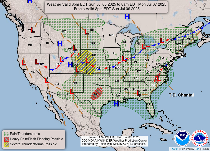
Finally, will finish with today’s weather map and a quick overview of what’s going on weather wise. Chantal reached a 60 mph tropical storm before making landfall near Myrtle Beach early this morning. It has weakened to a tropical depression but will continue to produce heavy rain as it moves northeast and eventually back offshore. Locally heavy rains continue in central Texas where a slight risk of additional flash flooding is in place, but overall the threat continues to slowly wane. A slight risk of severe storms is in place for the central High Plains where scattered severe storms with large hail and damaging winds are possible.


Bravo- Alan!
I'm glad you have documented that the NWS Warnings were timely and of sufficient gravity. EWX had 5 forecasters working the event all doing their jobs with sober intent to prevent loss of life. It was unfortunate that this event (like the July 1987 event) proved so intense, this time taking many more lives. The perfect storm- with holiday assembled humanity at a most inopportune time of night.
But thanks for pointing out that through all the chaos of political upheaval, the NWS was still doing their job expertly. These are good people who should not shoulder blame. I suppose some today are likely second guessing what additional things they might have done to warn the public.