


Heat wave rolls on in the east and flash flood concerns for New Mexico
And the first (brief, weak) Atlantic tropical storm forms

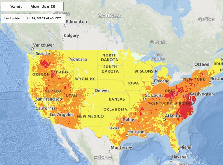
The heat across the eastern half of the country definitely was the major weather story of the last 24 hours, and will continue to be so today. The map above shows the observed heat index at 3 pm CT; this map only plots the main NWS/FAA/NOAA sites as temperature and particularly dewpoint observations tend to not be as well calibrated at non-federal sites and can show erroneously high values. Widespread values greater than 100 in the Midwest are apparent, and then also in the Northeast and Mid-Atlantic regions.
I particularly want to highlight that the highest values on this map are actually in the far northeast corner of it: 108F at Ottawa and Albany, and 110F at Burlington, VT, which was achieved by having an ambient temperature of 97F and a dewpoint of 75F. As a meteorologist, it is pretty insane for me to see these kind of values that far north (though it is growing more frequent). Burlington broke their daily record high temperature yesterday by 3 degrees with a high of 99F, and nearby Plattsburgh, NY tied their all-time record high with 101F. The record at Plattsburgh is indicative of part of what is impressive about this heat wave, namely that it is happening so early in the year. Heat of this magnitude is typically a later in the summer phenomenon. Plattsburgh has had 100+F days two other times, but both times in August. With 101F yesterday, Plattsburgh broke their monthly record for June by 4 degrees.
Obviously, these locations were not alone in setting records yesterday as dozens of record warm temperatures - both maximums and minimums - were set from the Midwest to the East Coast. In the New York City metro area, Central Park, Islip, Newark and Bridgeport all set daily warm records for both high and low temperatures. In the Philadelphia region, Philadelphia, Atlantic City and Wilmington DE also reached both record highs and record warm lows. Alpena MI set their all time record warmest minimum temperature by 2 degrees, only getting down to 79F; they also set a daily record high by 3 degrees with 97F.

Today still looks as if it will be the peak of the heat wave as far as intensity and areal extent, with widespread major to extreme heat risk across most of the eastern half of the country. Dozens more records will be set again today.

After today, the upper level area of high pressure responsible for this heat wave will begin to slowly weaken, allowing some cooler air to work south into the Great Lakes and Northeast. The core of the high pressure will remain intact though from the Mid-Mississippi Valley east to the Mid-Atlantic, with widespread major to extreme heat risk continuing through the end of the work week.
By early next week, more seasonably hot conditions will be the rule for much of the eastern half of the country. Meanwhile out West, after a cool week this week (several record cool temperatures were set in this region yesterday), heat will begin to reassert itself next week.

As far as thunderstorm threats, for today the focus is on New Mexico, where the Weather Prediction Center has a moderate (level 3 of 4) risk of excessive rainfall with potentially significant flash flooding anticipated. Very high levels of monsoonal moisture have moved into this region on the backside of the eastern US heat dome, with the morning upper air sounding from El Paso showing near record levels of moisture for today’s date.

The upper level trough of low pressure over the west will provide forcing for thunderstorms across the region, and the latest High Resolution Ensemble Forecast suggests localized amounts of greater than 5” of rainfall this afternoon and tonight. In the terrain of New Mexico these sorts of rainfall amounts would cause significant flash flooding, especially given that much of this rain would fall in a few hours. Of particular concern are burn scars from recent wildfire activity, where major debris flows could occur.


The risk of flash flooding will continue across New Mexico the next couple of days, as well as over the upper Midwest where multiple rounds of heavy rain producing thunderstorms are likely along the slow moving cold front on the northwest side of the eastern US high pressure area.
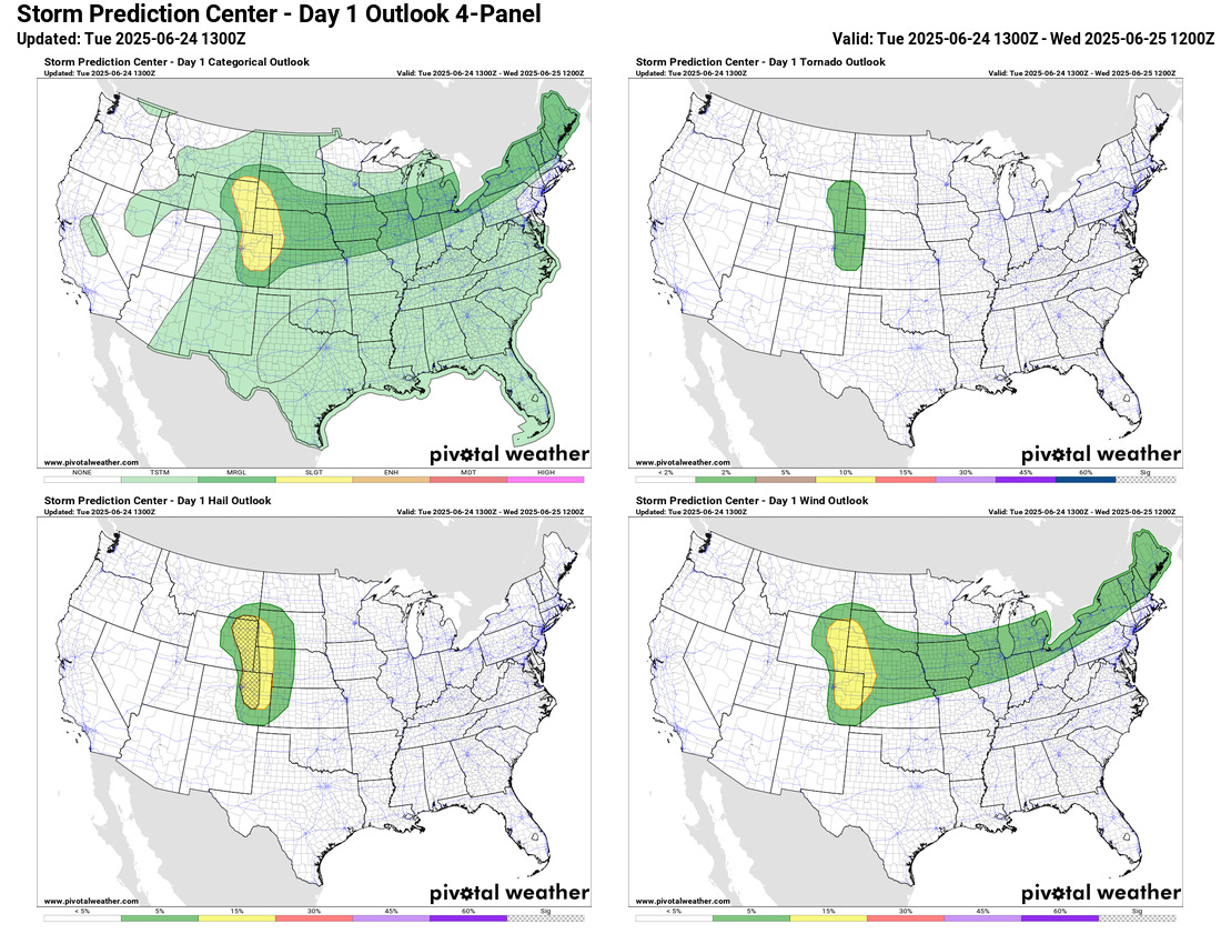
As far as severe weather is concerned, the primary focus today will be in the High Plains where scattered supercell storms capable of producing very large hail, strong downburst winds and a few tornadoes are expected this afternoon and evening. A marginal (level 1 of 5) risk extends east from there into the Northeast ahead of the slow moving cold front.

On Wednesday, a slight (level 2 of 5) risk is forecast for parts of the Southeast as the upper high begins to break down and an upper level low pressure area approaches the region from the southeast. The atmosphere will become quite unstable with plenty of heat and humidity still in place, and scattered severe storms primarily capable of damaging downburst winds are expected. A marginal risk will again be in place along the slow moving front from the Northeast to the northern Plains. Given that pockets of strongly unstable air will likely develop in this region, a few spots may need to have higher probabilities in later forecasts.

Finally, the National Hurricane Center started advisories recently on newly formed Tropical Storm Andrea, located well east of Bermuda. We talked yesterday about this system and the potential for a weak tropical cyclone to form, and that came to pass overnight. To be honest, my guess looking at the satellite loop above is that it reached tropical storm intensity for a brief period overnight and now has already weakened as all of the thunderstorm activity has been ripped off and dissipated by strong vertical wind shear. It could potentially make a very brief resurgence tonight if thunderstorms were to redevelop near the center - but overall this system will continue to weaken and pose no threat to any land. Andrea will be notable only for being the first named Atlantic system of 2025. No other tropical systems are of concern in the Atlantic basin for the next several days.