


Flash flooding hits DC Metro area on Saturday
Heat wave continues to build next several days
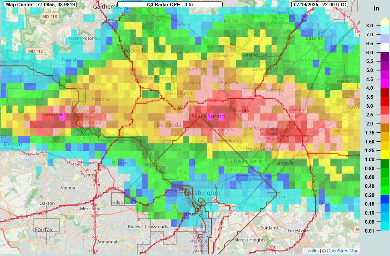
On Saturday afternoon, the northern part of the Washington, DC area became the latest urban area to deal with significant flash flooding. Ground zero was southern Montgomery County, MD and Silver Spring (coincidentally the location of the national headquarters of the National Weather Service). MRMS radar estimates showed an area of up to 4” of rain in 3 hours ending at 6 pm ET, and much of that rain fell in an even shorter period of time.

The MRMS FLASH unit streamflow product showed how the intense rainfall rates overwhelmed the urban areas, with values greater than 20 indicative of significant flash flooding.

This was also reflected in area stream gages, with Sligo Creek at Takoma Park near Silver Spring jumping 7’ in about 2 hours to a new record level (though this site has only been around since about 2010). Roadways became inundated with dozens of water rescues taking place and 20 people having to be rescued from a building surrounded by flood waters in Silver Spring. This story from Fox 5 in DC has more details and pictures of the flooding impacts.

More than 100 reports of flash flooding were received on Saturday from the Midwest to the Mid-Atlantic.

Sunday will see the flash flood risk focused again in the Midwest and Ohio Valley regions, with up to a moderate (level 3 of 4) risk across parts of northeast Missouri and central Illinois. The morning High Resolution Ensemble Forecast (HREF) is showing the potential for localized rainfall amounts up to 10” in the next 24 hours from slow moving clusters of thunderstorms with intense rainfall rates across the slight and moderate risk areas.

Severe weather was also associated with thunderstorms across the nation on Saturday, particularly over Nebraska and Kansas where more than a dozen reports of very large (greater than 2”) hail along with a number of reports of wind damage and a tornado.

Thunderstorms could produce more severe weather today. Along with slight risk areas over the Plains and Midwest/Ohio Valley, severe storms are possible in the Northeast with damaging downburst winds the primary threat.

Extreme heat will be an increasing hazard across the central and southeastern parts of the country for the next several days. Very humid conditions combined with above normal temperatures will result in building intense heat stress, with heat advisories and extreme heat warnings in effect for much of these areas.

This heat wave is expected to last for many days, and also expand west into the Plains as this week goes on.

Fire danger will be the primary risk in the West, as increasing winds and dry conditions will lead to a large area of elevated to critical fire danger across the Great Basin and Intermountain West by Monday.