


Erick makes landfall in Mexico as a major hurricane
Severe thunderstorms and extreme heat the big stories for the US
Hurricane Erick made landfall early this morning along Mexico’s Pacific coast near the border of Oaxaca and Guerrero states as a category 3 hurricane with maximum sustained winds of 125 mph. The structure of Erick went through some interesting evolution in the last 12-18 hours before landfall. As I talked about in a note late last evening, the infrared satellite data last evening showed some signs of a disrupting eyewall replacement cycle (EWRC) in Erick. The eyewall is the core ring of intense thunderstorms that surrounds the eye of a hurricane. In an EWRC, a new ring of storms forms a bit farther out from the eyewall and eventually develops into a new eyewall, choking off the initial eyewall. When this happens, the hurricane typically weakens a bit in intensity, but expands in size.
As I said in my note, while the disrupting EWRC looked to have started late in the afternoon, the satellite presentation of the hurricane improved again through the evening. This explanation by Alex on BlueSky that the EWRC started but failed seems on target, and this allowed the hurricane to resume intensification. NHC estimated that it peaked at a category 4 hurricane a few hours after this image above, but then it did start to more noticeably degrade in appearance .
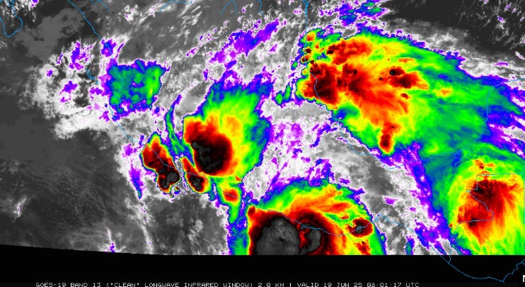
This satellite image is from around the time of landfall, and the eye had become indistinct, a clear sign of weakening. NHC estimates that it had weakened to a category 3 with maximum winds of 125 mph at landfall. Obviously, at that intensity it still likely caused tremendous damage as it made landfall with extensive wind and storm surge, though luckily that part of the coast is rather sparsely populated. The hurricane is now rapidly weakening over higher terrain, but will continue to cause extreme rainfall that will produce life-threatening flash floods and mudslides in the mountainous region of southern Mexico.
Regardless of the exact intensity at landfall, Erick was an incredibly impressive event for the east Pacific in June. I encourage you to read this post from my colleague Michael Lowry about all the various ways in which Erick was unusual. It strengthened by 80 mph in less than 24 hours, and was the earliest landfalling eastern Pacific major hurricane by more than 2 months.
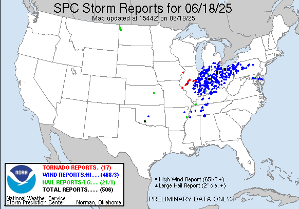
Turning back to the US, Wednesday was every bit the busy severe weather day it was anticipated to be, with more than 500 reports of severe weather, primarily numerous damaging wind gusts produced by an intense band of severe storms that formed in eastern Illinois late in the morning and then plowed east through the day. At the peak, more than 400K customers were without power along the path of these storms, with Indiana and Ohio hit the hardest. Several tornadoes occurred early in the event across central Illinois, and it is possible that damage surveys will reveal some additional tornadoes from circulations embedded in the line of storms as it moved east.
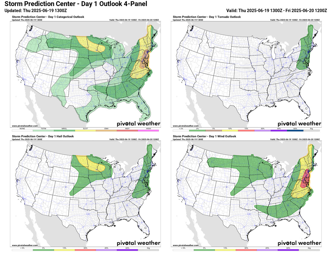
Yesterday’s storms dissipated overnight as they moved east into more stable air, but with daytime additional clusters and bands of strong to severe storms will develop along the Eastern Seaboard ahead of the advancing cold front. The Storm Prediction Center has placed an enhanced (level 3 of 5) risk of severe storms from the New York City metro area into the Delmarva with the expectation of numerous reports of damaging straight line winds. Large hail and a couple of tornadoes could also occur with the most intense storms. Intense downpours could also cause some localized flash flooding issues.
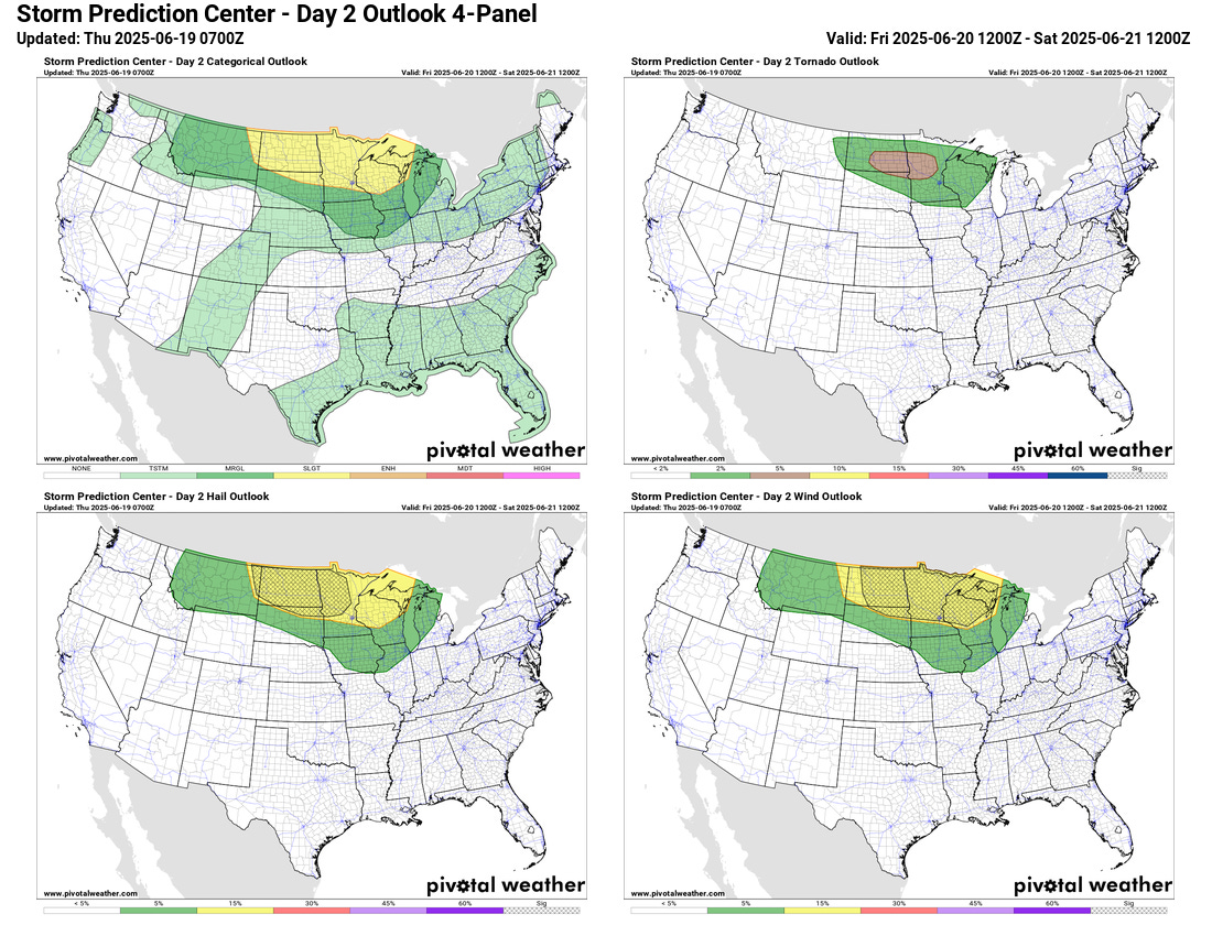
Scattered severe storms will also be possible in the upper Midwest later today, and on Friday, the main severe weather focus will shift back to that region as the cold front moves off the coast and a mid and upper level high pressure area starts to build over the East in its wake. Conditions look to become very supportive of intense severe storms by late Friday over a large area from eastern Montana into the western Great Lakes, and SPC has outlooked much of these region in areas of 10% significant severe weather probabilities for very large hail, significant damaging winds, or both. The exact forcing mechanisms for storm development are still somewhat uncertain, and once this becomes clearer it is possible that the severe weather risk will be upgraded from slight (level 2 of 5).
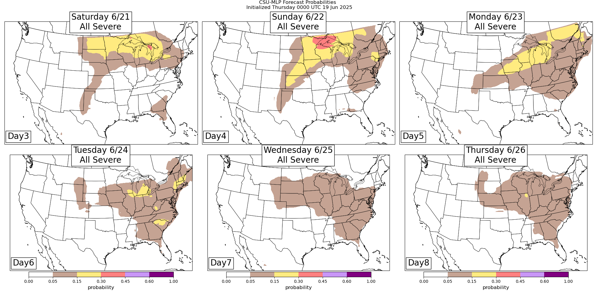
As the heat dome of high pressure strengthens over the East this weekend into early next week, this general severe weather pattern will remain in place through Monday. Beyond Monday, the severe weather risk becomes more uncertain as the exact evolution of the high pressure area and disturbances rotating around it becomes harder to anticipate.

Speaking of the heat dome, all signs continue to point to an unusually strong and prolonged heat wave for much of the Midwest and Eastern United States into next week.

The heat will start to build in the central United States today and Friday, with a number of record high temperatures expected on Friday from the Colorado Front Range into the Missouri Valley region.
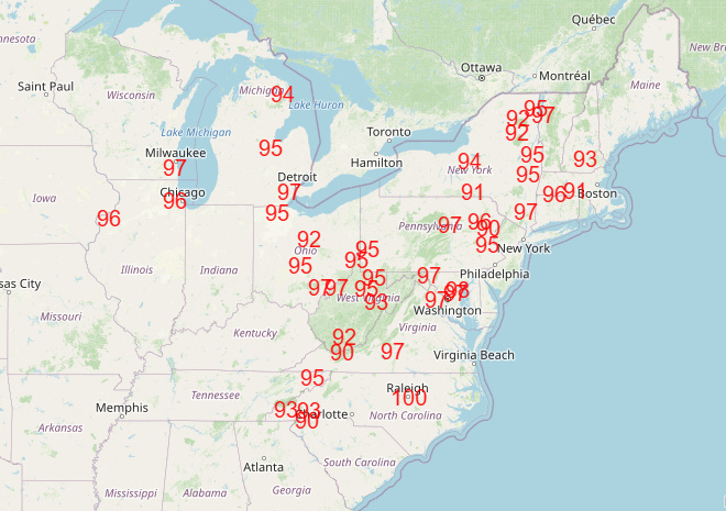

As mid and upper level high pressure builds and strengthens to near record levels across the East this weekend and early next week, the central US heat will expand and spread East, and by Monday and Tuesday numerous record warm temperatures - both record maximums and record warm minimums - looks to be set over much of the Northeast, Great Lakes and Mid-Atlantic states. (Monday forecast record maxes and Tuesday forecast record warm mins shown above)
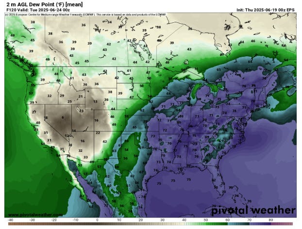
The heat looks as it if will accompanied by extreme humidity as well. This is a forecast of surface dewpoint values from the European ensemble model for 8 pm ET Monday, showing 70+F dewpoints widespread across the eastern half of the country.

These levels of dewpoints indicate oppressive humidity, which combined with the record heat will lead to widespread levels of major to extreme heat risk through the weekend and into early next week (HeatRisk map for Tuesday shown above).
As we get later into next week, the footprint of the heat wave may begin to shrink a bit as the dome of high pressure starts to slowly weaken. However, for at least the Mid-Atlantic and Southeast, the heat is likely to persist for most of next week, making for a very unusual, prolonged period of dangerous heat stress.
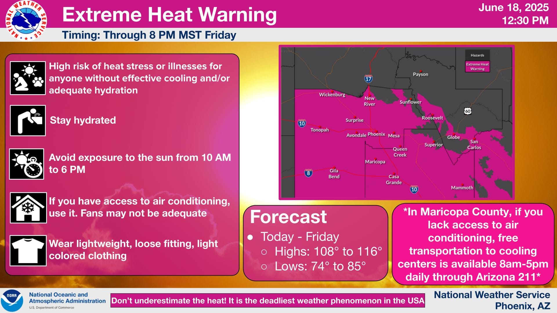
Extreme heat is also an issue in the Southwest, where Phoenix hit 114F on Wednesday. Warnings remain in effect for much of the Desert Southwest today and Friday with widespread 110+F readings expected; this weekend should see a reprieve from the heat here as an upper level trough of low pressure forms upstream of the eastern US high pressure area.