


Deadly flash flooding in West Virginia
Busy week of severe weather upcoming
Societally impactful weather events occur when a weather event interacts with the natural terrain and/or human built structures in a way that results in negative impacts. Last night we saw a classic example of how localized thunderstorms occurred in exactly the wrong place and the wrong time to result in tragic impacts.

We have been talking the last few days about how locally heavy rainfall could cause isolated flash flooding issues across much of the eastern US. During Saturday evening, a relatively small band of thunderstorms developed from the central West Virginia Panhandle into southwest Pennsylvania, and caused a band of 1-3” of rain in about 3 hours, with a localized maximum of 2-4” just east of Wheeling, WV.

Unfortunately, that localized maximum in rainfall fell in an area with complex terrain and in the headwaters of creeks and streams that run through Wheeling into the Ohio River. With high rainfall rates - much of the rain shown in the map above fell in about 2 hours - and wet soils from a wet spring in the region, rapid runoff occurred and streams and creeks saw extremely rapid rises out of their banks. An example is shown above as Wheeling Creek rose from less than 3 feet to 10 feet and well above flood state in a matter of minutes.
Wheeling fire department emergency management director Lou Vargo was quoted by The Weather Channel as stating that the resulting flash flooding was the worst he has seen in his 35 years of work in the region, with vehicles submerged and buildings destroyed. Unfortunately, 3 people have been confirmed to have been killed by the flash flooding.
There has obviously been a lot of talk about NWS staffing in recent months, and I feel I must make a related point in regards to this tragic event. Events like this are not possible to anticipate significantly in advance. While there was some anticipation of a somewhat heightened risk for flash flooding given the above normal moisture and recent rainfall with a marginal (level 1 of 4) risk of flash flooding in place from the Weather Prediction Center, these sorts of conditions are not uncommon and certainly did not imply that a population center would see its worst flooding in decades. Localized high impact events like this can happen on a moment’s notice, which is why it is crucial to have a robust National Weather Service that is literally on alert and ready to issue warnings 24/7. In this case, the NWS appears to have issued appropriate flash flood warnings and worked with local emergency management to upgrade these warnings, eventually to a flash flood emergency, the highest level.
However, the ability for all offices to continue to provide effective warnings has to be of concern given that a number of offices are no longer operating 24/7 and are relying upon other offices to provide services at times when they are closed. Instead of the across the board cuts and staff reductions that the NWS has been subject to over the last few months, we need to be able to refocus on ensuring the NWS has the necessary resources to keep meeting their mission, and how to best organize the agency going forward to meet evolving societal needs.

Looking ahead at the flash flood risk for today, a widespread marginal risk of excessive rainfall is in place over most of the eastern United States, with a few slight risk areas where more concentrated areas of thunderstorms producing heavy rain are expected. The area over the Mid-Atlantic into the central Appalachians appears to be the most vulnerable given recent rainfall and above normal moisture values, and WPC has put a moderate (level 3 of 4) risk for parts of southeast Virginia and northeast North Carolina.

With regard to severe thunderstorms today, the primary focus looks to be over the northern High Plains where an upper level disturbance will move through stronger mid and upper level winds north of an upper level high pressure center over the Southwest. Given a very unstable air mass, scattered supercell storms with very large hail, significant straight line winds, and a few tornadoes are anticipated, with the highest risk over eastern Montana and adjoining parts of the Dakotas.
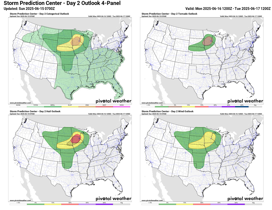
The weather disturbance responsible for today’s severe weather should shift east into the upper Midwest on Monday, with an enhanced (level 3 of 5) risk of severe storms as scattered intense supercells with very large hail, damaging winds and tornadoes are anticipated.

The next couple of days looks to be a start of an active period of severe weather for the next several days, particularly over the northern and eastern parts of the country as disturbances rotate around a high pressure area over the southern states.

Underneath the high pressure center over the Southwest, extreme heat will be the story the next couple of days, with extreme heat warnings in effect as temperatures are expected to rise above 110F in many areas.

After a brief weakening in the upper level high pressure center after Monday, it is expected to rebuild later in the week with heat building into the middle part of the country. This heat is expected to shift east into the Great Lakes and eastern United States by early next week.

The eastern Pacific continues to be the focus of attention in the tropics, with Tropical Storm Dalila expected to turn west and weaken while another system looks likely to develop west of central America with potential impacts to coastal regions there. Most of the models now imply that the eastern Pacific will continue to be the area of focus with little risk of development in the Atlantic over the next week.
This reminds me of the Shadyside, Ohio disaster just across the Ohio river. Much better detection capability today but still difficult to message. https://repository.library.noaa.gov/view/noaa/50937