


Catastrophic overnight flash flooding in central Texas
Also likely to see a tropical cyclone east of Florida in next 24 hours
The Hill Country of central Texas is known colloquially as “flash flood alley” because of its high frequency of major flash floods. The region is particularly vulnerable to major flash floods because of the frequency of intense thunderstorms that can produce extreme rainfall rates in the moist Gulf air combined with terrain that favors rapid runoff into flashy rivers and streams. Unfortunately, the region lived up to its reputation overnight as serious flash flooding evolved in the area northwest of San Antonio.
I have mentioned in past posts that tropical systems can form along old fronts through numerous thunderstorms developing and persisting long enough that they start to organize and form low pressure. A similar process can happen over land when the atmosphere is particularly moist, and as you can see in this 6 hour loop of radar from the Hill Country overnight, as thunderstorms evolved repeatedly over the same region a clear spin develops indicating a developing area of low pressure. This process helped focus the rainfall and increase the intensity of the rainfall rates with the individual storms.

The 12-hour rainfall estimate from the Multi-radar Multi-sensor System (MRMS) ending at 11 am CT shows a large area of heavy rainfall greater than 4” from San Angelo to northwest of San Antonio, with several swaths of 6-12”.
A 6 hour loop of the MRMS FLASH unit streamflow hydrologic product which shows runoff and inundation shows a number of large areas of values greater than 20 - extreme values indicative of major to catastrophic flash flooding.

River gages in the region show the terrifying results. The Guadalupe River at Hunt - northwest of Kerrville and near the southernmost 10+” maximum in the map above - went from 7.7’ at 1:10 am to 29.45’ at 4:35 am, the 2nd highest level ever recorded and the highest in nearly 100 years. The flow in cubic feet per second went from 8 cfs to 120,000 cfs over the same period, meaning it went from essentially a dry riverbed to a raging massive river in a matter of about 3 hours. It actually appears that the gage failed at this point - so the actual levels may have been even higher. Unfortunately, this area is home to a number of campgrounds and similar facilities along the Guadalupe River and given the holiday, devastating impacts have likely happened. The Kerr County sheriff is already reporting that an unknown number of fatalities have occurred.

Unfortunately, the event is not yet over, as thunderstorms with high rainfall rates continue moving slowly east across the region at midday.

The mid and upper level weather disturbance that has formed from the storm complex will produce additional thunderstorms with torrential rainfall farther away from its center as the afternoon goes on, with more flash flooding likely. Slight (level 2 of 4) to moderate (level 3 of 4) risks of flash flooding are in place for much of central Texas for today. This plume of unusually high levels of moisture - which was likely assisted by remnant moisture from tropical storm Barry - has surged north through the Plains and will also help feed thunderstorms over the upper Midwest where another slight risk of flash flooding is in place.
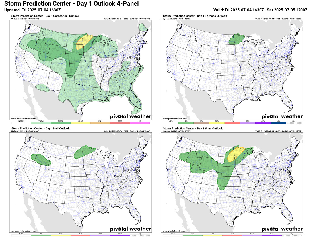
A slight (level 2 of 5) risk of severe weather is also in place for this region, with damaging winds the primary risk.

As if all of that was not enough, rising temperatures combined with the unusual high levels of humidity will result in significant heat stress across the upper Midwest today, and heat advisories and extreme heat warnings are also in place.

The other big weather story today is off the east coast of Florida, where morning visible satellite images suggest an area of low pressure is gradually getting better organized. An Air Force Reserve Hurricane Hunter aircraft is scheduled to investigate the developing system later today. NHC has the probability of tropical cyclone development at 60%, and given recent satellite trends and increasing support from the models, it seems increasingly likely that a tropical depression will develop over the next day or so in this region. The system still looks to drift north toward the Carolina coast and will likely move inland later this weekend, and certainly it would not be surprising for the system to be a tropical storm by that point.

Regardless of development, heavy rainfall will likely be the most significant risk with this system, and the Weather Prediction Center at this point is forecasting widespread 3-5” of rainfall from the Myrtle Beach area across eastern North Carolina and into the Virginia Tidewater area.


Looking at weather for the rest of the country this weekend, scattered to numerous thunderstorms are anticipated in the unusually moist atmosphere across much of the eastern two-thirds of the country. A slight risk of severe storms is in place for the northern High Plains region on Saturday.
Looking at the satellite presentation over the past 24 hours, had I not known the geography underneath, I would have sworn a tropical cyclone had blossomed. Dramatic cyclogenesis evident in all the radar imagery and an excellent upper outflow. The Guadalupe at Comfort shot up from 3.15' to 34.76' in a flash.
I know this sort of thing can easily be found in past instances and perhaps some thought should be given to recognizing it as an entity- "Land Originated Tropical Cyclone (LOTC)". I don't believe it was properly anticipated in this case. A suggestion for future research.
Awful loss of life. Perhaps it will at least help mitigate the exceptional drought in that region.