BalancedWx Special: Science of flash and urban flooding
And why we are in danger of losing crucial related research
While severe weather - especially tornadoes - tends to be the big headline generator from springtime thunderstorms, flash flooding can often be the more impactful and deadlier hazard. That was sadly the case from the storms this past weekend, as 2 people including a 12 year old boy were killed in flash flooding Saturday evening in Moore, OK (a third fatality was reported from a tornado in Spaulding, OK). Southern parts of the Oklahoma City metro area experienced serious flash flooding Saturday evening with water rescues taking place as vehicles were swamped or swept away by flood waters.
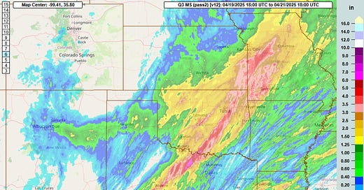
If you look at the rainfall graphic from the weekend above, your eye is likely drawn to the heaviest rain swath of 3+” running from central Texas through eastern Oklahoma and up into western Missouri between Kansas City and Columbia. While there were certainly some reports of significant flash flooding from within that area, the fatalities and likely more significant and numerous impacts occurred in that much smaller and narrower band of 2-4” of rainfall across central Oklahoma.
Flash flooding is a complex hazard that depends on more than just rainfall amount. The likelihood and magnitude of flash flooding depends on how much rainfall runs off the ground and can inundate small streams, creeks, drainage structures, roads, etc. With regard to rainfall, runoff is primarily related to the rate at which it falls: the higher the rainfall rate, the more of the rain that will runoff.
Of course, the amount of runoff is also dependent upon the surface the rain is falling on; wet ground cannot absorb as much rain as drier ground, so as more rain falls in a given area, a higher percentage of it runs off. Urban areas are particularly susceptible to flash flooding, as impervious surfaces such as asphalt and concrete do not absorb any of the rainfall, so all the rainfall goes to runoff. While obviously urban areas are engineered to try to minimize flash flooding using things like storm sewers and retention ponds, these mechanisms can be overwhelmed when rainfall is particularly heavy.
Again, the rainfall rate tends to be the most critical element in urban flash flooding as engineers design things like roadways and drainage systems accounting for the probable maximum precipitation (PMP) at a given location over a period of time such as 1 or 6 hours. If the rate of rainfall exceeds the design of critical urban infrastructure, flash flooding can occur very quickly.
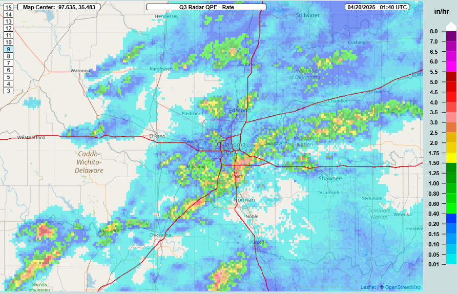
To look at what transpired with the flash flooding in the Oklahoma City area Saturday night, we can start by looking at the Multi-Radar Multi-Sensor (MRMS) rainfall rate product for around the time of the flash flooding. (Real-time operational MRMS products can be viewed here.) This product is generated using radar data, and showed that thunderstorms with rainfall rates of 3 to 5 inches per hour were moving through the southern and eastern parts of the metro area. This is an instantaneous rainfall rate, in other words the rate of rainfall occurring at any given moment.
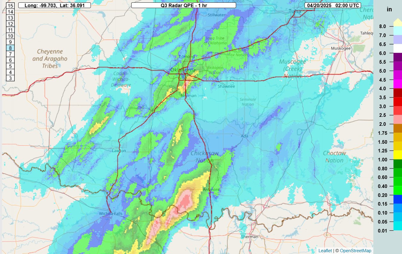
Obviously, storms move and evolve so that rate does not necessarily stay over a point for any particular length of time. So we need to generate products that add that rainfall rate up and give us rainfall amounts over a particular length of time. The graphic above shows the MRMS rainfall estimate for the hour ending at 9 pm CT, around the time the flash flood deaths were reported. You can see there is a rather significant area of 2 to 3” of rain in an hour across the southern part of the OKC metro including Moore, where the fatalities occurred.
If you are a meteorologist tasked with warning people about the potential for flash flooding in a given area, the MRMS rainfall estimates are obviously very helpful. What would be even more helpful, though, is to be able to contextualize how that rainfall might compare to the PMP in a given area, or even to have an explicit estimate of how much runoff is occurring. The MRMS FLASH (Flooded Locations and Simulated Hydrographs) system produces products that give forecasters that sort of information.
This FLASH product takes the MRMS estimated rainfall and compares it to historical rainfall observations to give an estimate of the likelihood for that amount of rainfall to occur in any given hour, expressed here as the return period. For the area around Moore, the return period for the estimated rainfall is 10 years, essentially meaning that there is a 10% probability that rainfall amount will occur at that given point in a year (i.e., this amount of rain can be expected on average at any point once every ten years).
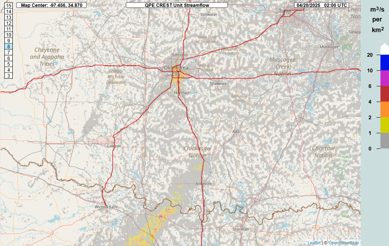
This FLASH product is “unit streamflow.” For this product, the MRMS rainfall estimates are run through a hydrologic model which accounts for the surface the rainfall is occurring over, i.e., wet ground or urban areas produce more runoff than dry ground. This provides an estimation of surface runoff and inundation at each point which is a very good proxy for flash flood potential. Here, as one might expect given the reports that occurred, the values of unit streamflow are maximized over Moore with high values over much of the southern part of the OKC metro area.
Just to further demonstrate the importance of having a product like unit streamflow in addition to rainfall estimates, here is the MRMS one-hour rainfall and unit streamflow at 9 pm CT over a larger area of southern Oklahoma and north Texas. There is a much larger area of greater than 2.5” rainfall amounts southwest of Ardmore, but the unit streamflow shows much lower values than in the OKC metro area. Conversely, while the rainfall amounts southwest of that area across northern Texas are lower than over Oklahoma, the unit streamflow values are much higher. Clearly, the impervious urban area of the OKC metro resulted in much more runoff and flash flooding than did the similar rainfall amounts in the rural areas southwest of Ardmore. Meanwhile, greater rainfall prior to the hour of this rainfall meant that the rain in northern Texas resulted in more runoff and potential flash flooding than in the area over southern Oklahoma.
What we are in danger of losing
Hopefully this deep dive has given you some appreciation for the science of flash flooding, the challenge a meteorologist has in providing actionable information about it, and some of the tools meteorologists have to assist them in evaluating flash flood potential. It is important to understand that all of this is based on literally decades of research and development by the scientific community, primarily by NOAA affiliated or funded research scientists.
MRMS has been in development for more than 25 years at the National Severe Storms Laboratory (NSSL), worked on by dozens of research scientists - both federal scientists and scientists with the University of Oklahoma Cooperative Institute for Severe and High-Impact Weather Research and Operations (CIWRO). MRMS integrates data from the US and Canadian radar networks along with other observational data to produce products as frequently as every 2 minutes. This includes not only the hydrometeorological products that we have talked about here, but also severe weather products used extensively by the Storm Prediction Center, aviation products used by the FAA and NWS aviation meteorologists, and other decision support products. MRMS products are used extensively by the entire meteorological community - public and private sector - as well as the general public for a variety of applications.
MRMS became an operational NWS system in 2014 after an extensive research-to-operations process that involved experiments in the NOAA Hazardous Weather Testbed (HWT) with NWS forecasters to evaluate the products and validate their utility for NWS operations. As research has continued to advance in the last decade, multiple teams of NSSL and CIWRO scientists and software engineers have continued to improve and advance the algorithms and programs that underpin MRMS. As an example, in recent years extensive work has been done to investigate the use of artificial intelligence techniques to improve MRMS rainfall estimates. This work shows promise to make significant improvements to radar rainfall estimates especially over the complex terrain of the west, potentially providing benefits to flood forecasting and water resource management if and when it can be implemented into MRMS operationally.
What I discussed above about the flash flooding Saturday night was focused on tools to evaluate flash flood potential once rain has fallen; the next crucial step would be to anticipate heightened flash flood potential before the rainfall occurs. Work has been ongoing for several years now at NSSL to couple the Warn-on-Forecast (WoFS) modeling system with the FLASH system to provide meteorologists with products like unit streamflow as a forecast instead of just an analysis. An experiment conducted in the HWT with NWS forecasters using products from an initial version of a coupled WoFS/FLASH system showed potential for forecasters to be able to issue flash flood warnings before storms even start affecting an area. This could enable people to take proactive actions like avoiding travel or evacuating flood prone areas before heavy rain even starts.
Finally, the precipitation estimates used for PMP by engineers are based upon NOAA data. The NOAA Physical Sciences Lab (PSL) is currently engaged in a multiyear project to modernize the PMP definition and underlying data for the United States to support improved engineering and design of buildings and infrastructure. This work was Congressionally directed by the bipartisan PRECIP act which was signed into law in late 2022.
Everything I have discussed here - MRMS research and development, the Hazardous Weather Testbed, WoFS and developing it for flash flood forecasting, and the PMP modernization project - would be terminated under the FY2026 NOAA budget as outlined in a recent Office of Management and Budget (OMB) passback document. All of the NOAA Research Labs - including NSSL, PSL, and the Global Systems Lab, which develops the data visualization and warning generation software for the NWS - would be closed. All of the NOAA affiliated university cooperative institutes like CIWRO that conduct much of the day-to-day research and development work would also be eliminated.
When I started working in meteorology in the late 1980s, none of what I have discussed in this article (other than the concept of PMP) was even conceived of. The Doppler weather radar network had not yet been implemented, and flash flood warnings were essentially issued by the NWS when flooding was reported. The progress that has been made in the intervening years is remarkable, and we are just talking here about NOAA research advancements in flash flood detection and prediction, not all the other hazards and programs in the NOAA weather and water portfolio. The thought that we are going to intentionally dismantle the scientific infrastructure that has accomplished so much - and is in the process of accomplishing so much more - for society over the years is literally incomprehensible to me.
One of my main goals in starting Balanced Weather was to be able to share background and stories about the scientific work that is advancing our understanding of the atmosphere and our ability to predict and warn for the hazards it presents. I will continue to focus on that in the coming days and weeks given the threats that now exist to this science in the hopes of illustrating what exactly is in danger of being lost.


