


Another active severe weather day with possible tornadoes in Midwest
Erick likely to become a major hurricane in eastern Pacific before landfall in Mexico

Happy hump day! Tuesday was a busy day with regard to severe weather in several different areas. In the middle of the country where a moderate risk of severe storms was in place, an initial wave of severe storms developed over southern Kansas in the afternoon, producing significant wind gusts in the Wichita area for the second time in 24 hours. Those storms evolved into a complex which moved southeast across northeast Oklahoma just to the north of an old boundary left by the storms that had moved through Wichita early Tuesday morning. A number of reports of damaging wind and large hail occurred with those storms.
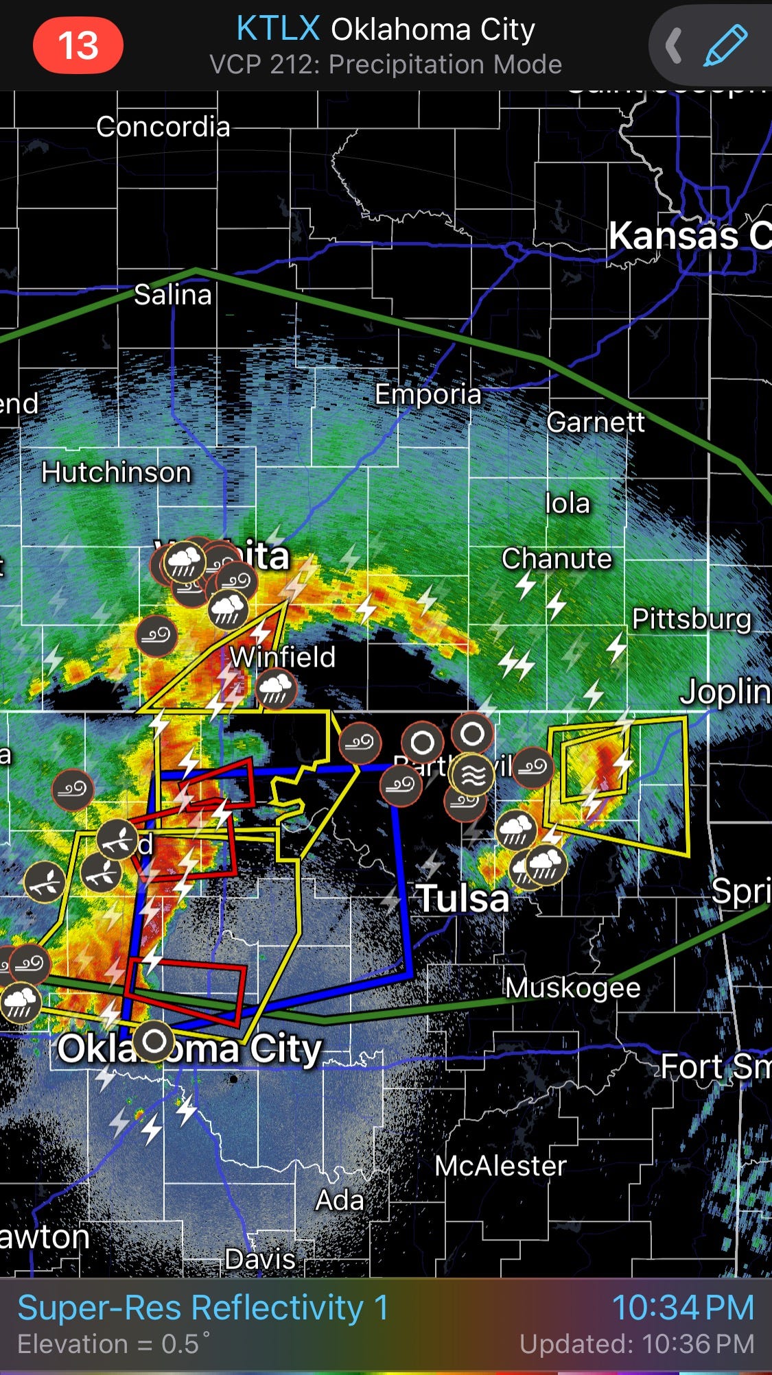
Additional severe storms developed Tuesday evening in northwest Oklahoma and became a rather intense quasi-linear convective system (QLCS, squall line) which moved across Oklahoma north of Interstate 40 with a number of reports of hail and wind damage, as well as a couple of tornadoes including confirmed tornadoes around Tahlequah, OK this morning. The Oklahoma Mesonet had a maximum measured wind gust of 71 mph at the Talala site, with a number of sites reporting severe wind (58+ mph) wind gusts with this QLCS.
Additional severe storms occurred Tuesday in the High Plains from Colorado north, with several supercells producing tornadoes, large hail and damaging winds. A cluster of severe thunderstorms in the Southeast produced a number of reports of damaging downburst winds.
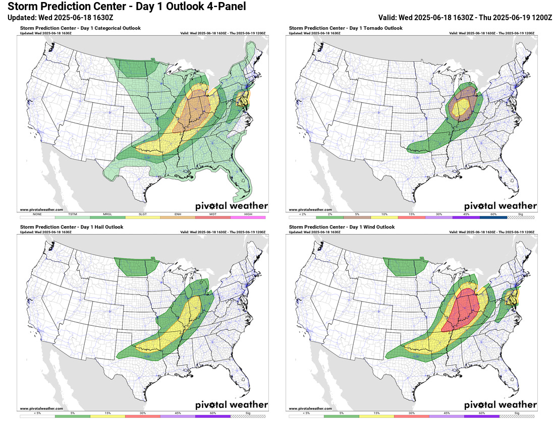
Today will be another active day as SPC has an enhanced (level 3 of 5) risk of severe storms for a large area from southern Lower Michigan into the lower Ohio Valley.
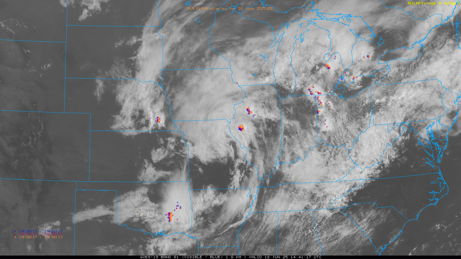
While the enhanced risk is primarily in place for the threat of numerous incidences of damaging winds along a band of severe storms expected to develop, I am increasingly concerned about the tornado risk as well. If you look at the visible satellite imagery this morning, you can see a very well developed spin north of St. Louis. This is indicative of a developing low pressure center which recent models have trended a bit stronger with. Satellite shows there should be quite a bit of sunshine the next few hours across Indiana which should lead to increasing instability, and as thunderstorms develop in an environment of increasing low level wind shear due to the low pressure center, the risk of tornadoes should increase.

A tornado watch is already in effect for parts of Illinois and eastern Missouri, and SPC’s late morning update has increased the tornado risk across Indiana and eastern Illinois to an enhanced level. Bottom line - folks in these areas should be on their toes and monitoring later forecasts today as the threat of severe weather, including some tornadoes, should increase.
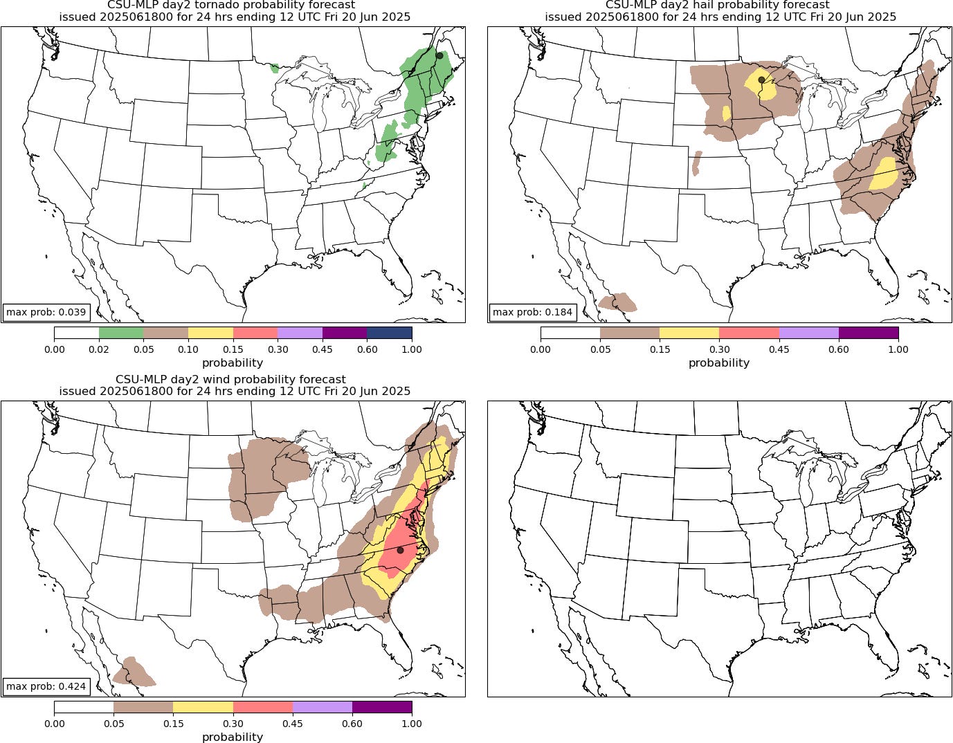
As the low pressure system and cold front moves east on Thursday, it will bring a risk of severe weather to the Eastern Seaboard as shown by the Colorado State University Machine Learning Probability guidance. Damaging downburst winds look to be the main risk as bands of severe storms develop along the cold front, but sporadic large hail and a few tornadoes are also possible.

Locally heavy rain and associated flash flooding are also possible with the storms across the Midwest and East the next couple of days.
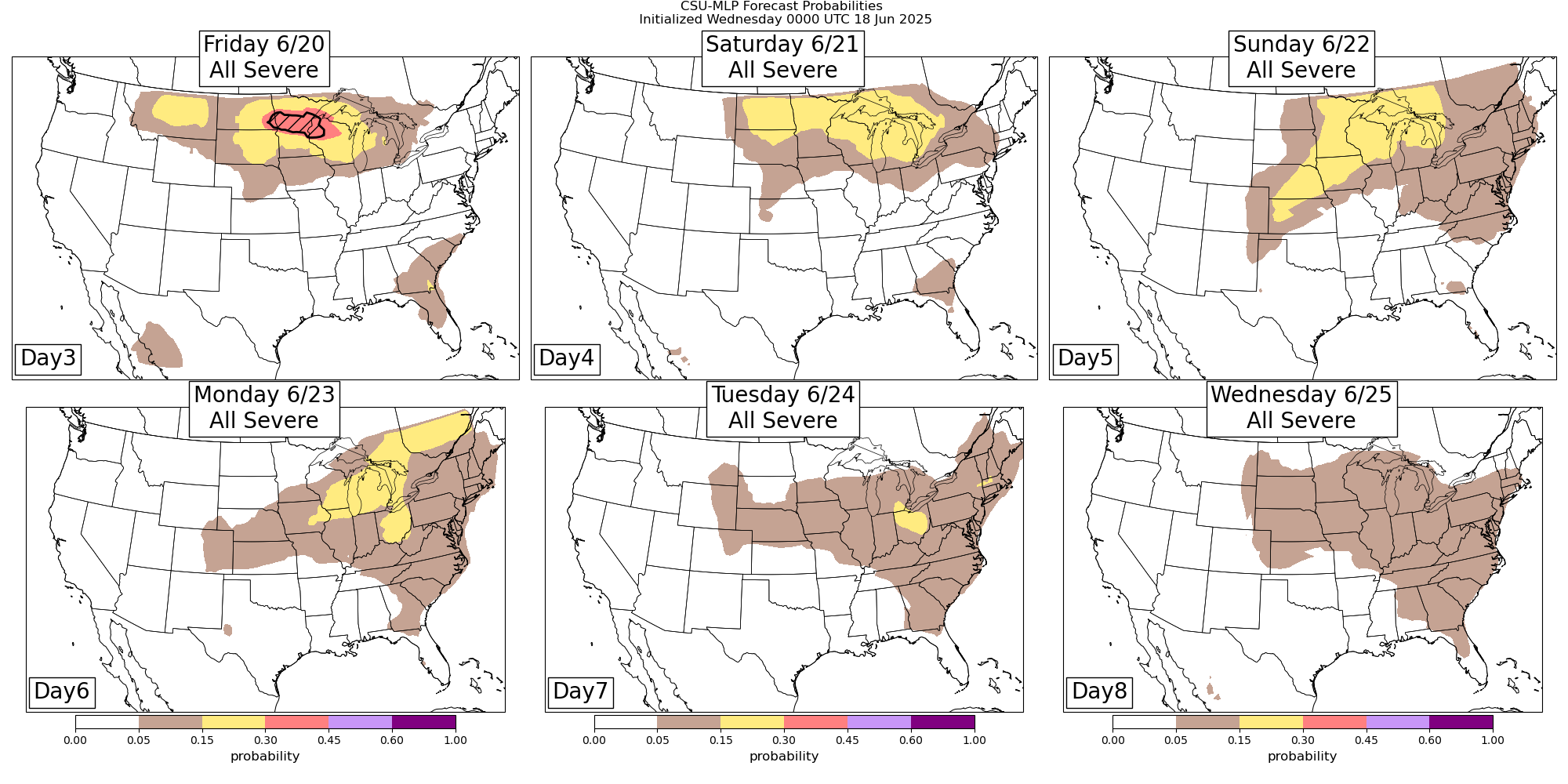
As we have been discussing the last few days, an active period for severe weather is expected to continue late this week and early next week as a disturbances rotate around the unusually strong area of high pressure in middle and upper levels of the atmosphere that will develop over the eastern US. Friday is showing signs of being a another potentially very active day for the northern tier of states, with severe risks continuing into the weekend.
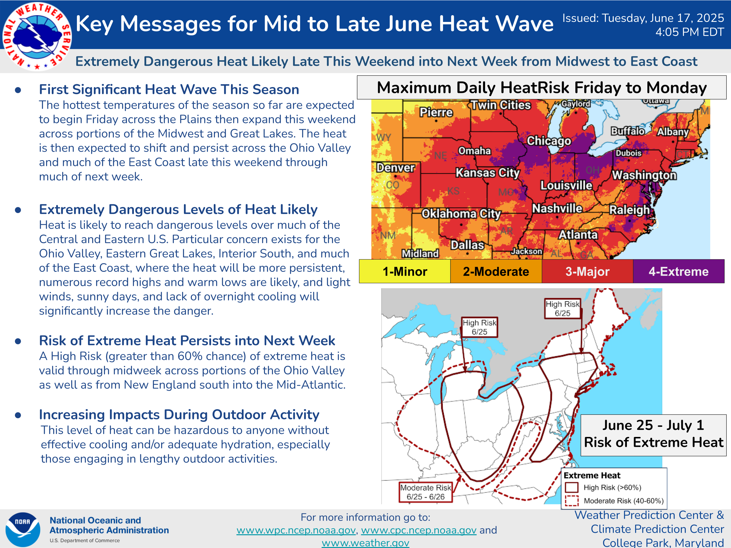
Under this building dome of high pressure, a prolonged and high impact heat wave is expected over much of the eastern United States late this week into next week.
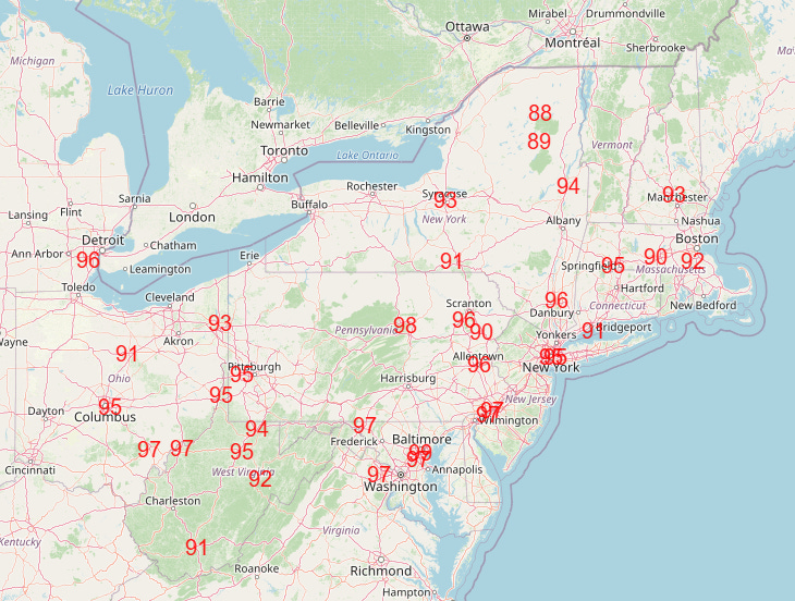
Along with the potential for a number of record high temperatures by early next week (Monday’s forecast records shown above), humidity is expected to be very high, which will result in high heat index values and even more numerous record high minimum temperatures. The heat is expected to last much of next week across the East.

In the Southwest, heat stress will be a significant concern the next few days, and extreme heat warnings are in effect for across much of the Desert Southwest. This heat will break a bit for a few days this weekend and early next week as an upper level trough of low pressure develops upstream of the major heat dome in the East. Fire danger and wildfires are becoming an increasing concern in the West, and I encourage you to check out this excellent summary from The Hotshot Wake Up.
![[Key Messages]](https://substackcdn.com/image/fetch/f_auto,q_auto:good,fl_progressive:steep/https%3A%2F%2Fsubstack-post-media.s3.amazonaws.com%2Fpublic%2Fimages%2Fac13ca4c-fa9b-41b4-82ce-37292d1afc8b_897x736.png "[Key Messages]")
Last, but certainly not least, Erick has become a hurricane in the eastern Pacific, and recent satellite and reconnaissance data suggests it is continuing to intensify. NHC forecasts Erick to become a major hurricane before landfall tomorrow east of Acapulco. The approach to the coast will be somewhat parallel to land, so small track deviations could have large landfall point affects. Regardless, significant impacts are expected as described above by NHC.
Given all of the busy weather over the next few days, I am planning to initiate some live chat and video briefings, and am currently doing a live chat of the USAF reconnaissance flight in hurricane Erick. As a reminder, live chat and video are Balanced Weather paid subscriber benefits - you can find out more information at the link below.